Beobachtungen
Observations:
Geologische Strukturen
Geological Structures
Im Oberharz gibt es viele unterschiedliche Gesteine und geologische Strukturen. Bei der Entstehung des sich aus der übrigen Landschaft heraushebenden Gebirges gab es große Kräfte, die zu Verschiebungen und Verformungen einzelner Bereiche geführt haben. In manchen dieser Spalten, die sich etwa von Ost nach West erstrecken, haben die Bergleute das Erz gefunden.
Die heutige GPS-Technik erlaubt es, die Position von markanten Punkte im Gelände zu speichern und deren Lage später auf dem Rechner in Karten oder Luftbilder einzutragen. Unter günstigen Bedingungen beträgt die erreichbare Genauigkeit bei preiswerten Hand-Geräten nur wenige Meter.
Somit lassen sich gespürte Informationen von geologischen Strukturen oder anderen Objekten unter der Erdoberfläche auf einfache Weise lagemäßig mit beispielsweise geologischen Karten vergleichen.
In der Liste am Anhang sind Name, DatumUhrzeit, Koordinate und Geländehöhe eingetragen.
In the
Oberharz there are many different rocks and geological structures. With
the emergence of the mountains by lifting out from the remaining
landscape
there were large forces, which led to shifts and deformations of
individual ranges. In some of these fissures, which extend for instance
from east to west, the miners found the ore.
The today's GPS technology makes it possible to store the position of distinct points in the area and to mark their position later on with the computer in maps or aerial photographs. Under favorable conditions the attainable accuracy with inexpensive hand instruments amounts to only few meters.
Thus the position of perceived geological structures or other objects under the earth's surface can be compared in a simple manner with for example the details in geological maps.
In the table below are registered name, date time, coordinate and elevation (barometric height).
Die ersten Erfahrungen mit dieser Technik sind: The today's GPS technology makes it possible to store the position of distinct points in the area and to mark their position later on with the computer in maps or aerial photographs. Under favorable conditions the attainable accuracy with inexpensive hand instruments amounts to only few meters.
Thus the position of perceived geological structures or other objects under the earth's surface can be compared in a simple manner with for example the details in geological maps.
In the table below are registered name, date time, coordinate and elevation (barometric height).
- Geologische Karten enthalten nicht jedes kleinste Detail.
- Gespürte Echos von Strukturen oder deren "Beugungsmuster" können ein komplexes Bild liefern, das einerseits einfach zur Bestimmung der Richtung einer Störung zu nutzen ist, andererseits aber deren genaue Positionsangabe erschwert.
- Beim Abgehen des Geländes mit der "natürlichen
Methode" lassen sich sehr schnell
größere Strukturen
aufnehmen.
spurrinne
Beispiele für die Dauer der einzelnen Abschnitte:
(die zugehörigen Punkte sind in Abb. 07 und in der Liste zu erkennen)
203 bis 219 6 Minuten
220 bis 234 7 Minuten
384 bis 402 9 Minuten
The
first
experiences
with
this technology are:
* Geological maps do not contain each smallest detail.
* Felt echoes of structures or their "interference fringes" can produce a complex picture, which can be used on the one hand for the simply determination of the direction of a disturbance, on the other hand however makes it more difficult to examine their exact position.
* When going over an area with "natural method" natürlichen /E larger structures can be examined very fast. spurrinne
Examples of the duration of the individual sections:
(the associated points are in fig. 07 and in the lable)
203 to 219 6 minutes
220 to 234 7 minutes
384 to 402 9 minutes
GPS-Daten
Die Daten wurden mit dem abgebildeten Empfänger (Abb. 01 aufgenommen und per Programm MapSource auf den Rechner eingespielt.
Sie liegen im Format .GDB vor Beispiele hasenbach-001.gdb hasenbach-002.gdb hasenbach-003.gdb
Sie enthalten "Waypoint" und "Track"-Daten
MapSource kann daraus (Keyhole)Markup Language (.KML) Informationen erzeugen, die von GoogleEarth verarbeitet werden können. Die KML Daten sind ähnlich wie XML-Daten aufgebaut und enthalten neben sehr viel Steuerinformationen nur sehr wenig aktuellen Inhalt. Sie sind daher sehr groß. GoogleEarth speichert sie daher gezippt ab als .KMZ .
Informationen zum Umgang mit GoogleEarth, Einstellung ... gosetal.htm#luftbilder
Die Daten lassen sich aber auch mit GPSBABEL lesen und in ein anderes Format umwandeln. http://www.gpsbabel.org/
The
data
were
recorded
with the shown receiver (fig. 01) and transferred in
to the
computer by the program MapSource.
Their format is .GDB examples hasenbach-001.gdb hasenbach-002.gdb hasenbach-003.gdb
The data include waypoint and track informations.
Map SOURCE can export (Key-hole)Markup Language (.kml) information, which can be processed by GoogleEarth.
The .kml the data are similarly to XML data and contain beside very much control information only very little current contents. They file are from there very large. GoogleEarth stores them zipped as .KMZ.
Information using GoogleEarth, preferences. . . see gosetal
The .GDB data can be read also by GPSBABEL and converted into some other formats. http://www.gpsbabel.org/
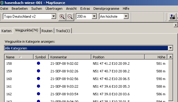 |
| Abb. 0.1: MapSource, Waypoint
data (FB) |
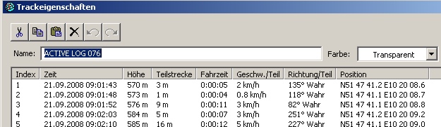 |
| Abb. 0.2: MapSource,
Track-information (FB) |
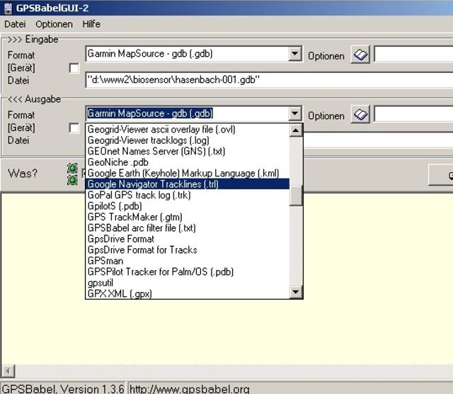 |
| Abb. 0.5: Programm GPSBabel zum
Umwandeln von GPS-Informationen. Changing the file format http://www.gpsbabel.org/ |
 |
 |
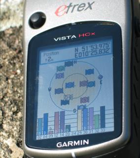
| Abb. 01: GPS-Empfänger Darstellung der Satelliten-Empfangsstärke. Bei dieser Bedingung wurden Korrektursignale von Überwachungssatelliten verwendet. (WAAS-EGNOS), die Genauigkeit ist daher besonders hoch, sie wird mit +/- 2 Meter laut Anzeige angegeben. Dieser Wert ist optimal, es gibt allerdings auch größere Ungenauigkeiten, beispielsweise in nassem Wald, Tälern oder Straßen mit hohen Häusern. GPS receiver Presentation of the satellite signal strength. With this condition correction signals were used by monitoring satellites. (WAAS EGNOS), the accuracy is particularly high from there, it is of +/- 2 meters as indicated. This value is optimal, however there are somtimes larger inaccuracies, for example in wet forest, valleys or roads with tall houses. (FB) |
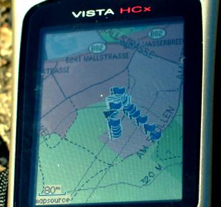
Abb. 02: GPS-Empfänger. Die
Karte stellt die per Knopfdruck protokollierten Punkte mit einem
kleinen Fähnchen dar.
GPS receiver. The map presents the marked points with a small tag. (FB) |
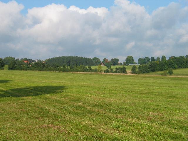
Die Hochfläche um Clausthal-Zellerfeld herum ist nur wenig bewaldet. Die freien großen Wiesenflächen werden von den Bauern genutzt.
Südlich von Clausthal entspringt der Hasenbach. Wie so viele andere Bäche fließt sein Wasser in einen der vielen künstlichen Speicherteiche aus der aktiven Bergbauzeit, die heute als Erholungsgebiete dienen.
The area
around Clausthal Zellerfeld is scarcely wooded. The
free large meadow surfaces are used by the farmers.
South of Clausthal there is the spring of the brook Hasenbach. As so many other brooks its water flow into one of the many artificial storage ponds from the active mining time, which serve today as recreation areas.
South of Clausthal there is the spring of the brook Hasenbach. As so many other brooks its water flow into one of the many artificial storage ponds from the active mining time, which serve today as recreation areas.
Im Jahre 2009 wurde eine der Hauptlinien auf diesen Wiesenflächen erneut verfolgt. Der Vergleich bestätigt die Daten von 2008
In the year 2009 one of the main lines on these meadow surfaces was again pursued. The comparison confirms the data of 2008
geologie-003
 |
| Abb. 03: Blick von Süden an
der B 241 nach Nord-Osten (etwa bei Punkt 220). Etwas rechts der
Bildmitte steht ein Baum mit beginnender Herbstfärbung. Am rechten
Bildrand endet eine Baumkette. Hier steht ebenfalls ein Baum mit
bereits gelben Blättern (Punkt 182 bzw. 341) View of the south at B 241 after north-east (approximately at point 220). Something on the right of the picture center a tree stands with beginning of autumn colouring. At the right contour a tree chain ends. Here stands likewise a tree with already yellow leaves (point 182 resp. 341) (FB) |
 |
| Abb. 03a: Die Wiesen
südlich von Clausthal, links verläuft die B241. Horizontal
zieht sich durch das Bild eine Baum- und Gebüschkette. The meadows south of Clausthal, left is the B241. Horizontal in the center of the picture there is a chain of tree and a bushes. (FB) |
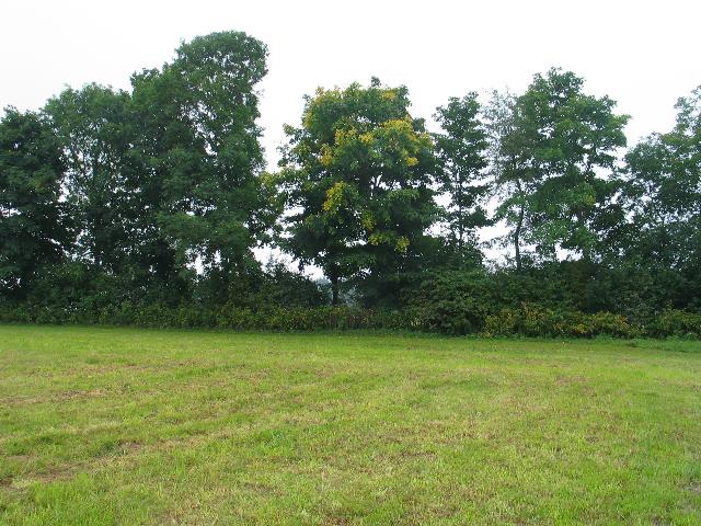 |
| Abb. 04: Der Baum mit den gelben
Blättern innerhalb der Baumkette liegt hinter Punkt 182 und vor
Punkt 341.
The tree with the yellow leaves lies within the tree chain behind point 182 and before point 341. (FB) |
Luftbild http://maps.live.de/LiveSearch.LocalLive interaktives Luftbild mit Google Earth hasenbach-wiese-003.kmz |
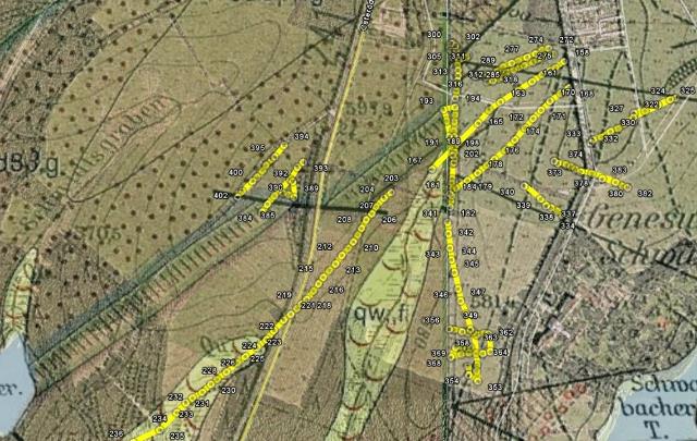 |
| Abb. 06:
Clausthaler Hochfläche mit Wiesen, Wald und Teichen, südlich
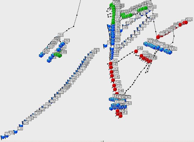
von Clausthal Eingetragen sind erspürte Wegepunkte mit der zugehörigen Benennung. Die Punktekette diagonal durch das Bild von rechts oben nach links unten stammt von mehreren Meßgängen an unterschiedlichen Tagen. Start für den Beginn der Beobachtung waren einige Bäume mit früher Herbstfärbung (Punkte Nr. 158 und 168, rechts oben). Im Bereich südlich von Punkt 193 zieht sich eine Störung von Norden nach Süden durch, die sich durch einen gelbgefärbten Baum bei Punkt 183 bemerkbar gemacht hat. Durch Überlagerung der historischen geologischen Karten lassen sich nun Beziehungen zwischen den gespürten Linien und bekannten Strukturen ableiten. In diesem Ausschnitt treffen in der Bildmitte zwei Karten mit ihren Rändern aufeinander, die offensichtlich von unterschiedlichen Autoren stammen.
The area south of Clausthal with meadows, forest and ponds Peceived positions are registered with the associated designation. The chain of points goes diagonally by the picture from on the top right to the left down and arises from several measuring courses on different days. Start for the beginning of the observation were some trees with early autumn colouring (points No. 158 and 168, on the top right). Within the range south of point 193 a disturbance from the north goes through to the south, which became apparent with a yellow-colored tree at point 183. By overlay of the historical geological maps relations between the perceived lines and the known structures can be derive. In this cutout two maps meet one another with their edges in the picture, which come obviously from different authors. * With the word " Genesung" (right) the direction consists * left above the yellow sign 241 the directions of the crossing disturbances agrees. Also the width of the diagonally running band coincides with the indication in the map. (FB, Geologische Karte von Niedersachsen, 1912, 1:25000) |
 |
| Abb. 07:
Darstellung der markierten Punkte mit dem Programm MapSource:
Punktsymbol und Name
Plot of the marked positions by the program MapSource, symbol and name (FB) |
Liste der markierten Punkte, Aufteilung nach einzelnen Zeitabschnitten
Name, Datum Uhrzeit, Koordinate Geländehöhe
Abschnitt 1, Dauer 5 Minuten elapsed time
158 21-SEP-08 9:02:02 N51 47 41.2 E10 20 09.2 581 m
159 21-SEP-08 9:02:26 N51 47 40.7 E10 20 08.2 588 m
160 21-SEP-08 9:02:56 N51 47 40.2 E10 20 06.5 590 m
161 21-SEP-08 9:03:22 N51 47 39.6 E10 20 05.3 588 m
162 21-SEP-08 9:03:54 N51 47 39.0 E10 20 03.6 586 m
163 21-SEP-08 9:04:30 N51 47 38.1 E10 20 01.5 584 m
164 21-SEP-08 9:05:02 N51 47 37.5 E10 20 00.2 584 m
165 21-SEP-08 9:05:47 N51 47 36.6 E10 19 58.8 582 m
166 21-SEP-08 9:06:39 N51 47 35.0 E10 19 56.3 581 m
167 21-SEP-08 9:07:42 N51 47 33.1 E10 19 53.3 579 m
Abschnitt 2, Dauer 9 Minuten elapsed time
168 21-SEP-08 9:16:11 N51 47 39.2 E10 20 09.7 595 m
169 21-SEP-08 9:16:40 N51 47 38.8 E10 20 08.8 593 m
170 21-SEP-08 9:17:11 N51 47 38.2 E10 20 07.5 593 m
171 21-SEP-08 9:17:39 N51 47 37.5 E10 20 06.4 591 m
172 21-SEP-08 9:18:05 N51 47 36.9 E10 20 05.5 590 m
173 21-SEP-08 9:18:30 N51 47 36.2 E10 20 04.5 589 m
174 21-SEP-08 9:19:01 N51 47 35.3 E10 20 03.2 588 m
175 21-SEP-08 9:19:30 N51 47 34.5 E10 20 02.1 587 m
176 21-SEP-08 9:19:58 N51 47 33.9 E10 20 00.8 586 m
177 21-SEP-08 9:20:18 N51 47 33.4 E10 19 59.9 585 m
178 21-SEP-08 9:20:40 N51 47 32.8 E10 19 58.8 584 m
179 21-SEP-08 9:21:06 N51 47 32.3 E10 19 57.5 583 m
180 21-SEP-08 9:21:33 N51 47 31.7 E10 19 56.2 581 m
181 21-SEP-08 9:21:50 N51 47 31.3 E10 19 55.4 581 m
182 21-SEP-08 9:24:05 N51 47 30.3 E10 19 55.5 582 m
183 21-SEP-08 9:24:22 N51 47 30.8 E10 19 55.5 581 m
184 21-SEP-08 9:24:35 N51 47 31.2 E10 19 55.6 581 m
185 21-SEP-08 9:25:31 N51 47 31.6 E10 19 55.7 582 m
186 21-SEP-08 9:26:13 N51 47 32.1 E10 19 55.6 582 m
187 21-SEP-08 9:26:49 N51 47 32.4 E10 19 55.7 582 m
188 21-SEP-08 9:28:51 N51 47 33.6 E10 19 55.7 582 m
189 21-SEP-08 9:29:12 N51 47 34.1 E10 19 55.8 583 m
190 21-SEP-08 9:29:36 N51 47 34.8 E10 19 55.5 584 m
191 21-SEP-08 9:30:02 N51 47 35.6 E10 19 55.3 586 m
192 21-SEP-08 9:30:38 N51 47 36.7 E10 19 55.0 588 m
193 21-SEP-08 9:31:07 N51 47 37.6 E10 19 54.6 591 m
194 21-SEP-08 9:32:48 N51 47 37.7 E10 19 56.0 590 m
195 21-SEP-08 9:33:07 N51 47 37.2 E10 19 56.0 589 m
196 21-SEP-08 9:33:25 N51 47 36.7 E10 19 56.0 588 m
197 21-SEP-08 9:33:51 N51 47 36.0 E10 19 55.9 587 m
198 21-SEP-08 9:34:09 N51 47 35.5 E10 19 56.0 586 m
199 21-SEP-08 9:34:25 N51 47 35.1 E10 19 56.0 585 m
200 21-SEP-08 9:34:47 N51 47 34.4 E10 19 56.0 584 m
201 21-SEP-08 9:35:03 N51 47 33.9 E10 19 56.0 583 m
202 21-SEP-08 9:35:14 N51 47 33.6 E10 19 55.9 582 m
Abschnitt 3, Dauer 6 Minuten elapsed time
203 21-SEP-08 9:54:47 N51 47 31.4 E10 19 48.4 582 m
204 21-SEP-08 9:55:16 N51 47 31.0 E10 19 47.5 582 m
205 21-SEP-08 9:55:43 N51 47 30.3 E10 19 46.5 582 m
206 21-SEP-08 9:56:04 N51 47 29.8 E10 19 46.0 582 m
207 21-SEP-08 9:56:24 N51 47 29.4 E10 19 45.3 583 m
208 21-SEP-08 9:56:57 N51 47 28.7 E10 19 44.8 581 m
209 21-SEP-08 9:57:18 N51 47 28.2 E10 19 44.3 581 m
210 21-SEP-08 9:57:36 N51 47 27.7 E10 19 43.8 581 m
211 21-SEP-08 9:57:53 N51 47 27.2 E10 19 43.2 581 m
212 21-SEP-08 9:58:15 N51 47 26.7 E10 19 42.4 580 m
213 21-SEP-08 9:58:36 N51 47 26.1 E10 19 41.7 580 m
214 21-SEP-08 9:58:55 N51 47 25.6 E10 19 40.9 580 m
215 21-SEP-08 9:59:19 N51 47 25.1 E10 19 40.2 580 m
216 21-SEP-08 9:59:39 N51 47 24.6 E10 19 39.6 580 m
217 21-SEP-08 9:59:58 N51 47 24.0 E10 19 39.0 580 m
218 21-SEP-08 10:00:21 N51 47 23.4 E10 19 38.2 580 m
219 21-SEP-08 10:00:38 N51 47 23.1 E10 19 37.6 580 m
Abschnitt 4, Dauer 18 Minuten elapsed time
220 21-SEP-08 16:15:20 N51 47 22.7 E10 19 37.0 573 m
221 21-SEP-08 16:15:44 N51 47 22.3 E10 19 36.3 573 m
222 21-SEP-08 16:16:00 N51 47 21.9 E10 19 35.4 573 m
223 21-SEP-08 16:16:34 N51 47 21.1 E10 19 34.2 572 m
224 21-SEP-08 16:17:02 N51 47 20.4 E10 19 33.3 569 m
225 21-SEP-08 16:17:29 N51 47 19.8 E10 19 32.2 568 m
226 21-SEP-08 16:18:01 N51 47 19.1 E10 19 30.8 567 m
227 21-SEP-08 16:18:25 N51 47 18.7 E10 19 29.8 566 m
228 21-SEP-08 16:18:58 N51 47 18.0 E10 19 28.5 564 m
229 21-SEP-08 16:19:33 N51 47 17.4 E10 19 27.4 564 m
230 21-SEP-08 16:19:59 N51 47 17.1 E10 19 26.6 563 m
231 21-SEP-08 16:20:39 N51 47 16.5 E10 19 25.6 563 m
232 21-SEP-08 16:21:20 N51 47 16.0 E10 19 24.4 561 m
233 21-SEP-08 16:21:45 N51 47 15.7 E10 19 23.6 561 m
234 21-SEP-08 16:22:39 N51 47 15.0 E10 19 22.5 560 m
235 21-SEP-08 16:23:54 N51 47 13.7 E10 19 20.5 559 m
236 21-SEP-08 16:26:19 N51 47 12.7 E10 19 17.3 557 m
237 21-SEP-08 16:26:47 N51 47 12.5 E10 19 15.8 558 m
238 21-SEP-08 16:28:14 N51 47 11.9 E10 19 14.2 556 m
239 21-SEP-08 16:28:54 N51 47 11.5 E10 19 13.3 556 m
240 21-SEP-08 16:32:39 N51 47 10.3 E10 19 10.7 554 m
241 21-SEP-08 16:33:04 N51 47 09.9 E10 19 10.2 555 m
Abschnitt 5, Dauer 32 Minuten elapsed time
272 27-SEP-08 17:07:43 N51 47 42.1 E10 20 07.3 391 m
273 27-SEP-08 17:08:42 N51 47 42.0 E10 20 06.5 398 m
274 27-SEP-08 17:09:01 N51 47 41.7 E10 20 05.8 399 m
275 27-SEP-08 17:09:22 N51 47 41.5 E10 20 04.7 400 m
276 27-SEP-08 17:09:45 N51 47 41.2 E10 20 03.7 401 m
277 27-SEP-08 17:10:01 N51 47 41.0 E10 20 02.9 402 m
278 27-SEP-08 17:10:22 N51 47 40.8 E10 20 01.8 404 m
279 27-SEP-08 17:10:42 N51 47 40.5 E10 20 01.1 406 m
280 27-SEP-08 17:11:11 N51 47 40.0 E10 19 59.8 409 m
281 27-SEP-08 17:14:35 N51 47 41.6 E10 19 57.7 434 m
282 27-SEP-08 17:15:07 N51 47 41.5 E10 19 57.4 437 m
283 27-SEP-08 17:15:22 N51 47 41.3 E10 19 56.9 438 m
284 27-SEP-08 17:15:35 N51 47 41.2 E10 19 56.5 439 m
285 27-SEP-08 17:16:40 N51 47 40.1 E10 19 58.5 441 m
286 27-SEP-08 17:17:05 N51 47 40.1 E10 19 58.6 442 m
287 27-SEP-08 17:17:20 N51 47 40.1 E10 19 59.1 443 m
288 27-SEP-08 17:17:32 N51 47 40.1 E10 19 59.3 444 m
289 27-SEP-08 17:18:09 N51 47 40.2 E10 20 00.0 446 m
290 27-SEP-08 17:18:24 N51 47 40.2 E10 20 00.6 447 m
291 27-SEP-08 17:18:50 N51 47 40.3 E10 20 01.6 449 m
292 27-SEP-08 17:19:06 N51 47 40.4 E10 20 02.2 450 m
293 27-SEP-08 17:19:25 N51 47 40.5 E10 20 03.1 451 m
294 27-SEP-08 17:19:45 N51 47 40.7 E10 20 03.8 453 m
295 27-SEP-08 17:20:44 N51 47 40.8 E10 20 04.4 458 m
296 27-SEP-08 17:21:17 N51 47 41.1 E10 20 05.5 463 m
297 27-SEP-08 17:21:35 N51 47 41.3 E10 20 05.9 465 m
298 27-SEP-08 17:22:02 N51 47 41.5 E10 20 06.8 468 m
299 27-SEP-08 17:22:46 N51 47 41.7 E10 20 07.9 472 m
300 27-SEP-08 17:30:57 N51 47 42.5 E10 19 55.6 505 m
301 27-SEP-08 17:31:05 N51 47 42.5 E10 19 55.8 506 m
302 27-SEP-08 17:31:14 N51 47 42.3 E10 19 56.1 506 m
303 27-SEP-08 17:31:21 N51 47 42.2 E10 19 56.1 506 m
304 27-SEP-08 17:31:33 N51 47 42.0 E10 19 55.8 507 m
305 27-SEP-08 17:31:40 N51 47 42.0 E10 19 55.6 507 m
306 27-SEP-08 17:31:49 N51 47 42.1 E10 19 55.3 508 m
307 27-SEP-08 17:31:57 N51 47 42.3 E10 19 55.4 509 m
308 27-SEP-08 17:33:58 N51 47 42.0 E10 19 56.1 514 m
309 27-SEP-08 17:34:16 N51 47 41.5 E10 19 56.2 515 m
310 27-SEP-08 17:34:36 N51 47 40.9 E10 19 56.3 515 m
311 27-SEP-08 17:34:50 N51 47 40.5 E10 19 56.4 515 m
312 27-SEP-08 17:35:05 N51 47 40.1 E10 19 56.4 515 m
313 27-SEP-08 17:35:21 N51 47 39.7 E10 19 56.3 515 m
314 27-SEP-08 17:35:37 N51 47 39.3 E10 19 56.3 514 m
315 27-SEP-08 17:35:54 N51 47 38.9 E10 19 56.2 514 m
316 27-SEP-08 17:36:12 N51 47 38.4 E10 19 56.0 513 m
317 27-SEP-08 17:38:13 N51 47 39.6 E10 19 59.9 518 m
318 27-SEP-08 17:38:34 N51 47 39.7 E10 20 00.6 517 m
319 27-SEP-08 17:38:49 N51 47 39.9 E10 20 01.3 518 m
320 27-SEP-08 17:39:05 N51 47 39.9 E10 20 01.8 519 m
321 27-SEP-08 17:39:22 N51 47 40.1 E10 20 02.4 520 m
Abschnitt 6, Dauer 7 Minuten elapsed time
322 28-SEP-08 15:40:37 N51 47 37.3 E10 20 17.6 563 m
323 28-SEP-08 15:41:20 N51 47 37.5 E10 20 18.9 564 m
324 28-SEP-08 15:41:56 N51 47 37.9 E10 20 20.5 563 m
325 28-SEP-08 15:42:26 N51 47 38.3 E10 20 22.0 563 m
326 28-SEP-08 15:42:42 N51 47 38.4 E10 20 22.6 562 m
327 28-SEP-08 15:45:06 N51 47 37.0 E10 20 17.5 568 m
328 28-SEP-08 15:45:32 N51 47 36.5 E10 20 16.4 569 m
329 28-SEP-08 15:45:51 N51 47 36.2 E10 20 15.7 569 m
330 28-SEP-08 15:46:13 N51 47 35.9 E10 20 14.8 569 m
331 28-SEP-08 15:46:36 N51 47 35.5 E10 20 13.7 570 m
332 28-SEP-08 15:47:09 N51 47 35.3 E10 20 12.7 570 m
333 28-SEP-08 15:47:21 N51 47 35.1 E10 20 12.4 571 m
Abschnitt 7, Dauer 30 Minuten elapsed time
334 28-SEP-08 15:58:55 N51 47 29.7 E10 20 09.6 573 m
335 28-SEP-08 15:59:10 N51 47 29.7 E10 20 09.0 573 m
336 28-SEP-08 15:59:31 N51 47 30.0 E10 20 08.4 574 m
337 28-SEP-08 15:59:45 N51 47 30.2 E10 20 07.6 574 m
338 28-SEP-08 16:00:02 N51 47 30.4 E10 20 07.0 575 m
339 28-SEP-08 16:02:11 N51 47 30.9 E10 20 06.3 576 m
340 28-SEP-08 16:03:19 N51 47 31.9 E10 20 04.4 576 m
341 28-SEP-08 16:06:55 N51 47 29.2 E10 19 55.1 568 m
342 28-SEP-08 16:07:25 N51 47 28.3 E10 19 55.2 568 m
343 28-SEP-08 16:08:00 N51 47 27.2 E10 19 55.4 568 m
344 28-SEP-08 16:08:26 N51 47 26.4 E10 19 55.6 568 m
345 28-SEP-08 16:08:53 N51 47 25.4 E10 19 56.0 568 m
346 28-SEP-08 16:09:27 N51 47 24.2 E10 19 56.4 569 m
347 28-SEP-08 16:09:51 N51 47 23.3 E10 19 56.7 570 m
348 28-SEP-08 16:10:18 N51 47 22.3 E10 19 57.4 570 m
349 28-SEP-08 16:10:50 N51 47 21.2 E10 19 57.9 570 m
350 28-SEP-08 16:13:49 N51 47 21.0 E10 19 58.3 571 m
351 28-SEP-08 16:17:27 N51 47 18.5 E10 19 58.7 571 m
352 28-SEP-08 16:17:46 N51 47 18.0 E10 19 58.6 570 m
353 28-SEP-08 16:18:05 N51 47 17.3 E10 19 58.8 569 m
354 28-SEP-08 16:18:39 N51 47 17.8 E10 19 57.7 571 m
355 28-SEP-08 16:18:58 N51 47 18.4 E10 19 57.6 571 m
356 28-SEP-08 16:22:05 N51 47 21.2 E10 19 55.4 572 m
357 28-SEP-08 16:22:32 N51 47 21.1 E10 19 56.0 573 m
358 28-SEP-08 16:22:51 N51 47 21.0 E10 19 56.9 573 m
359 28-SEP-08 16:23:06 N51 47 20.9 E10 19 57.6 573 m
360 28-SEP-08 16:23:41 N51 47 20.8 E10 19 58.7 573 m
361 28-SEP-08 16:23:58 N51 47 20.9 E10 19 59.6 572 m
362 28-SEP-08 16:24:11 N51 47 20.8 E10 20 00.1 572 m
363 28-SEP-08 16:24:57 N51 47 19.5 E10 20 00.3 571 m
364 28-SEP-08 16:25:15 N51 47 19.4 E10 19 59.4 571 m
365 28-SEP-08 16:25:32 N51 47 19.4 E10 19 58.6 572 m
366 28-SEP-08 16:25:50 N51 47 19.4 E10 19 57.7 572 m
367 28-SEP-08 16:26:08 N51 47 19.3 E10 19 56.8 572 m
368 28-SEP-08 16:26:40 N51 47 19.1 E10 19 55.6 572 m
369 28-SEP-08 16:27:11 N51 47 19.8 E10 19 56.1 573 m
370 28-SEP-08 16:27:32 N51 47 19.8 E10 19 56.9 573 m
371 28-SEP-08 16:27:46 N51 47 19.8 E10 19 57.5 573 m
372 28-SEP-08 16:28:03 N51 47 19.8 E10 19 57.9 572 m
Abschnitt 8, Dauer 6 Minuten elapsed time
373 28-SEP-08 16:42:11 N51 47 33.7 E10 20 08.0 589 m
374 28-SEP-08 16:42:27 N51 47 33.6 E10 20 08.5 590 m
375 28-SEP-08 16:42:47 N51 47 33.4 E10 20 09.4 592 m
376 28-SEP-08 16:43:02 N51 47 33.3 E10 20 10.0 591 m
377 28-SEP-08 16:43:17 N51 47 33.1 E10 20 10.5 592 m
378 28-SEP-08 16:43:35 N51 47 32.9 E10 20 11.2 591 m
379 28-SEP-08 16:44:09 N51 47 32.8 E10 20 12.5 590 m
380 28-SEP-08 16:46:07 N51 47 32.1 E10 20 15.4 588 m
381 28-SEP-08 16:46:26 N51 47 31.9 E10 20 16.2 587 m
382 28-SEP-08 16:46:43 N51 47 31.8 E10 20 16.8 586 m
383 28-SEP-08 16:48:08 N51 47 32.4 E10 20 13.8 591 m
Abschnitt 9, Dauer 9 Minuten elapsed time
384 28-SEP-08 16:58:19 N51 47 29.9 E10 19 32.8 572 m
385 28-SEP-08 16:58:47 N51 47 30.5 E10 19 33.4 584 m
386 28-SEP-08 16:59:21 N51 47 31.1 E10 19 34.3 587 m
387 28-SEP-08 17:00:06 N51 47 31.3 E10 19 35.3 587 m
388 28-SEP-08 17:00:37 N51 47 31.2 E10 19 36.0 586 m
389 28-SEP-08 17:00:56 N51 47 31.0 E10 19 36.7 585 m
390 28-SEP-08 17:01:27 N51 47 32.2 E10 19 36.5 587 m
391 28-SEP-08 17:02:19 N51 47 32.4 E10 19 36.2 587 m
392 28-SEP-08 17:02:58 N51 47 33.3 E10 19 37.1 588 m
393 28-SEP-08 17:03:21 N51 47 33.6 E10 19 37.8 587 m
394 28-SEP-08 17:04:26 N51 47 34.9 E10 19 35.4 588 m
395 28-SEP-08 17:04:58 N51 47 34.0 E10 19 34.3 588 m
396 28-SEP-08 17:05:09 N51 47 33.8 E10 19 33.9 588 m
397 28-SEP-08 17:05:27 N51 47 33.4 E10 19 33.3 589 m
398 28-SEP-08 17:05:41 N51 47 33.0 E10 19 32.9 589 m
399 28-SEP-08 17:06:00 N51 47 32.5 E10 19 32.2 589 m
400 28-SEP-08 17:06:14 N51 47 32.2 E10 19 31.7 588 m
401 28-SEP-08 17:06:44 N51 47 31.5 E10 19 30.4 588 m
402 28-SEP-08 17:07:01 N51 47 31.1 E10 19 29.9 588 m
 |
www.biosensor-physik.de | (c)
05.10.2008 - 04.12.2010 F.Balck |
© BioSensor-Physik 2010 · Impressum