Beobachtungen
Observations:
Bahnhofsunterführungen
Underpassing at railway stations
Unterführungen mit präzise geformten (möglicherweise
auch
noch glatt gekachelten) Wänden zeichnen sich
als "Beugungsbild" mit mehreren spürbaren Bereichen auf dem
Bahnsteig ab.In Herzberg reichen sie bis in den Bereich hinter dem Bahnhofsdach auf dem Bahnsteig (Abb. 01).
In Göttingen (Abb. 02) läßt sich spüren, welche der beiden Unterführungen unter dem Bahnsteig zu beiden Seiten hin durchgängig ist.
Wenn man den Bahnsteig entlang geht, findet man mehrere breite Streifen, die in der Nähe der Unterführung etwa deren Breite haben und nach außen hin noch breiter werden. Auch der Abstand der Streifen voneinander vergrößert sich mit zunehmender Entfernung von der Mitte.
Underpassing
with precicely formed (possibly also still smoothly tiled) walls have
"interference fringes" with several perceiveable sections at the
platform.
In Herzberg
they continue into the range behind the station roof on the platform
(fig. 01).
In Goettingen (fig. 02) it can be perceived, which of the two underpasses under the platform is continuous to both sides.
Going along the platform, one finds several broad strips. Their width is in the proximity of the underpass similar to its and becomes outward still broader. Also the distance of the strips from each other becomes larger with increasing distance from the center.
/Dubrov/ S. 300
«
Archaeology:
In oldest Kiev, an
enginieer and
his team found underground passage-ways two metres broad at a depth
ranging from twenty metres. Ohne hundred bore holes seventy-eight per
cent found their target, while a method to detect the same target using
radio wave instrumentation was much less effective, only twenty-five
per cent. But dowsing, eighty per cent.
»
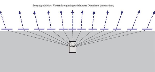 |
| Abb. 01:Schematische Darstellung
der beobachteten "Beugungsbilder" bei Bahnhofsunterführungen. unten: Erdreich mit Unterführung, oben: Luft mit angedeuteten spürbaren Stellen, dazwischen die horizontalen breiten Striche: Bereiche erhöhter Intensität. Mit zunehmendem Abstand vom Zentrum verbreitern sich die spürbaren Streifen und auch die zugehörigen Zwischenräume. Häufig findet man Streifen noch in 100 Meter Entfernung von der Unterführung. Der Hohlraum mit seinen glatten und gut definierten Oberflächen
Möglicherweise sorgt ein großer Unterschied im "Brechungsindex" an der Erdoberfläche (Grenzfläche) dafür, daß auch bei sehr flachen Strahlwinkeln in der Erde die Wellen noch nach oben austreten können. Nach den Regeln der Optik hätte die Luft dann einen größeren "Brechungsindex" als die Erde, und somit wäre die Ausbreitungsgeschwindigkeit in Luft sehr viel langsamer als in der Erde. snellius Auch daß die an der Erdoberfläche beobachtbaren Streifen mit zunehmendem Abstand von der Mitte breiter werden, läßt sich einfach aus geometrischen Bedingungen ableiten. Schematic plot of the observed "interference fringes" with underpassing at railway stations. down: Soil with underpass, above: Air with suggested perceiveable places, between them the horizontal broad lines: Ranges of increased intensity. With increasing distance from the center the perceiveable strips and also the associated gaps widen themselves. One still finds strips frequent into 100 meters distance from the underpass. The cavity with its smooth and well defined surfaces * seems to work as resonator, see also directivity pattern of an antenna * is comparable with thin layers in the optics It possesses - contrary to for example a bulb - an inhomogenous radiation characteristic, i.e. in some directions it radiates less and in other more, as with an interference pattern in the optics. Possibly a large difference in "refraction index" at the earth's surface (boundary surface) ensures that with very flat radiation angles in the earth the waves can withdraw still upward. According to the rules of the optics air would then have a larger "refraction index" as the earth, and thus the propagation speed would be very many slower in air than in the earth. snellius Also that the strips observable at the earth's surface become broader with increasing distance from the center, can be derived simply from geometrical conditions. (FB) |
 |
| Abb. 1a: Unterführung in
Kreiensen, exakt parallele, gekachelte Wände bilden einen guten
Hohlraumresonator. Underpassing at Kreiensen, exact parallel tiled walls operate as a cavity resonator. (FB) |
 |
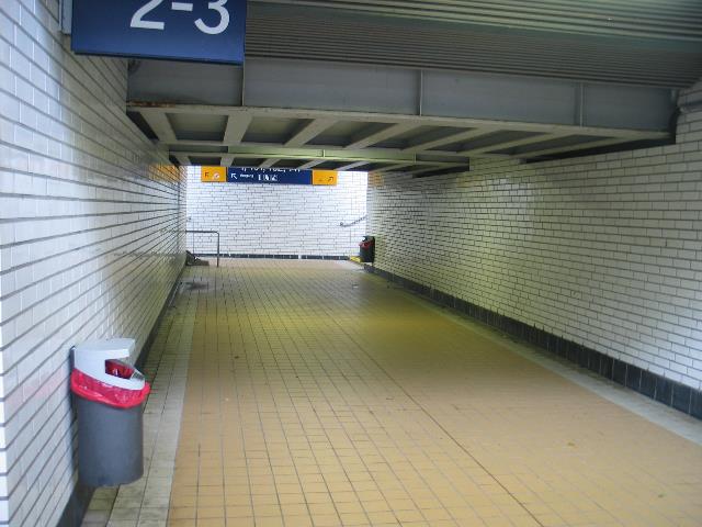
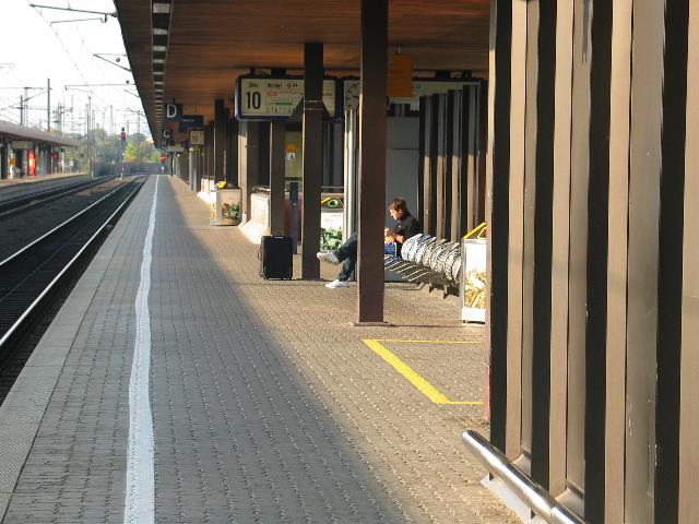
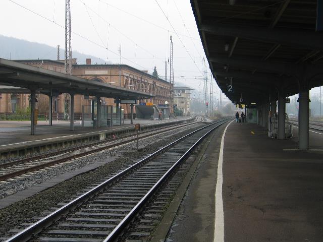
| Abb. 01b: Bahnhof Herzberg am
Harz, die Unterführung unterquert die beiden Gleise, sie hat einen
recheckigen Querschnitt und
gekachelte Wände. Der gläserne Überbau im Bild rechts
deckt die Treppenstufen ab, die Unterführung schließt sich
unmittelbar weiter nach rechts daran an. Im Bereich des überdachten Bahnsteiges lassen sich mehrere (etwa vier) "Beugungsstreifen" spüren. Auch auf dem Bahnsteig am linken Bildrand sind die Streifen zu spüren, und zwar nicht nur in Blickrichtung der Kamera sondern auch in umgekehrter Richtung symmetrisch dazu bezüglich der Unterführung. Station Herzberg am Harz, the underpass underruns the two tracks, it has a rectangle cross section and tiled walls. Under the glass cover in the picture right there are stairway steps, the underpass follows directly further to the right. Within the range of the considered platform several (about four) strips of "interference fringes" can be perceived. Also on the platform at the left contour the strips are to be felt, not only in line of sight of the camera but also in reverse direction symmetrical concerning the underpass. (FB) |
 |
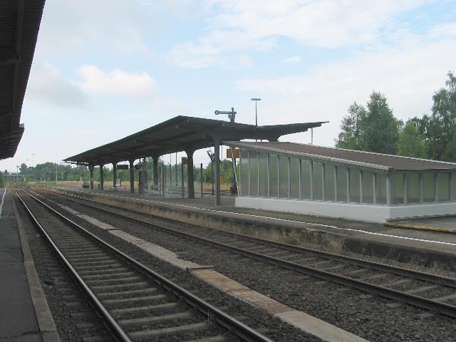
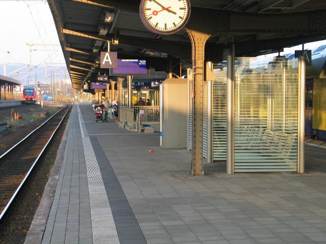
| Abb. 02: Bahnhof Göttingen,
Gleis 10 und 11, nach links führen zwei Unterführungen:
Personenverkehr (Bildmitte, weiße Betonwände) und
Gepäck (vorne rechts, senkrechte braune Blechstreifen). Während die hintere Unterführung alle Gleise unterquert auch in Richtung Lokhalle nach rechts, führt die vordere nur nach links zum Haupteingang. Blick nach Süden. Station Goettingen, track 10 and 11, to the left lead two underpasses: Passenger traffic (picture center, white concrete walls) and luggage (in front right, vertical brown metal strips). While the rear underpass crosses all tracks, the front runs only to the left to the main entrance of the station. View to the south. (FB) |
 |
| Abb. 02a: Bahnhof
Göttingen, Gleis 6, die Unterführung befindet sich in
Bildmitte. Blick nach Norden Station Goettingen, track 6, the underpass is in picture center. View northward (FB) |
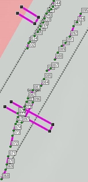 |
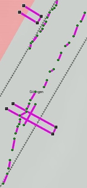
| Abb. 02b
und 02c: Positionen der gespürten "Beugungsmuster", Gleis 10
(nördliches Ende, am "Gepäcktunnel", vorne in Abb. 02) und
Gleis 6. zum Größenvergleich: Die Strecke 068 bis 095
ist 191 Meter lang. Bei den Punkten 068 bis 073 für Gleis 6 scheint eine größere Ungenauigkeit der Koordinaten vorzuliegen. Die kurzen Verbindungslinien markieren jeweils Bereiche erhöhter Intensität. Die langen Linien skizzieren die Positionen der beiden Unterführungen. (FB) Positions of the felt "interference fringes", Track 10 (northern end, " luggage tunnel" , in front in fig. 02) and track 6. to the size comparison: The distance 068 to 095 is 191 meters long. At the points 068 to 073 for track 6 a larger inaccuracy of the coordinates seems to be present. The short connecting lines mark in each case ranges of increased intensity. The long lines outline the positions of the two underpasses. Name Datum / Zeit Position geologie-001 032 07-NOV-08 13:51:55 N51 32.242 E9 55.566 524 m 033 07-NOV-08 13:52:03 N51 32.244 E9 55.567 524 m 034 07-NOV-08 13:52:08 N51 32.245 E9 55.568 524 m 035 07-NOV-08 13:52:21 N51 32.249 E9 55.573 524 m 036 07-NOV-08 13:52:27 N51 32.251 E9 55.575 524 m 037 07-NOV-08 13:52:33 N51 32.252 E9 55.577 524 m 038 07-NOV-08 13:52:40 N51 32.254 E9 55.578 523 m 039 07-NOV-08 13:52:48 N51 32.256 E9 55.580 523 m 040 07-NOV-08 13:52:54 N51 32.258 E9 55.581 523 m 041 07-NOV-08 13:53:02 N51 32.261 E9 55.583 524 m 042 07-NOV-08 13:53:09 N51 32.263 E9 55.586 523 m 043 07-NOV-08 13:53:16 N51 32.264 E9 55.587 523 m 044 07-NOV-08 13:53:23 N51 32.265 E9 55.589 523 m 045 07-NOV-08 13:53:32 N51 32.268 E9 55.590 523 m 068 08-NOV-08 15:52:31 N51 32.168 E9 55.543 121 m 069 08-NOV-08 15:52:40 N51 32.173 E9 55.546 122 m 070 08-NOV-08 15:52:48 N51 32.176 E9 55.547 122 m 071 08-NOV-08 15:52:57 N51 32.181 E9 55.549 122 m 072 08-NOV-08 15:53:06 N51 32.186 E9 55.551 122 m 073 08-NOV-08 15:53:14 N51 32.192 E9 55.553 122 m 074 08-NOV-08 15:53:19 N51 32.195 E9 55.554 122 m 075 08-NOV-08 15:53:28 N51 32.199 E9 55.555 122 m 076 08-NOV-08 15:53:37 N51 32.200 E9 55.557 122 m 077 08-NOV-08 15:53:46 N51 32.203 E9 55.558 122 m 078 08-NOV-08 15:53:55 N51 32.205 E9 55.557 123 m 079 08-NOV-08 15:54:05 N51 32.207 E9 55.563 122 m 080 08-NOV-08 15:54:11 N51 32.209 E9 55.563 122 m 081 08-NOV-08 15:54:18 N51 32.211 E9 55.565 123 m 082 08-NOV-08 15:54:25 N51 32.213 E9 55.566 123 m 083 08-NOV-08 15:54:34 N51 32.218 E9 55.571 123 m 084 08-NOV-08 15:54:44 N51 32.220 E9 55.578 122 m 085 08-NOV-08 15:54:54 N51 32.224 E9 55.581 123 m 086 08-NOV-08 15:55:04 N51 32.229 E9 55.584 123 m 087 08-NOV-08 15:55:14 N51 32.230 E9 55.587 123 m 088 08-NOV-08 15:55:28 N51 32.235 E9 55.591 123 m 089 08-NOV-08 15:55:38 N51 32.239 E9 55.594 123 m 090 08-NOV-08 15:55:50 N51 32.243 E9 55.597 123 m 091 08-NOV-08 15:56:00 N51 32.245 E9 55.601 123 m 092 08-NOV-08 15:56:12 N51 32.248 E9 55.604 124 m 093 08-NOV-08 15:56:25 N51 32.254 E9 55.608 122 m 094 08-NOV-08 15:56:38 N51 32.256 E9 55.611 123 m 095 08-NOV-08 15:56:49 N51 32.261 E9 55.614 123 m 096 08-NOV-08 15:59:50 N51 32.211 E9 55.571 123 m 097 08-NOV-08 16:00:10 N51 32.200 E9 55.561 123 m |
|
Interaktives Luftbild mit Google Earth Abb. 02c: Göttinger Bahnhof
aus der Luft mit "Beugungsmustern" der beiden Unterführungen
Göttinger station from air with
" Beugungsmustern" the two underpasses.
(FB)
|
 |
| Abb. 03: Im Bahnhof von
Kreiensen läßt sich das Muster der Unterführung, eine
periodische Struktur, bis
hierher spüren. Ein Eingang zur Unterführung ist etwas links
der Bildmitte zu sehen. Sie unterquert die beiden Gleise nach rechts.
(FB) In the station of Kreiensen the pattern of the underpass can be perceived until here, a periodic structure. The entrance for the underpass is to be seen something on the left of the picture center. It underruns the two tracks to the right. |
Interaktives
Luftbild
mit
Google
Earth
Abb. 03b: "Beugungsmuster" der
Unterführung im Bahnhof von Kreiensen, Gleis 2
"interference fringes" of the underpassing at Station of Kreiensen, track 2 (FB) |
 |
| Abb. 03c: Bahnhof Kreiensen,
Gleis 2 Die beiden langen Linien markieren die Position der Unterführung. Der Abstand von 017 bis 031 beträgt 135 Meter Koordinaten des "Beugungsbildes" der Unterführung , GPS Die kurzen Verbindungslinien markieren jeweils Bereiche erhöhter Intensität. Station Kreiensen, track 2 The two long lines mark the position of the underpass. The distance from 017 to 031 amounts to 135 meters Coordinates "interference fringes" of the underpass, GPS The short connecting lines mark in each case ranges of increased intensity. Name Datum / Zeit Position geologie-001 002 07-NOV-08 13:06:20 N51 51.071 E9 58.029 525 m 003 07-NOV-08 13:06:29 N51 51.069 E9 58.032 525 m 004 07-NOV-08 13:06:35 N51 51.068 E9 58.036 525 m 005 07-NOV-08 13:06:43 N51 51.066 E9 58.039 525 m 006 07-NOV-08 13:06:49 N51 51.064 E9 58.042 525 m 007 07-NOV-08 13:06:57 N51 51.063 E9 58.049 525 m 008 07-NOV-08 13:07:05 N51 51.061 E9 58.053 525 m 009 07-NOV-08 13:07:11 N51 51.059 E9 58.056 525 m 010 07-NOV-08 13:07:23 N51 51.058 E9 58.059 525 m 011 07-NOV-08 13:07:29 N51 51.056 E9 58.063 525 m 012 07-NOV-08 13:07:36 N51 51.055 E9 58.067 525 m 013 07-NOV-08 13:07:45 N51 51.052 E9 58.072 525 m 014 07-NOV-08 13:07:51 N51 51.051 E9 58.076 525 m 015 07-NOV-08 13:07:59 N51 51.048 E9 58.079 525 m 016 07-NOV-08 13:08:05 N51 51.046 E9 58.083 525 m 017 07-NOV-08 13:08:13 N51 51.044 E9 58.087 525 m 018 07-NOV-08 13:09:45 N51 51.068 E9 58.036 521 m 019 07-NOV-08 13:09:54 N51 51.070 E9 58.033 521 m 020 07-NOV-08 13:10:04 N51 51.072 E9 58.031 522 m 021 07-NOV-08 13:10:11 N51 51.072 E9 58.028 522 m 022 07-NOV-08 13:10:18 N51 51.074 E9 58.025 523 m 023 07-NOV-08 13:10:25 N51 51.076 E9 58.021 523 m 024 07-NOV-08 13:10:31 N51 51.078 E9 58.017 523 m 025 07-NOV-08 13:10:39 N51 51.078 E9 58.013 522 m 026 07-NOV-08 13:10:47 N51 51.080 E9 58.009 522 m 027 07-NOV-08 13:10:56 N51 51.083 E9 58.006 522 m 028 07-NOV-08 13:11:02 N51 51.084 E9 58.003 522 m 029 07-NOV-08 13:11:09 N51 51.085 E9 58.001 522 m 030 07-NOV-08 13:11:17 N51 51.087 E9 57.998 523 m 031 07-NOV-08 13:11:27 N51 51.089 E9 57.994 523 m |
 |
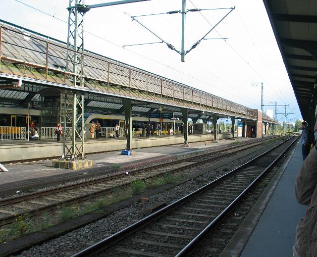
| Abb. 04: Die Unterführung
im Bahnhof von Lüneburg ist als periodische Struktur auch bis hier
zu spüren. Die Unterführung
unterquert alle Gleise nach rechts und links. Gleis 5, Blick nach
Süden (FB) The underpass in the station of Lueneburg is to be felt as periodic structure also until here. The underpass underruns all tracks to the right and left. Track 5, view to the south interaktives Luftbild mit Google Earth lueneburg-bahnhof-002.kmz |
 |
| Abb. 04a: Blick in die
Unterführung, von Gleis5 in Richtung Osten View in to the underpassing, Track 5, view eastward (FB) |
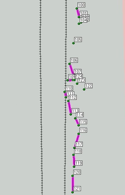 |
| Abb. 4b: Gespürte
Positionen, "Beugungsbild" der Unterführung auf Gleis 5 in
Lüneburg. Die Unterführung befindet sich unterhalb der Punkte
122 bis 124. Die Abstand von Punkt 100 bis 120 beträgt 110
Meter. GPS-Genauigkeit etwa 10 Meter. Grobe, oberflächliche
Beobachtung in etwa 5 Minuten. (FB) perceived positions, "interference fringes" of the underpass on track 5 in Lueneburg. The underpass is below the points 122 to 124. The distance from point 100 to 120 amounts to 110 meters. GPS accuracy of about 10 meters. Rough, superficial observation in approximately 5 minutes. 100 15-NOV-08 11:05:16 N53 15.007 E10 25.207 537 m 101 15-NOV-08 11:05:25 N53 15.004 E10 25.209 537 m 102 15-NOV-08 11:05:34 N53 15.003 E10 25.210 537 m 103 15-NOV-08 11:05:44 N53 15.002 E10 25.210 537 m 104 15-NOV-08 11:05:53 N53 15.002 E10 25.209 537 m 105 15-NOV-08 11:06:03 N53 14.995 E10 25.205 537 m 106 15-NOV-08 11:06:10 N53 14.988 E10 25.203 537 m 107 15-NOV-08 11:06:19 N53 14.984 E10 25.205 537 m 108 15-NOV-08 11:06:30 N53 14.982 E10 25.205 537 m 109 15-NOV-08 11:06:36 N53 14.982 E10 25.202 538 m 110 15-NOV-08 11:06:43 N53 14.978 E10 25.200 539 m 111 15-NOV-08 11:06:50 N53 14.976 E10 25.201 538 m 112 15-NOV-08 11:06:58 N53 14.974 E10 25.202 537 m 113 15-NOV-08 11:07:07 N53 14.970 E10 25.204 537 m 114 15-NOV-08 11:07:15 N53 14.968 E10 25.206 537 m 115 15-NOV-08 11:07:26 N53 14.966 E10 25.208 537 m 116 15-NOV-08 11:07:34 N53 14.963 E10 25.208 537 m 117 15-NOV-08 11:07:44 N53 14.958 E10 25.206 537 m 118 15-NOV-08 11:07:52 N53 14.955 E10 25.205 537 m 119 15-NOV-08 11:08:01 N53 14.951 E10 25.206 537 m 120 15-NOV-08 11:08:11 N53 14.948 E10 25.205 536 m 121 15-NOV-08 11:08:22 N53 14.942 E10 25.205 537 m 122 15-NOV-08 11:09:48 N53 14.979 E10 25.212 537 m 123 15-NOV-08 11:10:03 N53 14.981 E10 25.208 537 m 124 15-NOV-08 11:10:10 N53 14.982 E10 25.206 537 m |
 |
| Abb. 05: In Oldenburg (Old.)
gibt es einerseits die Fußgängerunterführung,
andererseits aber auch zwei Unterführungen für Gepäck
und
andere Transportgüter (roter Ziegelsteinbau im Bild rechts). Beim Abschreiten entlang von Gleis 1 (rechts im Bild) zeigt sich eine nicht streng periodische Struktur, offensichtlich bedingt durch die Geschäftsräume neben der Fußgängerunterführung. Bei Gleis 3 (links im Bild ) lassen sich periodische Strukturen symmetrisch zur Fußgängerunterführung spüren, die allerdings im Bereich des Ziegelbaus durch dessen Auswirkung überdeckt sind. In Oldenburg (Old.) there are on the one hand the pedestrian subway, on the other hand two underpasses for luggage and other merchandise (red brick construction in the picture right). When walking down along track 1 (right in the picture) a not strictly periodic structure was found, obviously established by the business premises beside the pedestrian subway. With track 3 (left in the picture) periodic structures can be felt symmetrically to the pedestrian subway, which are covered by its effect however in the range of the building of bricks. (FB) |
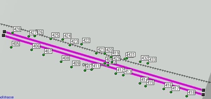 |
| Abb. 05a: Oldenburg, Markierte Echos der Unterführung am Gleis 1 (unten) von 405/406 bis 417/418 (jeweils ungerade bis gerade Zahl) und Gleis 2 (oben). Die Abdeckung durch das Bahnhofsdach hat die Positionsbestimmung teilweise beeinflußt. Ab Markierung 420 bis 428 scheint die Reihenfolge für Beginn und Ende vertauscht zu sein. Die lila Linien mit Länge 200 m sollen das Gleis 1 andeuten. Oldenburg, Marked echoes of the underpass at the track 1 (down) from 405/406 to 417/418 (oddly in each case until even number) and track 2 (above). The cover by the station roof partly affected the positioning. Starting from marking 420 to 428 the sequence for beginning and end seems to be exchanged. The purple lines with length 200 m are to suggest the track 1. (FB) |
| Name, Datum Uhrzeit, Koordinate rel. Höhe? geologie-001 403 02-OKT-08 14:08:33 N53 08.638 E8 13.361 562 m 404 02-OKT-08 14:08:43 N53 08.639 E8 13.358 563 m 405 02-OKT-08 14:10:38 N53 08.648 E8 13.278 563 m 406 02-OKT-08 14:11:04 N53 08.646 E8 13.295 562 m 407 02-OKT-08 14:11:21 N53 08.644 E8 13.305 563 m 408 02-OKT-08 14:11:44 N53 08.640 E8 13.320 563 m 409 02-OKT-08 14:11:58 N53 08.637 E8 13.329 563 m 410 02-OKT-08 14:12:20 N53 08.636 E8 13.341 563 m 411 02-OKT-08 14:12:32 N53 08.636 E8 13.346 563 m 412 02-OKT-08 14:13:00 N53 08.634 E8 13.367 563 m 413 02-OKT-08 14:13:14 N53 08.633 E8 13.374 563 m 414 02-OKT-08 14:13:37 N53 08.629 E8 13.388 562 m 415 02-OKT-08 14:13:48 N53 08.627 E8 13.393 562 m 416 02-OKT-08 14:14:09 N53 08.626 E8 13.409 563 m 417 02-OKT-08 14:14:23 N53 08.624 E8 13.415 563 m 418 02-OKT-08 14:14:43 N53 08.622 E8 13.428 564 m 419 02-OKT-08 14:19:06 N53 08.642 E8 13.363 563 m 420 02-OKT-08 14:19:18 N53 08.644 E8 13.358 563 m 421 02-OKT-08 14:19:27 N53 08.645 E8 13.351 563 m 422 02-OKT-08 14:19:42 N53 08.649 E8 13.338 563 m 423 02-OKT-08 14:19:53 N53 08.649 E8 13.328 563 m 424 02-OKT-08 14:20:06 N53 08.652 E8 13.322 564 m 425 02-OKT-08 14:20:18 N53 08.652 E8 13.311 564 m 426 02-OKT-08 14:20:33 N53 08.653 E8 13.298 563 m 427 02-OKT-08 14:20:42 N53 08.653 E8 13.293 563 m 428 02-OKT-08 14:20:58 N53 08.655 E8 13.279 563 m 429 02-OKT-08 14:22:26 N53 08.640 E8 13.364 563 m 430 02-OKT-08 14:22:42 N53 08.642 E8 13.375 563 m 431 02-OKT-08 14:22:47 N53 08.642 E8 13.377 563 m 432 02-OKT-08 14:23:03 N53 08.640 E8 13.388 564 m 433 02-OKT-08 14:23:13 N53 08.639 E8 13.395 563 m |
|
interaktives Luftbild mit Google Earth Abb. 06: Bahnhof in Oldenburg
(Old.) Markierte Echos der Unterführung am Gleis 1 (unten) von
405/406 bis 417/418 (jeweils ungerade bis gerade Zahl). Die Abdeckung
durch das Bahnhofsdach hat die Positionsbestimmung teilweise
beeinflußt. Ab Markierung 420 bis 428 scheint die Reihenfolge
für Beginn und Ende vertauscht zu sein.
Station in Oldenburg (Old.) Marked echoes of the underpass at the track 1 (down) from 405/406 to 417/418 (oddly in each case until even number). The cover by the station roof partly affected the positioning. Starting from marking 420 to 428 the sequence for beginning and end seems to be exchanged. (FB) |
 |
| Abb. 07: Bahnhof Tübingen,
entlang des linken Gleises lassen sich periodische Strukturen
spüren, die offensichtlich durch die Unterführung bedingt
sind. Allerdings ist die Form der Unterführung nicht
einheitlich. Senkrechte Begrenzungswände hat sie nur in
unmittelbarer Nähe
der Gleise. Im mittleren Bereich des Bahnsteiges
nach vorne und hinten ist jeweils eine Fußgängertreppe.
Sowohl die senkrechten Wände im Gleisbereich als auch
die Stufen werden in größerer Entfernung ein
überlagertes Bild ergeben. Station Tuebingen. Periodic structures can be felt along the left track, which are obviously due to the underpass. However the geometry of the underpass is not uniform. Vertical limiting walls are only in direct proximity of the tracks. Iin the middle range of the platform are pedestrian stairs. The perceiveable pattern at larger distance will result in an overlay of the effects of the vertical walls and the stairs. (FB) |
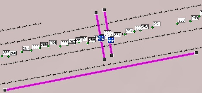 |
| Abb. 07a: Bahnhof Tübingen.
Einige mit GPS markierte Positionen, bei denen
ein Wechsel der gespürten Intensität gefunden wurde. Die
beiden Punkte 270 und 271 zeigen die Lage der Unterführung
an. Die Punkte auf der linken Seite gehören jeweils
paarweise zu einem "Echo" der Unterführung, 269-268, 267-266 usw..
Auf der rechten Seite beispielsweise beim Punkt 250 war die
Identifizierung schwieriger. Die lange lila Linie hat eine Länge
von 200 m. Station Tuebingen. Some points are marked with GPS. At these positions a change in the perceived intensity was found. Both the points 270 and 271 are at the position of the underpassing. Points on the left side belong in pairs always to one "echo" of the underpass, 269-268, 267-266 etc.. On the right side for example at the point 250 the identification was more difficult. The long purple line has a length of 200 m. (FB) |
| Name, Datum
Uhrzeit, Koordinate
rel.
Höhe?
geologie-001 244 27-SEP-08 8:43:16 N48 30.954 E9 03.432 337 m 245 27-SEP-08 8:43:39 N48 30.953 E9 03.419 330 m 246 27-SEP-08 8:43:54 N48 30.953 E9 03.413 327 m 247 27-SEP-08 8:44:08 N48 30.951 E9 03.405 326 m 248 27-SEP-08 8:44:18 N48 30.952 E9 03.400 327 m 249 27-SEP-08 8:45:14 N48 30.949 E9 03.392 327 m 250 27-SEP-08 8:45:33 N48 30.947 E9 03.381 327 m 251 27-SEP-08 8:46:10 N48 30.945 E9 03.361 326 m 252 27-SEP-08 8:46:27 N48 30.944 E9 03.351 327 m 253 27-SEP-08 8:46:40 N48 30.943 E9 03.346 327 m 254 27-SEP-08 8:47:05 N48 30.941 E9 03.338 327 m 255 27-SEP-08 8:47:37 N48 30.940 E9 03.324 326 m 256 27-SEP-08 8:47:51 N48 30.938 E9 03.319 326 m 257 27-SEP-08 8:47:59 N48 30.938 E9 03.316 326 m 258 27-SEP-08 8:48:08 N48 30.938 E9 03.311 326 m 259 27-SEP-08 8:48:16 N48 30.937 E9 03.307 326 m 260 27-SEP-08 8:48:49 N48 30.937 E9 03.299 326 m 261 27-SEP-08 8:49:02 N48 30.937 E9 03.296 327 m 262 27-SEP-08 8:49:13 N48 30.936 E9 03.290 326 m 263 27-SEP-08 8:49:25 N48 30.935 E9 03.284 326 m 264 27-SEP-08 8:49:43 N48 30.935 E9 03.274 326 m 265 27-SEP-08 8:49:57 N48 30.934 E9 03.267 326 m 266 27-SEP-08 8:50:13 N48 30.933 E9 03.260 326 m 267 27-SEP-08 8:50:28 N48 30.932 E9 03.252 326 m 268 27-SEP-08 8:50:48 N48 30.929 E9 03.241 326 m 269 27-SEP-08 8:51:01 N48 30.929 E9 03.235 326 m 270 27-SEP-08 8:52:41 N48 30.939 E9 03.318 326 m 271 27-SEP-08 8:52:54 N48 30.938 E9 03.326 327 m |
interaktives Luftbild mit Google Earth tuebingen-bahnhof.kmz Abb. 08: Der Tübinger Bahnhof aus der Luft. Einige mit GPS markierte Positionen, bei denen ein Wechsel der gespürten Intensität gefunden wurde. Die beiden Punkte 270 und 271 zeigen die Lage der Unterführung an. Die Punkte auf der linken Seite gehören jeweils paarweise zu einem "Echo" der Unterführung, 269 und 268, 267 und 266. Auf der rechten Seite beispielsweise beim Punkt 250 war die Identifizierung schwieriger. Station Tuebingen from the air. Some points are marked with GPS. At these positions a change in the perceived intensity was found. Both the points 270 and 271 are at the position of the underpassing. Points on the left side belong in pairs always to one "echo" of the underpass, 269-268, 267-266 etc.. On the right side for example at the point 250 the identification was more difficult. The long purple line has a length of 200 m. (FB) |
 |
www.biosensor-physik.de | (c)
23.03.2010 F.Balck |
© BioSensor-Physik 2010 · Impressum