Beobachtungen
Observations:
Psi-Track-001, Verfolgen einer Spur, Orientierung,
Fortsetzung
Pursuing of a trace,
orientation, continuation
zum Verteiler Psi-Track und zu den anderen Psi-Track-Seiten psi-track-000
back
to
the main page of psi track
Gosetal
Auf dem Parkplatz am Campingplatz Sennhütte bei Goslar stand das Ziel, das Auto des Autors. N51 53 22.9 E10 23 58.8
The
target: the author's car stood at a parking place near Goslar
http://maps.live.de/LiveSearch.LocalLive?
aktives Luftbild mit Google Earth
psi-track-007-sennhuette.kmz
Oben auf den Bergwiesen in der Nähe vom "HessenKopf" wurden auf der Wiese in drei Versuchen Spuren zum Auto gelegt und per GPS protokolliert.
Der Abstand zum Auto betrug etwa 360 Meter. Bedingt durch die Form des Geländes, war der Standort des Autos von der oberen Wiese nicht einsehbar. Das Gras auf der Wiese war so kurz, daß man die eigenen Fußspuren der Nachbarspuren nicht sehen konnte.
Above on the
mountain meadows in the proximity of " HessenKopf" were put
three different traces to the car and logged by GPS.
The distance to the car amounted to about 360 meters. The location of the car was not observable from the starting point. The grass on the meadow was so short that it was impossible to see the own footprints of the neighbour traces.
The distance to the car amounted to about 360 meters. The location of the car was not observable from the starting point. The grass on the meadow was so short that it was impossible to see the own footprints of the neighbour traces.
Alle Beobachtungen erfolgten nach der natürlichen Methode, d.h. ohne Hilfsmittel wie eine Rute.
Die Koordinaten der gefundenen Positionen wurden nachvollziehbar per GPS mit Datum und Uhrzeit protokolliert.
All
observations were done by the natural method, i.e. without aids like a
rod. The coordinates of the found positions and the walked tracks were
logged replicable by GPS with date and time.
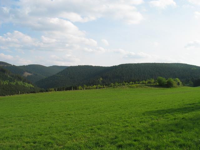 |
| Abb. 01: Blick von der oberen
Wiese, auf der die Spuren gelegt wurden. Im Tal etwa 50 Meter tiefer - von hier aus nicht einsehbar - verläuft die Straße vorbei am Campingplatz Sennhütte. Irgendwo dort befindet sich der gesuchte Parkplatz. View in the direction toward the parking place with the car, which is invisible from here. The traces were laid down on this meadow. The road runs in the valley belows in the proximity of the camping area. (FB) |
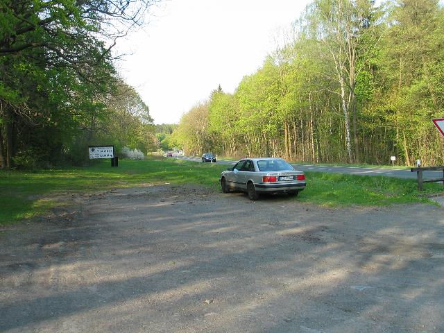 |
| Abb. 02: Das Ziel: das Auto auf
dem Parkplatz am Campingplatz N51 53 22.9 E10 23 58.8. Die Bergwiese
beginnt am linken Hang. The target: the car at the parking place. The meadow begins at the pictures left. (FB) |
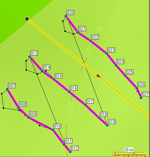 |
| Abb. 03: Die drei Spuren auf
der
Bergwiese. Die lange gelbe Linie markiert die Richtung zum Ziel, das
in 360 Meter Entfernung war. schwarz: Track (gelaufener Weg), grün und lila: markierte Punkte der gespürte Linien in Richtung zum Ziel. Bei jeder Spurensuche war der Startpunkt im Bild links oben jeweils am Sendepunkt (007, 013 und 020). Die schwarzen Linien zeigen, wie auf einem Kreisbogen der Sendepunkt bis zur Spur umrundet wurde. Der Abstand der Spuren voneinander beträgt jeweils mehr als 25 Meter. The three traces on the mountain meadow. The long yellow line marks the direction to the target 360 meters distance. black: track (run way), green and purple: marked points of felt lines toward to the target. With each tracing the starting point was in the picture in each case left above at the sending point (007, 013 and 020). The black lines show, how on a circular arc the sending point was orbited up to the found trace. The distance of the traces from each other amounts to more in each case than 25 meters (FB) |
| Gesamt Dauer 8 Minuten,
Informationen zu den
GPS-Daten: geologie-001 elapsed time 8 minutes
markierte Positionen der Spuren Name, Datum Uhrzeit, Koordinate Geländehöhe/Luftdruck Spur 1 007 25-APR-09 17:31:54 N51 53 28.7 E10 23 43.5 377 m 008 25-APR-09 17:32:18 N51 53 28.3 E10 23 43.9 376 m 009 25-APR-09 17:32:28 N51 53 28.1 E10 23 44.3 377 m 010 25-APR-09 17:33:02 N51 53 27.8 E10 23 45.1 374 m 011 25-APR-09 17:33:14 N51 53 27.5 E10 23 45.5 375 m 012 25-APR-09 17:33:21 N51 53 27.4 E10 23 45.7 377 m Spur 2 013 25-APR-09 17:35:58 N51 53 29.4 E10 23 44.3 377 m 014 25-APR-09 17:36:17 N51 53 29.1 E10 23 44.7 375 m 015 25-APR-09 17:36:28 N51 53 28.9 E10 23 45.1 374 m 016 25-APR-09 17:36:38 N51 53 28.6 E10 23 45.7 374 m 017 25-APR-09 17:36:47 N51 53 28.4 E10 23 46.2 373 m 018 25-APR-09 17:36:57 N51 53 28.1 E10 23 46.7 373 m 019 25-APR-09 17:37:02 N51 53 27.9 E10 23 47.0 373 m Spur 3 020 25-APR-09 17:38:52 N51 53 30.2 E10 23 45.5 374 m 021 25-APR-09 17:39:11 N51 53 29.9 E10 23 46.0 373 m 022 25-APR-09 17:39:21 N51 53 29.7 E10 23 46.4 373 m 023 25-APR-09 17:39:30 N51 53 29.5 E10 23 46.9 371 m 024 25-APR-09 17:39:38 N51 53 29.2 E10 23 47.3 371 m 025 25-APR-09 17:39:45 N51 53 29.0 E10 23 47.6 370 m 026 25-APR-09 17:39:53 N51 53 28.7 E10 23 48.0 370 m 027 25-APR-09 17:39:59 N51 53 28.5 E10 23 48.1 370 m Ziel 028 25-APR-09 17:59:38 N51 53 22.9 E10 23 58.8 319 m |
| 1
25.04.2009 17:31:33 377 m
1 m
0:00:25 0.1 km/h 182°
Wahr N51 53 28.7 E10 23 43.5 2 25.04.2009 17:31:58 377 m 4 m 0:00:03 5 km/h 236° Wahr N51 53 28.7 E10 23 43.5 3 25.04.2009 17:32:01 377 m 9 m 0:00:07 5 km/h 173° Wahr N51 53 28.6 E10 23 43.3 4 25.04.2009 17:32:08 377 m 10 m 0:00:13 3 km/h 99° Wahr N51 53 28.3 E10 23 43.4 5 25.04.2009 17:32:21 376 m 5 m 0:00:05 4 km/h 129° Wahr N51 53 28.3 E10 23 43.9 6 25.04.2009 17:32:26 376 m 7 m 0:00:06 4 km/h 123° Wahr N51 53 28.2 E10 23 44.1 7 25.04.2009 17:32:32 376 m 5 m 0:00:05 4 km/h 129° Wahr N51 53 28.0 E10 23 44.4 8 25.04.2009 17:32:37 376 m 9 m 0:00:16 2 km/h 109° Wahr N51 53 27.9 E10 23 44.6 9 25.04.2009 17:32:53 375 m 12 m 0:00:21 2 km/h 143° Wahr N51 53 27.8 E10 23 45.1 10 25.04.2009 17:33:14 375 m 2 m 0:00:03 3 km/h 138° Wahr N51 53 27.5 E10 23 45.5 11 25.04.2009 17:33:17 377 m 64 m 0:02:23 2 km/h 338° Wahr N51 53 27.5 E10 23 45.6 12 25.04.2009 17:35:40 377 m 3 m 0:00:23 0.5 km/h 227° Wahr N51 53 29.4 E10 23 44.3 13 25.04.2009 17:36:03 377 m 6 m 0:00:05 4 km/h 180° Wahr N51 53 29.3 E10 23 44.2 14 25.04.2009 17:36:08 376 m 8 m 0:00:06 5 km/h 110° Wahr N51 53 29.1 E10 23 44.2 15 25.04.2009 17:36:14 376 m 6 m 0:00:09 2 km/h 69° Wahr N51 53 29.0 E10 23 44.6 16 25.04.2009 17:36:23 376 m 12 m 0:00:08 5 km/h 133° Wahr N51 53 29.1 E10 23 44.9 17 25.04.2009 17:36:31 376 m 8 m 0:00:06 5 km/h 131° Wahr N51 53 28.8 E10 23 45.3 18 25.04.2009 17:36:37 375 m 19 m 0:00:13 5 km/h 131° Wahr N51 53 28.7 E10 23 45.6 19 25.04.2009 17:36:50 374 m 15 m 0:00:15 4 km/h 130° Wahr N51 53 28.3 E10 23 46.4 20 25.04.2009 17:37:05 375 m 77 m 0:01:26 3 km/h 340° Wahr N51 53 27.9 E10 23 47.0 21 25.04.2009 17:38:31 376 m 1 m 0:00:25 0.2 km/h 199° Wahr N51 53 30.3 E10 23 45.6 22 25.04.2009 17:38:56 376 m 4 m 0:00:02 6 km/h 213° Wahr N51 53 30.2 E10 23 45.5 23 25.04.2009 17:38:58 376 m 7 m 0:00:04 6 km/h 168° Wahr N51 53 30.1 E10 23 45.4 24 25.04.2009 17:39:02 376 m 6 m 0:00:05 4 km/h 108° Wahr N51 53 29.9 E10 23 45.5 25 25.04.2009 17:39:07 376 m 4 m 0:00:05 3 km/h 76° Wahr N51 53 29.9 E10 23 45.8 26 25.04.2009 17:39:12 373 m 2 m 0:00:03 3 km/h 131° Wahr N51 53 29.9 E10 23 46.0 27 25.04.2009 17:39:15 374 m 4 m 0:00:03 5 km/h 119° Wahr N51 53 29.9 E10 23 46.1 28 25.04.2009 17:39:18 374 m 19 m 0:00:13 5 km/h 129° Wahr N51 53 29.8 E10 23 46.2 29 25.04.2009 17:39:31 373 m 7 m 0:00:06 4 km/h 142° Wahr N51 53 29.4 E10 23 47.0 30 25.04.2009 17:39:37 372 m 18 m 0:00:14 5 km/h 138° Wahr N51 53 29.2 E10 23 47.2 31 25.04.2009 17:39:51 371 m 5 m 0:00:04 5 km/h 151° Wahr N51 53 28.8 E10 23 47.9 32 25.04.2009 17:39:55 372 m N51 53 28.7 E10 23 48.0 |
 |
www.biosensor-physik.de | (c)
14.03.2010 F.Balck |
© BioSensor-Physik 2010 · Impressum