Beobachtungen
Observations:
Psi-Track-002, Verfolgen einer Spur, Orientierung,
Fortsetzung
Pursuing of a trace,
orientation, continuation
zum Verteiler Psi-Track und zu den anderen Psi-Track-Seiten psi-track-000
back
to
the main page of psi track
Von der Bettelwiese nach Clausthal-Zellerfeld
Entfernung 3,6 km, das Ziel liegt in Clausthal Zellerfeld, N51 48 57.7 E10 20 47.8 distance 3,6 km
Das zugehörige Luftbild: http://maps.live.de/LiveSearch.LocalLive?
Interaktives Luftbild mit GoogleEarth aerial photography
psi-track-008a-bettelwiese.kmz
Auf dem Wiesengelände sind einige Störzonen zu spüren, die teilweise durch die naheliegenden Erzgänge begründet sind.
Bei den Spuren 4 und 5 war deswegen der Start, die richtige Spur zu finden, etwas problematisch.
On
the meadows can be perceived some disturbances. They may be established
by the veins of ore nearby.
Hence it was difficult to find the correct traces with the traces 4 and 5.
Alle Beobachtungen erfolgten nach der
natürlichen Methode, d.h. ohne Hilfsmittel wie eine Rute.Hence it was difficult to find the correct traces with the traces 4 and 5.
Die Koordinaten der gefundenen Positionen wurden nachvollziehbar per GPS mit Datum und Uhrzeit protokolliert.
All
observations were done by the natural method, i.e. without aids like a
rod. The coordinates of the found positions and the walked tracks were
logged replicable by GPS with date and time.
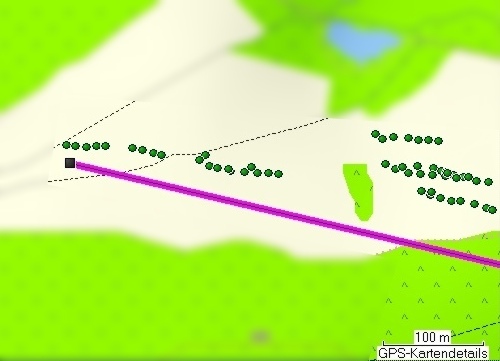 |
| Abb. 01: Die sechs Spuren, rechts: 1 (r.u.) , 2. (r.o.) 3 (l.u.) 4 (l.o.), links: 5 (r.) und 6 (l.) Etwas links der Bildmitte oben ist die Position des Solitärbaums bettelwiese Die lila Linie zeigt die Richtung zum Ziel in 3,6 km Entfernung an. Offensichtlich haben die Spuren eine parallele Ausrichtung zu dieser Linie und zeigen damit die Richtung zum Ziel! Six traces point to the target. The purple line is the direct line, distance 3,6 km. There was no visible contact possible between the two groups of traces. Obviously all traces have a parallel alignement to the direct line (violet) and point thereby the direction to the target. (FB) |
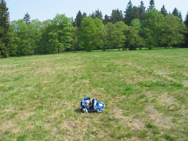 |
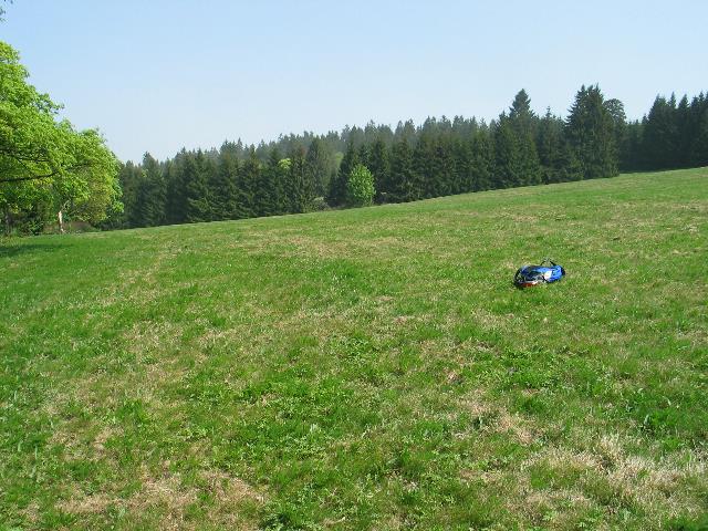
| Abb. 02: "Sendepunkt" Spur 1,
Original date/time: 2009:05:01 13:57:02 "sending" position 1 (FB) |
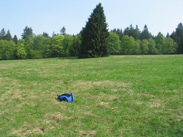 |
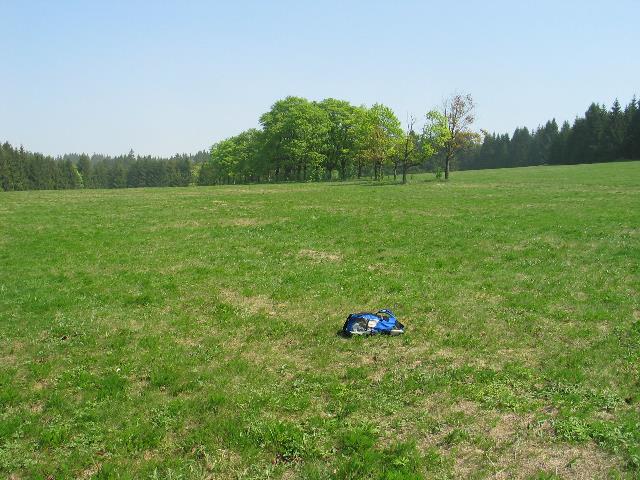
| Abb. 03: "Sendepunkt" Spur 4,
Original date/time: 2009:05:01 14:06:39 "sending" position 4 (FB) |
 |
| Abb. 04: "Sendepunkt" Spur 5,
Original date/time: 2009:05:01 14:22:05 "sending" position 5 (FB) |
 |
| Abb. 05: "Sendepunkt" Spur 6,
Original date/time: 2009:05:01 14:30:16 "sending" position 6 (FB) |
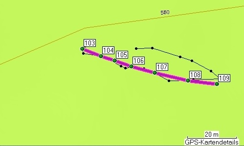 |
| Abb. 06: Spur 1: trace 1 (FB) |
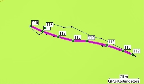 |
| Abb. 07: Spur 2: der Punkt 118
wurde beim Rückweg markiert. Trace 2, the point 118 was marked with going back to the starting point. (FB) |
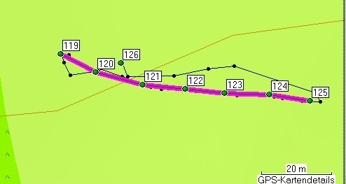 |
| Abb. 08: Spur 3: der Punkt 126
wurde beim Rückweg markiert Trace 3, the point 125 was marked with going back to the starting point. (FB) |
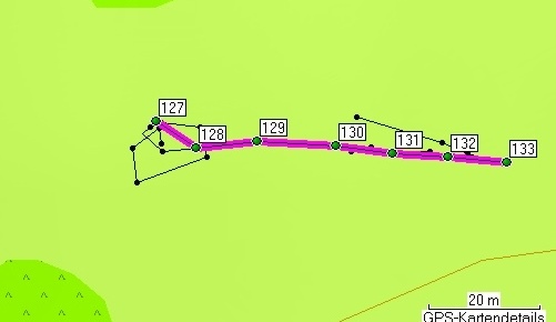 |
| Abb. 09: Spur 4: Der Start bei
Punkt 127 war problematisch, offensichtlich bewirkte dies eine
ortsfeste Störzone des Geländes Trace 4: To find the beginning of the trace was difficult, obviously caused by a disturbance located there. (FB) |
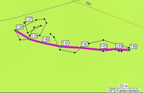 |
| Abb. 010: Spur 5: Auch bei Punkt
137 war die Spur überlagert und daher nicht zu finden. Daher erfolgte ein neuer Start bei Punkt 138 Trace 5: Also with point 137 the trace was covered by something else and could not be found. Therefore another "sending" point was used 138 (FB) |
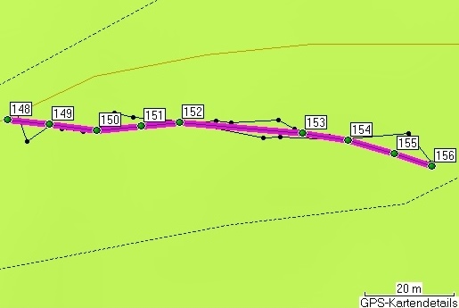 |
| Abb. 011: Spur 6: Trace 6 (FB) |
Gesamt Dauer 40 Minuten, Informationen zu den GPS-Daten: geologie-001 Elapsed time 40 minutes markierte Positionen der Spuren Name, Datum Uhrzeit, Koordinate Geländehöhe/Luftdruck Spur 1 103 01-MAI-09 13:50:35 N51 49 22.5 E10 17 56.5 594 m 104 01-MAI-09 13:51:01 N51 49 22.4 E10 17 56.9 591 m 105 01-MAI-09 13:51:09 N51 49 22.3 E10 17 57.2 591 m 106 01-MAI-09 13:51:17 N51 49 22.2 E10 17 57.6 592 m 107 01-MAI-09 13:51:26 N51 49 22.1 E10 17 58.0 592 m 108 01-MAI-09 13:51:38 N51 49 22.0 E10 17 58.8 592 m 109 01-MAI-09 13:51:48 N51 49 22.0 E10 17 59.4 593 m Spur 2 110 01-MAI-09 13:53:02 N51 49 21.7 E10 17 55.9 594 m 111 01-MAI-09 13:54:08 N51 49 21.6 E10 17 56.3 593 m 112 01-MAI-09 13:54:18 N51 49 21.5 E10 17 56.9 594 m 113 01-MAI-09 13:54:28 N51 49 21.4 E10 17 57.4 594 m 114 01-MAI-09 13:54:36 N51 49 21.4 E10 17 57.9 595 m 115 01-MAI-09 13:54:47 N51 49 21.3 E10 17 58.7 595 m 116 01-MAI-09 13:54:57 N51 49 21.2 E10 17 59.2 596 m 117 01-MAI-09 13:55:04 N51 49 21.1 E10 17 59.6 596 m 118 01-MAI-09 13:55:58 N51 49 21.7 E10 17 56.4 593 m Spur 3 119 01-MAI-09 13:58:04 N51 49 22.6 E10 17 54.0 589 m 120 01-MAI-09 13:59:29 N51 49 22.4 E10 17 54.5 590 m 121 01-MAI-09 13:59:41 N51 49 22.3 E10 17 55.2 590 m 122 01-MAI-09 13:59:52 N51 49 22.2 E10 17 55.8 591 m 123 01-MAI-09 14:00:02 N51 49 22.2 E10 17 56.4 591 m 124 01-MAI-09 14:00:12 N51 49 22.2 E10 17 57.1 592 m 125 01-MAI-09 14:00:22 N51 49 22.1 E10 17 57.7 592 m Spur 4 127 01-MAI-09 14:02:03 N51 49 23.5 E10 17 53.5 587 m 128 01-MAI-09 14:04:08 N51 49 23.4 E10 17 53.9 584 m 129 01-MAI-09 14:04:19 N51 49 23.4 E10 17 54.4 585 m 130 01-MAI-09 14:04:31 N51 49 23.4 E10 17 55.2 586 m 131 01-MAI-09 14:04:41 N51 49 23.4 E10 17 55.7 587 m 132 01-MAI-09 14:04:52 N51 49 23.3 E10 17 56.2 586 m 133 01-MAI-09 14:05:00 N51 49 23.3 E10 17 56.8 587 m 134 01-MAI-09 14:07:44 N51 49 22.5 E10 17 55.7 589 m 135 01-MAI-09 14:08:17 N51 49 22.3 E10 17 57.2 590 m 136 01-MAI-09 14:08:35 N51 49 22.1 E10 17 58.3 591 m Spur 5 137 01-MAI-09 14:14:51 N51 49 22.9 E10 17 44.6 590 m 138 01-MAI-09 14:17:46 N51 49 22.7 E10 17 44.2 588 m 139 01-MAI-09 14:19:05 N51 49 22.5 E10 17 44.8 591 m 140 01-MAI-09 14:19:16 N51 49 22.4 E10 17 45.2 589 m 141 01-MAI-09 14:19:29 N51 49 22.3 E10 17 45.9 591 m 142 01-MAI-09 14:19:39 N51 49 22.3 E10 17 46.6 590 m 143 01-MAI-09 14:19:51 N51 49 22.3 E10 17 47.3 589 m 144 01-MAI-09 14:20:01 N51 49 22.3 E10 17 47.9 588 m 145 01-MAI-09 14:20:09 N51 49 22.3 E10 17 48.4 590 m 146 01-MAI-09 14:20:44 N51 49 22.5 E10 17 47.0 588 m 147 01-MAI-09 14:21:15 N51 49 22.4 E10 17 45.8 590 m Spur 6 148 01-MAI-09 14:25:36 N51 49 23.2 E10 17 37.3 586 m 149 01-MAI-09 14:27:00 N51 49 23.2 E10 17 37.8 584 m 150 01-MAI-09 14:27:10 N51 49 23.1 E10 17 38.3 584 m 151 01-MAI-09 14:27:19 N51 49 23.1 E10 17 38.9 584 m 152 01-MAI-09 14:27:28 N51 49 23.2 E10 17 39.3 586 m 153 01-MAI-09 14:27:56 N51 49 23.1 E10 17 40.8 586 m 154 01-MAI-09 14:28:06 N51 49 23.0 E10 17 41.3 586 m 155 01-MAI-09 14:28:14 N51 49 22.9 E10 17 41.8 587 m 156 01-MAI-09 14:28:22 N51 49 22.9 E10 17 42.3 588 m |
 |
www.biosensor-physik.de | (c)
14.03.2010 F.Balck |
© BioSensor-Physik 2010 · Impressum