Beobachtungen
Observations:
Psi-Track-008, Verfolgen einer Spur, Orientierung,
Fortsetzung
Pursuing of a trace,
orientation, continuation
zum Verteiler Psi-Track und zu den anderen Psi-Track-Seiten psi-track-000
back
to
the main page of psi track
Von Uehrde bei Osterode nach Clausthal-Zellerfeld:
Entfernung Luftlinie 15 km. distance
Sendepunkte siehe Luftbild, http://maps.live.de/LiveSearch.LocalLive?
Interaktives Luftbild mit GoogleEarth aerial photography
uerde-clausthal.kmz
Zwischen Luftlinie und gefundener Spur gibt es prinzipiell Übereinstimmung.
In principle
agreement between found trace and direction line.
Alle Beobachtungen erfolgten nach der natürlichen Methode, d.h. ohne Hilfsmittel wie eine Rute.
Die Koordinaten der gefundenen Positionen wurden nachvollziehbar per GPS mit Datum und Uhrzeit protokolliert.
All
observations were done by the natural method, i.e. without aids like a
rod. The coordinates of the found positions and the walked tracks were
logged replicable by GPS with date and time.
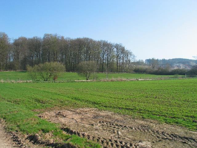 |
| Abb. 01: Blick
in Richtung der Spur, im Hintergrund der Steinbruch für die
Gipsherstellung. View toward the trace, in the background a stone quarry for gypsum production. (FB) |
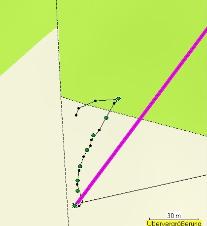 |
| Abb. 02: Die
gefundene Spur verläuft zunächst zu weit nach links, die
Richtung erreicht bei den letzten Punkten allerdings fast die der lila
Luftlinie. The found trace runs first too far to the left, the direction reached at the last points however nearly those of the purple direction line. (FB) |
| Tabelle der mit GPS protokollierten Punkte im Gelände geologie-001 Name Datum Zeit Koordinate Höhe nach Luftdruckmessung 356 10-APR-09 9:48:51 N51 42 15.1 E10 12 39.2 565 m Symbol 357 10-APR-09 9:49:07 N51 42 15.4 E10 12 39.3 565 m Symbol 358 10-APR-09 9:49:16 N51 42 15.6 E10 12 39.3 565 m Symbol 359 10-APR-09 9:49:26 N51 42 15.9 E10 12 39.4 564 m Symbol 360 10-APR-09 9:49:34 N51 42 16.2 E10 12 39.6 565 m Symbol 361 10-APR-09 9:49:44 N51 42 16.5 E10 12 39.8 565 m Symbol 362 10-APR-09 9:49:53 N51 42 16.8 E10 12 40.2 565 m Symbol 363 10-APR-09 9:50:08 N51 42 17.2 E10 12 40.6 566 m Symbol |
 |
www.biosensor-physik.de | (c)
14.03.2010 F.Balck |
© BioSensor-Physik 2010 · Impressum