Beobachtungen
Observations:
Psi-Track-011, Verfolgen einer Spur, Orientierung,
Fortsetzung
Pursuing of a trace,
orientation, continuation
zum Verteiler Psi-Track und zu den anderen Psi-Track-Seiten psi-track-000
back
to
the
main
page
of psi track
Ein persönlich bekanntes Ziel, ein Gebäude in größerer Entfernung, und ein nicht persönlich bekannter aber auf der Karte ausgewählter Ort wurden ausgewählt:
Das Capitol in Washington Entfernung 6574 km und die Stadt Hermannsburg Entfernung 114 km
A
personally
well
known
target at larger distance and a not personally
known but on a map inspected target were choosen.
Die gefundenen Spuren zeigen Abweichungen zur Luftlinie von weniger als 5 bzw. 20 Grad.
Bei der großen Entfernung nach Washington handelt es sich bei der vom Programm ausgerechneten Luftlinie um die kürzeste Verbindung auf der Kugeloberfläche. (Orthodrome)
(Denn, obwohl Washington auf einem südlicheren Breitengrad als der Startpunkt liegt, verläuft die Spur etwas nördlicher als die Richtung Westen.)
The found
traces have deviations to the direction line of less than 5 resp. 20
degrees.
With the large distance to Washington the direciton line calculated by the program is the shortest distance to the target along the earth's surface. (Orthodrome)
With the large distance to Washington the direciton line calculated by the program is the shortest distance to the target along the earth's surface. (Orthodrome)
Standort
http://maps.live.de/LiveSearch.LocalLive?
interaktives Luftbild mit GoogleEarth aerial photography
psi-track-012-washington.kmz
psi-track-012-hermannsburg.kmz
Alle Beobachtungen erfolgten nach der natürlichen Methode, d.h. ohne Hilfsmittel wie eine Rute.
Die Koordinaten der gefundenen Positionen wurden nachvollziehbar per GPS mit Datum und Uhrzeit protokolliert.
All
observations were done by the natural method, i.e. without aids like a
rod. The coordinates of the found positions and the walked tracks were
logged replicable by GPS with date and time.
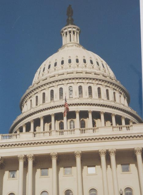 |
| Abb. 01: Capitol in Washington
(FB) |
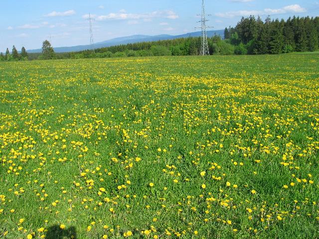 |
| Abb. 01a: Hier verläuft die
Spur in Richtung Washington, das Ziel liegt hinter dem Rücken des
Fotografen. Die Fußstapfen sind zu erahnen. On this meadow the trace in direction Washington was installed. The target is behind the back of the photographer. Some foot steps can be guessed in the grass. (FB) |
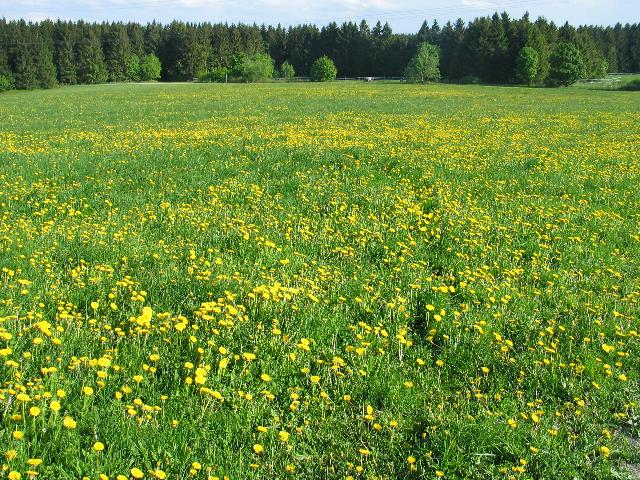 |
| Abb. 02: Die Spur in Richtung
Hermannsburg, das Ziel liegt hinter dem Rücken des Fotografen. Trace toward Hermannsburg, the target is behind the back of the photographer. (FB) |
 |
| Abb. 03: Etwa in dieser Richtung
liegt Hermannsburg. View toward Hermannsburg. (FB) |
 |
| Abb. 04: Beide Spuren wurden
innerhalb eines kurzen Zeitabstandes gelegt. Das Gelände ist nicht
frei von Störungen, hier verlaufen einige geologische
Störungen mit Quarz und Erzeinschlüssen etwa senkrecht zum
Weg am linken Bildrand. (siehe Abb. 07, Abb. 08 und Abb. 18
in erzgang-resonanz
) Both tracks were layed out within a short time. The area is not free of disturbances. There are some geological objects which are perceiveable under the earth's surface, vertically aligned to the way left picture edge. (FB) |
 |
| Abb. 05: Das Ziel Washington,
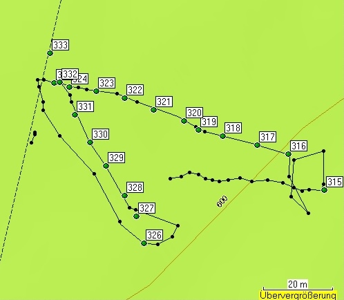
die gelegte Spur hat fast die Richtung der Luftlinie (lila). Der "Sendepunkt" hat die Bezeichnung 315. Beim Suchen des Spuranfangs wurde die Spur zunächst übersehen. Erst beim zweiten Rundgang um den "Sendepunkt" herum wurde die Spur gefunden. grün: markierte Punkte, schwarz: protokollierter Weg. The target Washington, the trace is almost parallel to the direction line (purple). At the "sending" point the trace first was missed. With a second trial it could be detected. green: marked points, black: track (FB) |
 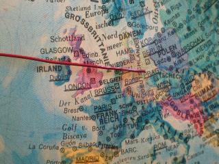 |
| Abb. 06: Obwohl Washington (38
Grad Nord) weiter südlich als Clausthal-Zellerfeld (52 Grad Nord)
liegt, verläuft die kürzeste Verbindung zwischen beiden Orten
(Luftlinie) von Deutschland aus gesehen etwas nördlich. Würde
man diese Richtung weiterverfolgen, käme man nach Umrundung der
Erde wieder am Startpunkt an. Diese Bahn beschreibt einen
"Großkreis" auf einer Ebene, die durch den Mittelpunkt der Erde
geht. In der Navigation gibt es die Begriffe Orthodrome (kürzeste Entfernung, auf Grosskreis) und Loxodrome Navigation (mit einem Kompaß, Bahn schneidet Meridiane in gleichem Winkel). Bei kurzen Entfernungen ist der Unterschied der Bahnen kaum zu bemerken, bei längeren Strecken ergeben sich jedoch deutliche Differenzen von Kurs und Wegstrecken. Direction line to Washington. The shortest way along the earth's surface is called Orthodrome. (purple line) (FB) |
 |
| Abb. 07: Das Ziel Hermannsburg,
die Abweichung der Spur zur Luftlinie beträgt etwa 20 Grad. grün: markierte Punkte, schwarz: protokollierter Weg. The target Hermannsburg, deviation about 20 degrees. green: marked points, black: track (FB) |
|
Liste der markierten Punkte, Aufteilung nach einzelnen Abschnitten Capitol in Washington Gesamt Dauer 4 Minuten, Informationen zu den GPS-Daten: geologie-001 elapsed time 4 minutes markierte Positionen der Spuren Name, Datum Uhrzeit, Koordinate Geländehöhe/Luftdruck 315 13-MAI-09 17:28:10 N51 49 16.5 E10 21 36.3 596 m 316 13-MAI-09 17:30:08 N51 49 16.8 E10 21 35.7 599 m 317 13-MAI-09 17:30:21 N51 49 16.9 E10 21 35.3 598 m 318 13-MAI-09 17:30:32 N51 49 17.0 E10 21 34.7 599 m 319 13-MAI-09 17:30:40 N51 49 17.1 E10 21 34.4 600 m 320 13-MAI-09 17:30:49 N51 49 17.2 E10 21 34.1 598 m 321 13-MAI-09 17:30:59 N51 49 17.3 E10 21 33.7 600 m 322 13-MAI-09 17:31:09 N51 49 17.4 E10 21 33.2 600 m 323 13-MAI-09 17:31:18 N51 49 17.4 E10 21 32.8 600 m 324 13-MAI-09 17:31:26 N51 49 17.5 E10 21 32.4 599 m 325 13-MAI-09 17:31:32 N51 49 17.5 E10 21 32.2 599 m Washington, Capitol N38 53 24.5 W77 00 36.0 Route 315 bis Washington, Capitol 6574 km 295° Protokoll der abgelaufenen Wege (Track) 1 13.05.2009 17:27:08 523 m 3 m 0:00:02 6 km/h 77° N51 49 16.6 E10 21 33.9 2 13.05.2009 17:27:10 528 m 3 m 0:00:02 5 km/h 66° N51 49 16.6 E10 21 34.1 3 13.05.2009 17:27:12 533 m 3 m 0:00:02 5 km/h 100° N51 49 16.7 E10 21 34.2 4 13.05.2009 17:27:14 538 m 2 m 0:00:02 4 km/h 123° N51 49 16.7 E10 21 34.3 5 13.05.2009 17:27:16 542 m 2 m 0:00:02 4 km/h 100° N51 49 16.6 E10 21 34.4 6 13.05.2009 17:27:18 546 m 2 m 0:00:02 4 km/h 99° N51 49 16.6 E10 21 34.6 7 13.05.2009 17:27:20 549 m 3 m 0:00:02 5 km/h 81° N51 49 16.6 E10 21 34.7 8 13.05.2009 17:27:22 553 m 3 m 0:00:03 4 km/h 80° N51 49 16.6 E10 21 34.8 9 13.05.2009 17:27:25 558 m 4 m 0:00:03 4 km/h 107° N51 49 16.6 E10 21 35.0 10 13.05.2009 17:27:28 562 m 5 m 0:00:03 5 km/h 84° N51 49 16.6 E10 21 35.2 11 13.05.2009 17:27:31 565 m 5 m 0:00:03 5 km/h 101° N51 49 16.6 E10 21 35.4 12 13.05.2009 17:27:34 570 m 3 m 0:00:03 4 km/h 114° N51 49 16.6 E10 21 35.6 13 13.05.2009 17:27:37 573 m 3 m 0:00:03 3 km/h 115° N51 49 16.5 E10 21 35.8 14 13.05.2009 17:27:40 576 m 0 m 0:00:04 0.2 km/h 25° N51 49 16.5 E10 21 35.9 15 13.05.2009 17:27:44 580 m 0 m 0:00:03 0.2 km/h 232° N51 49 16.5 E10 21 35.9 16 13.05.2009 17:27:47 583 m 0 m 0:00:03 0.3 km/h 255° N51 49 16.5 E10 21 35.9 17 13.05.2009 17:27:50 586 m 0 m 0:00:06 0.2 km/h 348° N51 49 16.5 E10 21 35.9 18 13.05.2009 17:27:56 589 m 1 m 0:00:04 1.0 km/h 90° N51 49 16.5 E10 21 35.9 19 13.05.2009 17:28:00 592 m 1 m 0:00:01 5 km/h 87° N51 49 16.5 E10 21 36.0 20 13.05.2009 17:28:01 592 m 4 m 0:00:08 2 km/h 93° N51 49 16.5 E10 21 36.0 21 13.05.2009 17:28:09 595 m 1 m 0:00:17 0.2 km/h 327° N51 49 16.5 E10 21 36.2 22 13.05.2009 17:28:26 599 m 1 m 0:00:22 0.2 km/h 27° N51 49 16.5 E10 21 36.2 23 13.05.2009 17:28:48 600 m 10 m 0:00:07 5 km/h 0° N51 49 16.6 E10 21 36.2 24 13.05.2009 17:28:55 600 m 9 m 0:00:15 2 km/h 254° N51 49 16.9 E10 21 36.2 25 13.05.2009 17:29:10 599 m 11 m 0:00:14 3 km/h 184° N51 49 16.8 E10 21 35.8 26 13.05.2009 17:29:24 599 m 7 m 0:00:15 2 km/h 134° N51 49 16.5 E10 21 35.7 27 13.05.2009 17:29:39 600 m 12 m 0:00:16 3 km/h 332° N51 49 16.3 E10 21 36.0 28 13.05.2009 17:29:55 600 m 6 m 0:00:13 2 km/h 1° N51 49 16.6 E10 21 35.7 29 13.05.2009 17:30:08 599 m 0 m 0:00:03 0.5 km/h 286° N51 49 16.8 E10 21 35.7 30 13.05.2009 17:30:11 601 m 10 m 0:00:11 3 km/h 287° N51 49 16.9 E10 21 35.7 31 13.05.2009 17:30:22 598 m 1 m 0:00:02 2 km/h 294° N51 49 16.9 E10 21 35.2 32 13.05.2009 17:30:24 600 m 14 m 0:00:15 3 km/h 283° N51 49 17.0 E10 21 35.2 33 13.05.2009 17:30:39 600 m 3 m 0:00:04 3 km/h 298° N51 49 17.1 E10 21 34.4 34 13.05.2009 17:30:43 600 m 4 m 0:00:06 2 km/h 301° N51 49 17.1 E10 21 34.3 35 13.05.2009 17:30:49 598 m 2 m 0:00:02 3 km/h 299° N51 49 17.2 E10 21 34.1 36 13.05.2009 17:30:51 600 m 13 m 0:00:14 3 km/h 289° N51 49 17.2 E10 21 34.0 37 13.05.2009 17:31:05 601 m 6 m 0:00:07 3 km/h 294° N51 49 17.3 E10 21 33.4 38 13.05.2009 17:31:12 602 m 9 m 0:00:09 4 km/h 277° N51 49 17.4 E10 21 33.1 39 13.05.2009 17:31:21 602 m 2 m 0:00:03 3 km/h 284° N51 49 17.5 E10 21 32.7 40 13.05.2009 17:31:24 602 m 3 m 0:00:03 3 km/h 277° N51 49 17.5 E10 21 32.5 41 13.05.2009 17:31:27 599 m 1 m 0:00:01 4 km/h 298° N51 49 17.5 E10 21 32.4 42 13.05.2009 17:31:28 602 m 3 m 0:00:04 3 km/h 278° N51 49 17.5 E10 21 32.3 43 13.05.2009 17:31:32 599 m 2 m 0:00:02 3 km/h 288° N51 49 17.5 E10 21 32.2 44 13.05.2009 17:31:34 602 m 1 m 0:00:01 5 km/h 283° N51 49 17.5 E10 21 32.1 45 13.05.2009 17:31:35 602 m 5 m 0:03:03 0.1 km/h 100° N51 49 17.5 E10 21 32.0 Hermannsburg Gesamt Dauer 2 Minuten, markierte Positionen der Spuren Name, Datum Uhrzeit, Koordinate Geländehöhe/Luftdruck 326 13-MAI-09
17:32:47 N51 49 16.0
E10 21 33.5 600 m
327 13-MAI-09 17:33:50 N51 49 16.3 E10 21 33.4 599 m 328 13-MAI-09 17:33:59 N51 49 16.5 E10 21 33.2 600 m 329 13-MAI-09 17:34:09 N51 49 16.7 E10 21 33.0 600 m 330 13-MAI-09 17:34:17 N51 49 17.0 E10 21 32.7 601 m 331 13-MAI-09 17:34:28 N51 49 17.2 E10 21 32.5 601 m 332 13-MAI-09 17:34:38 N51 49 17.5 E10 21 32.3 601 m 333 13-MAI-09 17:34:47 N51 49 17.8 E10 21 32.1 602 m Hermannsburg N52 49 56.2 E10 05 21.2 51 m Route 326 bis Hermannsburg 114 km 351° |
| Tabellen mit den GPS-Daten (FB) |
 |
www.biosensor-physik.de | (c)
01.07.2010 F.Balck |
© BioSensor-Physik 2010 · Impressum