Beobachtungen
Observations:
Psi-Track-017, Verfolgen einer Spur, Orientierung,
Fortsetzung
Pursuing of a trace,
orientation, continuation
zum Verteiler Psi-Track und zu den anderen Psi-Track-Seiten psi-track-000
back
to
the main page of psi track
Fünf persönlich bekannte Ziele, Gebäude in größerer Entfernung:
five
targets
well known by the author, buildings in larger distances
Boltenhagen an der Ostsee Entfernung 248 km , distance 248 km
Maspalomas auf Gran Canaria Entfernung 3439 km
Cala Rajada auf Mallorca Entfernung 1448 km
und eine Person auf der Durchreise, vermutlich Berliner Ring, Entfernung 208 km a person on the transit, probably Berlin ring
Bei allen drei Zielen war der Winkelfehler der gefundenen Spuren weniger als 10 Grad.
Beim ersten Ziel wurde später offensichtlich eine Störung verfolgt, der Winkelfehler nahm ab dem fünften Punkt zu.
With all
three targets the angle error of the found traces was less than 10
degrees.
With the first object obviously a disturbance was pursued, the angle error increased starting from the fifth point.
With the first object obviously a disturbance was pursued, the angle error increased starting from the fifth point.
Einen Tag später wurden von Standort 3 zwei weitere Ziele angepeilt.
One
day
later two further objects were searched from starting position
3.
Budapest Entfernung 791 kmScarborough Entfernung 771 km
Hier liegen die Winkelabweichung im Bereich bis 30 Grad. Angle error was about 30 degrees.
Bei der Peilung zu einer Person in Richtung Berlin wurden mehrere parallele Zonen beobachtet. Abb. 03, Punkte 011 bis 017
During the
bearing to a person toward Berlin several parallel zones were observed.
Die Standorte 2 und 3 liegt im Winkel einer Hochspannungsleitung und auch im Bereich von Quarz- bzw. Erzgängen.
erzgang-resonanz.htm Abb. 14
The locations
2 and 3 lies in the range of a high voltage transmission line and also
within the range of quartz and ore veins.
Standort 1 Bockswieser Höhe
http://maps.live.de/LiveSearch.LocalLive?
interaktives Luftbild mit GoogleEarth aerial photograph
psi-016-boltenhagen.kmz
Standort 2 Am Sonnenhof
http://maps.live.de/LiveSearch.LocalLive?
interaktives Luftbild mit GoogleEarth
psi-017-canaria.kmz
Standort 3 Am Sonnenhof
er liegt unmittelbar in der Nähe von Standort 2, einen Tag später in the prioximity of lacation 2, one day later
interaktives Luftbild mit GoogleEarth
psi-018-budapest.kmz
Alle Beobachtungen erfolgten nach der natürlichen Methode, d.h. ohne Hilfsmittel wie eine Rute.
Die Koordinaten der gefundenen Positionen wurden nachvollziehbar per GPS mit Datum und Uhrzeit protokolliert.
All
observations were done by the natural method, i.e. without aids like a
rod. The coordinates of the found positions and the walked tracks were
logged replicable by GPS with date and time.
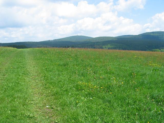 |
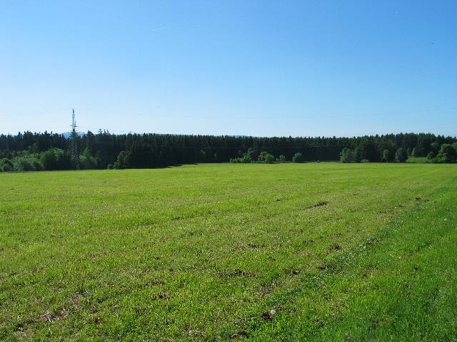
| Abb. 01: Standort 1, Wiese bei
der Bockswieser Höhe, "Sendepunkt" und Blick in Richtung
Boltenhagen Original date/time: 2009:05:23 11:24:42 Starting location 1, meadow Bockswieser Hoehe, "sending" position and view toward Boltenhagen (FB) |
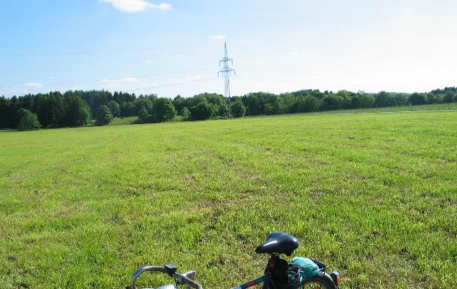 |
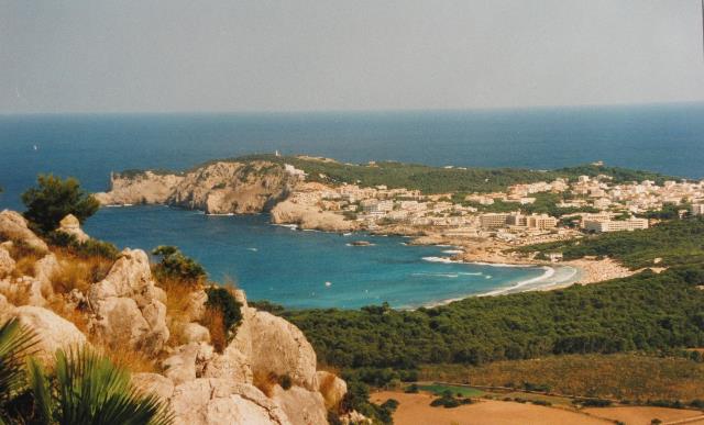
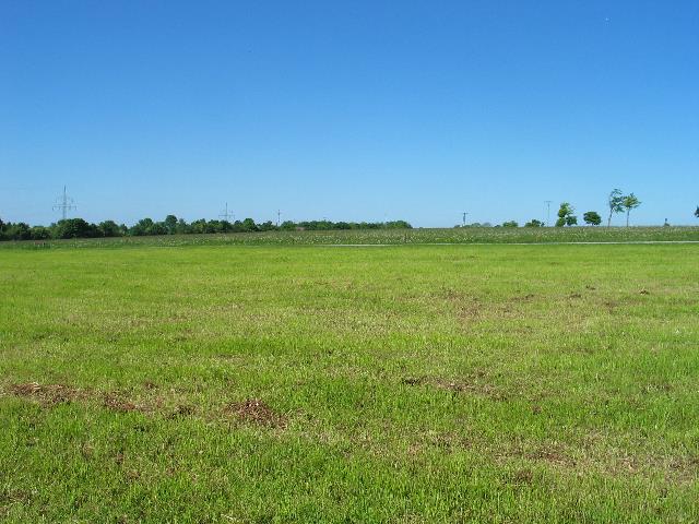
| Abb. 02: Standort 2, Wiese am
Sonnenhof, Blick in Richtung Gran Canaria (rechts) und Mallorca (links) Original date/time: 2009:05:23 16:30:28 Location 2, meadow at Sonnenhof, view toward Gran Cananria (right) and Mallorca (left) (FB) |
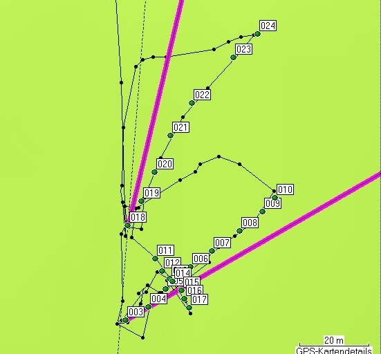 |
| Abb. 03: Standort 1: Punkte 018 bis 025, Spur und Luftlinie (oben, lila) in Richtung Boltenhagen, Abweichung 10 Grad. Ab Punkt 022 gibt es offensichtlich eine Richtungsänderung bedingt durch eine Störung? Punkte 003 bis 010, das Ziel ist eine bekannte Person auf der Durchreise von Leipzig bis Boltenhagen, vermutlich in der Nähe von Berlin, Luftlinie nach Berlin (lila). Beim anschließenden Queren der Spur waren die Punkte 011 bis 017 als parallele Spuren zu bemerken. Location 1 Points 018 to 025: trace (black) and direction line (upper, purple) toward Boltenhagen. Deviation 10 degrees. The changing of the direction at point 022 is possibly due to a disturbance? Points 003 to 010: the target is a known person on the transit from Leipzig to Boltenhagen, probably at this time in the near of Berlin, direction line to Berlin (lower, purple). Crossing this trace subsequently revealed some other parallel traces. (FB) |
 |
| Abb. 04a: Mallorca, Cala Rajada
(FB) |
 |
| Abb. 04b: Gran Canaria,
Maspalomas (FB) |
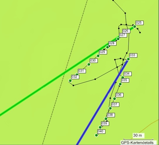 |
| Abb. 04c: Standort 2, Auf der
Wiese
am Sonnenhof. Die Spur 025 bis 032 zeigt nach Gran Canaria, Abweichung etwa 8 Grad (grün) Die Spur 033 bis 040 zeigt nach Mallorca, Abweichung etwa 8 Grad. (blau) Zu Beginn einer jeden Spur ist jeweils der Suchbogen mit schwarzen Punkten protokolliert. Location 2, On a meadow at Sonnenhof Trace 025 to 032 points toward Grancania, deviation about 8 degress (green). Trace 033 to 040 points toward Mallorca, deviation about 8 degrees (blue) The beginning of each search starts with a path on semicircle around the starting position. (black lines) (FB) |
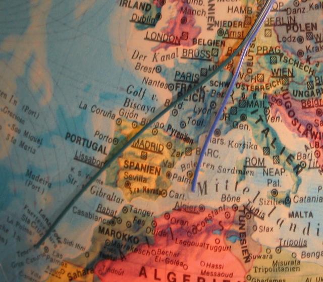 |
| Abb. 04a: Die Verbindungen vom
Harz in Richtung Gran Canaria (grün) und Mallorca (blau) wurden
mit Kabel auf einem Globus markiert. Direction lines between the Harz Mountains toward Gran Canaria (green) and Mallorca (blue). (FB) |
|
Liste
der
markierten Punkte, Aufteilung nach einzelnen Abschnitten
Gesamt Dauer jeweils etwa zwei Minuten, Informationen zu den GPS-Daten: geologie-001 Duration: about two minutes each markierte Positionen der Spuren Name, Datum Uhrzeit, Koordinate Geländehöhe/Luftdruck Standort 1: Richtung Boltenhagen 018 23-MAI-09 11:31:53 N51 49 32.1 E10 20 17.5 596 m 019 23-MAI-09 11:32:39 N51 49 32.3 E10 20 17.7 596 m 020 23-MAI-09 11:32:51 N51 49 32.6 E10 20 17.9 596 m 021 23-MAI-09 11:33:03 N51 49 32.9 E10 20 18.2 595 m 022 23-MAI-09 11:33:14 N51 49 33.2 E10 20 18.5 595 m 023 23-MAI-09 11:33:32 N51 49 33.7 E10 20 19.1 594 m 024 23-MAI-09 11:33:43 N51 49 33.9 E10 20 19.5 593 m Boltenhagen N53 59 20.4 E11 12 20.2 0 m Route
018 bis Boltenhagen 248 km 13° Standort 1: Richtung Berliner Ring, eine Person auf der Durchreise 003 23-MAI-09 11:25:07 N51 49 31.2 E10 20 17.5 592 m 004 23-MAI-09 11:26:18 N51 49 31.3 E10 20 17.8 592 m 005 23-MAI-09 11:26:28 N51 49 31.5 E10 20 18.1 593 m 006 23-MAI-09 11:26:39 N51 49 31.7 E10 20 18.5 593 m 007 23-MAI-09 11:26:48 N51 49 31.8 E10 20 18.8 592 m 008 23-MAI-09 11:26:59 N51 49 32.0 E10 20 19.2 592 m 009 23-MAI-09 11:27:08 N51 49 32.2 E10 20 19.5 593 m 010 23-MAI-09 11:27:13 N51 49 32.3 E10 20 19.7 592 m 011 23-MAI-09 11:28:37 N51 49 31.8 E10 20 17.9 595 m 012 23-MAI-09 11:28:45 N51 49 31.7 E10 20 18.0 595 m 013 23-MAI-09 11:28:53 N51 49 31.6 E10 20 18.1 594 m 014 23-MAI-09 11:28:58 N51 49 31.6 E10 20 18.2 594 m 015 23-MAI-09 11:29:06 N51 49 31.5 E10 20 18.3 593 m 016 23-MAI-09 11:29:12 N51 49 31.4 E10 20 18.4 593 m 017 23-MAI-09 11:29:18 N51 49 31.3 E10 20 18.4 594 m Berliner Ring, A24undA10 A24 und A10 N52 44 03.7 E13 00 28.1 Route 003 bis Berliner Ring, A24undA10 208 km 60° Wahr 2 Standort 2: Richtung Maspalomas, Gran Canaria 025 23-MAI-09 16:31:19 N51 49 20.3 E10 21 35.3 564 m 026 23-MAI-09 16:31:59 N51 49 20.1 E10 21 34.7 565 m 027 23-MAI-09 16:32:08 N51 49 19.9 E10 21 34.6 565 m 028 23-MAI-09 16:32:17 N51 49 19.6 E10 21 34.2 566 m 029 23-MAI-09 16:32:26 N51 49 19.4 E10 21 33.8 566 m 030 23-MAI-09 16:32:36 N51 49 19.1 E10 21 33.4 565 m 031 23-MAI-09 16:32:46 N51 49 18.7 E10 21 32.9 566 m 032 23-MAI-09 16:32:54 N51 49 18.5 E10 21 32.7 565 m Maspalomas N27 44 34.5 W15 34 57.7 Route 025 bis Maspalomas 3439 km 229° Standort 2: Richtung Cala Rajada, Mallorca 033 23-MAI-09 16:33:45 N51 49 19.2 E10 21 35.0 569 m 034 23-MAI-09 16:34:45 N51 49 18.6 E10 21 34.8 567 m 035 23-MAI-09 16:34:56 N51 49 18.4 E10 21 34.7 566 m 036 23-MAI-09 16:35:08 N51 49 17.9 E10 21 34.5 566 m 037 23-MAI-09 16:35:17 N51 49 17.6 E10 21 34.3 566 m 038 23-MAI-09 16:35:25 N51 49 17.3 E10 21 34.1 567 m 039 23-MAI-09 16:35:34 N51 49 17.0 E10 21 33.9 567 m 040 23-MAI-09 16:35:41 N51 49 16.7 E10 21 33.7 567 m Mallorca N39 42 34.6 E3 27 48.4 Route 033 bis Mallorca 1448 km 204° |
Von Standort 3 nach Scarborough und Budapest
Einen Tag später, fast an der gleichen Stelle. One day later, almost at the same position
 |
| Abb. 05: Standort 3, Richtung
Budapest location
3, direction toward Budapest Original date/time: 2009:05:24 10:15:58 (FB) |
 |
| Abb. 06: Standort 3, Richtung
Scarborough location
3,
direction toward Scarborough Original date/time: 2009:05:24 10:16:43 (FB) |
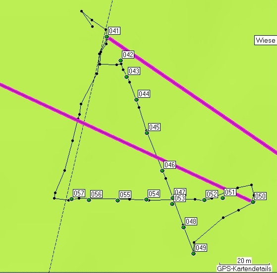 |
| Abb. 07: Die markierten Punkte
in Richtung Scarborough 050 bis 057, und in Richtung Budapest 041 bis
049. Am Anfang jeder Suchstrecke zeigen die schwarzen Linien und Punkte
den Suchkreis an. Die lila Linien sind die Richtung der Luftlinien. Es gibt größere Abweichungen: -25 Grad für Scarborough und +30 Grad für Budapest. Marked positions of the found traces toward Scarborough 050 to 057 and Budapest 041 to 049. Each trace starts with a semicircle (black lines). The direction lines are purple colored. There are larger deviations -25 degree (Scarborough) and + 30 degree (Budapest) (FB) |
| Liste
der
markierten Punkte, Aufteilung nach einzelnen Abschnitten Scarborough und Budapest Gesamt Dauer jeweils 2 Minuten, Informationen zu den GPS-Daten: geologie-001 duration about 2 minutes each markierte Positionen der Spuren Name, Datum Uhrzeit, Koordinate Geländehöhe/Luftdruck 041 24-MAI-09 10:09:20 N51 49 22.7 E10 21 34.0 566 m 042 24-MAI-09 10:10:00 N51 49 22.4 E10 21 34.3 568 m 043 24-MAI-09 10:10:07 N51 49 22.2 E10 21 34.4 567 m 044 24-MAI-09 10:10:16 N51 49 21.9 E10 21 34.6 565 m 045 24-MAI-09 10:10:27 N51 49 21.5 E10 21 34.9 568 m 046 24-MAI-09 10:10:39 N51 49 21.0 E10 21 35.2 567 m 047 24-MAI-09 10:10:48 N51 49 20.6 E10 21 35.4 567 m 048 24-MAI-09 10:10:58 N51 49 20.2 E10 21 35.6 565 m 049 24-MAI-09 10:11:07 N51 49 19.9 E10 21 35.8 567 m 050 24-MAI-09 10:11:39 N51 49 20.6 E10 21 37.1 564 m 051 24-MAI-09 10:12:22 N51 49 20.6 E10 21 36.5 569 m 052 24-MAI-09 10:12:29 N51 49 20.6 E10 21 36.1 569 m 053 24-MAI-09 10:12:40 N51 49 20.5 E10 21 35.4 568 m 054 24-MAI-09 10:12:49 N51 49 20.6 E10 21 34.8 570 m 055 24-MAI-09 10:12:58 N51 49 20.6 E10 21 34.2 570 m 056 24-MAI-09 10:13:07 N51 49 20.6 E10 21 33.6 571 m 057 24-MAI-09 10:13:14 N51 49 20.6 E10 21 33.3 571 m Budapest N47 28 50.1 E19 03 09.6 Scarborough N54 16 50.5 W0 24 43.2 Route 041 bis Budapest 791 km 124° 050 bis Scarborough 771 km 295° |
 |
www.biosensor-physik.de | (c)
01.07.2010 F.Balck |
© BioSensor-Physik 2010 · Impressum