Beobachtungen:
Rohrbruch, Pipe burst
Immer wenn sich Materie bewegt, bilden sich feinstoffliche Strukturen.
Dies ist im Zweidimensionalen vergleichbar mit einem fahrenden Schiff auf einer glatten Wasserfläche: selbst auf einem Luftbild aus großer Höhe sind dessen Spuren zu entdecken, obwohl das Schiff nur als kleiner Fleck erscheint.
Wenn sensitive Personen bei einem Wasserrohrbruch die zugehörigen feinstofflichen Strukturen finden, bedeutet es noch lange nicht, daß sie den Ort des Schadens auf wenige Meter angeben können.
Würde sich das ausfließende Wasser wie die Fontäne bei einem Springbrunnen als senkrechter Strahl verhalten, gäbe es klare Bedingungen für die Ortung. Meist ist der austretende Strahl aber nicht so ideal geformt und verteilt sich nicht gleichmäßig z.B. in einem wasserdurchlässigen Sandbett. Es gibt viele Möglichkeiten für das abfließende Wasser, wenn der Untergrund nur eingeschränkt durchlässig ist. Dann wird sich das Wasser eigene Wege suchen - und diese erzeugen dann wieder feinstoffliche Strukturen, die sich mit den anderen überlagern.
Ein guter detektierbarer Bruch verhält sich wie eine unterirdische Quelle, wo das Wasser nicht bis zur Erdoberfläche nach oben kommt. (Blind-Spring)
Die für sensitive Personen spürbare Wirkung von bewegtem Wasser wird sehr viel intensiver wahrnehmbar, wenn elektromagnetische Wechselfelder in der Nähe sind. Daher kann es sein, daß fließendes Wasser alleine einen schwächeren Eindruck hinterläßt, als solches, das weniger stark fließt aber durch solche Wechselfelder angeregt wird.
Dies ist zu berücksichtigen bei der Suche nach einem Rohrbruch in der Nähe von Stromkabeln.
Whenever matter moves, subtle structures form.
This is comparable in two dimensions to a moving ship on a smooth surface of water: even on an aerial photograph taken from a great height, its traces can be detected, although the ship only appears as a small spot.
If sensitive persons find the corresponding subtle structures when a water pipe bursts, it does not mean that they can indicate the location of the damage within a few metres.
If the outflowing water behaved as a vertical jet like the fountain in a fountain, there would be clear conditions for locating it. In most cases, however, the outflowing jet is not so ideally shaped and does not distribute itself evenly, e.g. in a water-permeable sand bed. There are many possibilities for the water to run off if the subsoil is only permeable to a limited extent. Then the water will look for its own paths - and these will again create subtle structures that overlap with the others.
A good detectable fracture behaves like an underground spring where the water does not come up to the earth's surface.
(Blind Spring)
The effect of moving water, which is perceptible to sensitive persons, becomes much more intensely perceptible when alternating electromagnetic fields are in the vicinity. Therefore, flowing water alone may leave a weaker impression than water that flows less strongly but is excited by such alternating fields.
This should be taken into account when searching for a burst pipe near power cables.
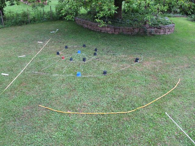
Am 29.11.2016 war ein Rohrbruch zu orten.
Mithilfe üblicher Technik (Geräusche ..) hatte der Rohrnetzmeister Rainer Cornehl aus Hardegsen* den Ort des Schadens eingegrenzt.
Anschließend wurde der Autor hinzugerufen. Er ging über das Gelände und konnte durch Spüren eine Position etwa 1 m westlich von der angegebenen Stelle sowie eine weitere (schwächere) in etwa 20 m nach Westen benennen. An der ersten Stelle war die spürbare Intensität besonders hoch, an der zweiten etwas schwächer.
Am 30.11.2016 hatte man gegen 9 Uhr schon mit den Erdarbeiten angefangen.
Der Autor ging das Gelände ab und versuchte nun, die Geometrie der spürbaren Strukturen aufzunehmen.
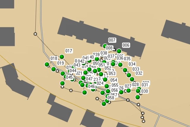
Es waren große radiale Streifen und konzentrische Ringe. Er markierte die GPS-Koordinaten einzelner Elemente. (Abb. 15)
Für die Datenaufnahme waren weniger als eine Viertelstunde nötig.
Wie sich aus den Daten ergibt, liegt der Schadensort genau im Mittelpunkt eines gefundenen Halbkreises und ist Schnittpunkt von einigen radialen Strahlen.
Der Radius dieses Kreises beträgt 36 m. Es gibt viele weitere dazu konzentrische Kreise etwa im Abstand von 3 m
Am 01.12.2016 wurde nach Reparatur des Schadens die etwa 20 m entfernte zweite Struktur aufgenommen.
Auch hier gibt es radiale und konzentrische Elemente.
On 29.11.2016, a burst pipe was located.
With the help of the usual technology (noises ...), the pipe network foreman R. C. from Hardegsen* had narrowed down the location of the damage.
The author was then called in. He walked over the area and was able to perceive a position about 1 m west of the indicated location as well as another (weaker) one about 20 m to the west. At the first location the perceptible intensity was particularly high, at the second somewhat weaker.
On 30.11.2016, earthworks had already started at about 9 am.
The author walked the terrain and now tried to record the geometry of the perceptible structures.
They were large radial stripes and concentric rings. He marked the GPS coordinates of individual elements. (Fig. 15)
It took less than a quarter of an hour to record the data.
As can be seen from the data, the damage site is exactly in the centre of a semicircle found and is the intersection of some radial rays.
The radius of this circle is 36 m. There are many more concentric circles about 3 m apart.
On 01.12.2016, after repairing the damage, the second structure about 20 m away was recorded.
Here, too, there are radial and concentric elements.
* magnetfeld-anregung.htm#kapitel-03
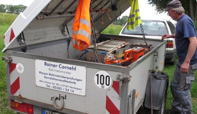 |
Abb. 00: Der Rohrnetzmeister und seine Geräte aus magnetfeld-anregung.htm#kapitel-03 |
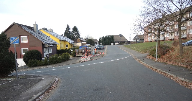 |
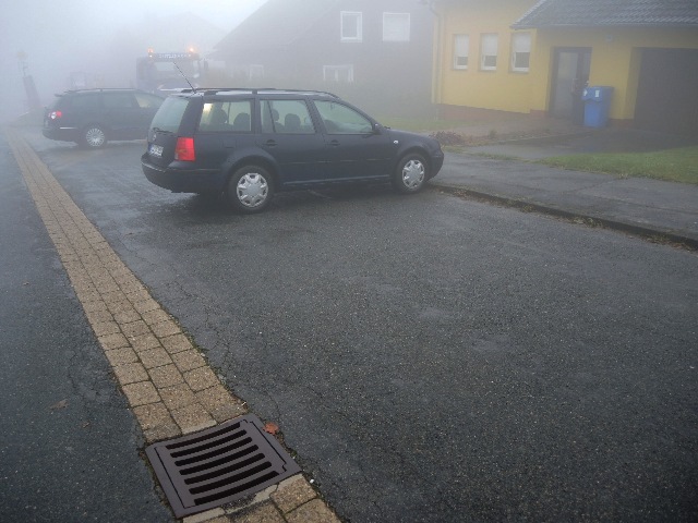
| Abb. 01: Berlinerstraße / Am Sonnenhang, 38678 Clausthal-Zellerfeld rechts das Gebäude Berliner Strasse 105-109, Länge 52 m. 30.11.2016 9:28 (FB) |
 |
| Abb. 02: Die schwächer spürbare Stelle befindet sich direkt hinter dem dunklen Auto. The less perceptible spot is directly behind the dark car. (FB) |
 |
| Abb. 03: von FB gemutete Stelle, location mapped by FB, 09:53 (FB) |
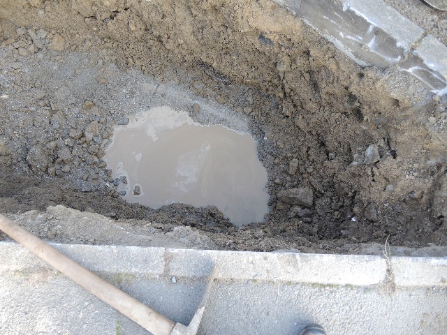 |
| Abb. 04: Treffer, Wasser gefunden Hit, water found (FB) |
 |
| Abb.
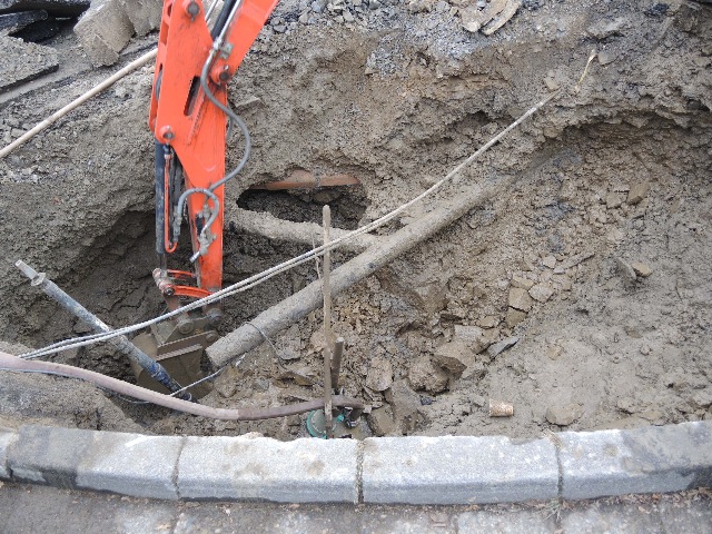
05: 13:41 Pumpe, Gasleitung wird sichtbar. Die
Schadensstelle liegt noch sehr viel tiefer, rechts von der Pumpe. Pump, gas pipe becomes visible. The damage site is still much deeper, to the right of the pump.(FB) |
 |
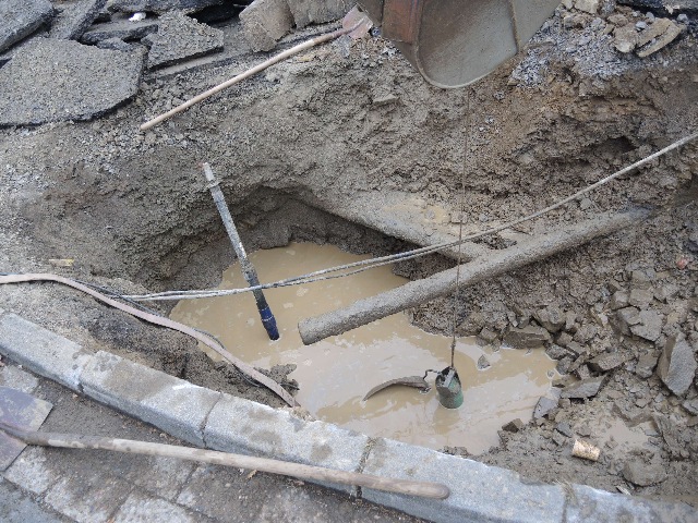
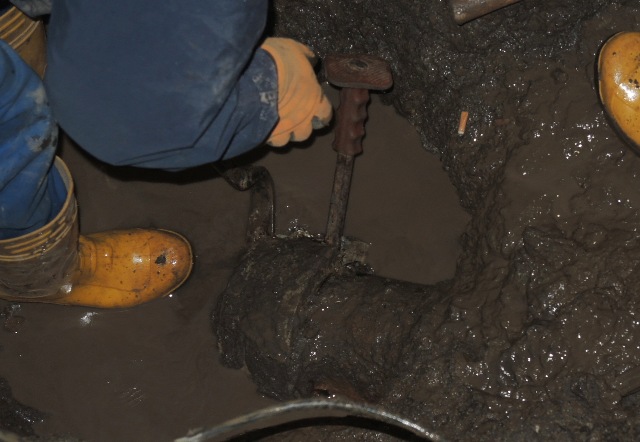
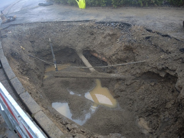
| Abb. 06: Baggern in über zwei Meter Tiefe. Schadensstelle ist in Verlängerung der Fuge der beiden rechten Bordsteine. Excavation at a depth of more than two metres. The point of damage is in the extension of the joint of the two right-hand kerbs. (FB) |
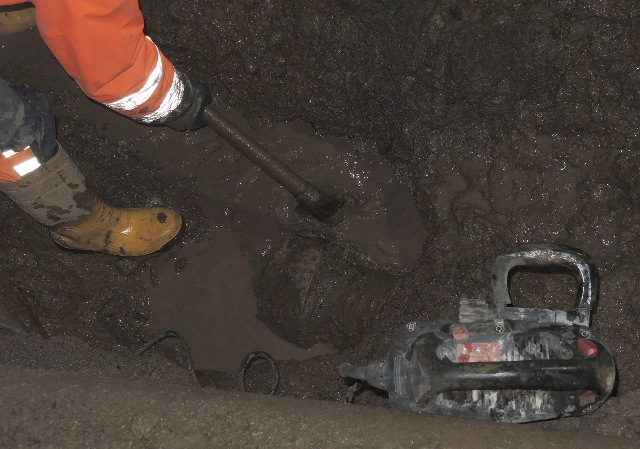 |
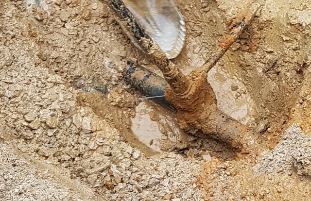
| Abb. 07: Eine Steckmuffe wird sichtbar. A plug-in sleeve becomes visible. 16:12 (FB) |
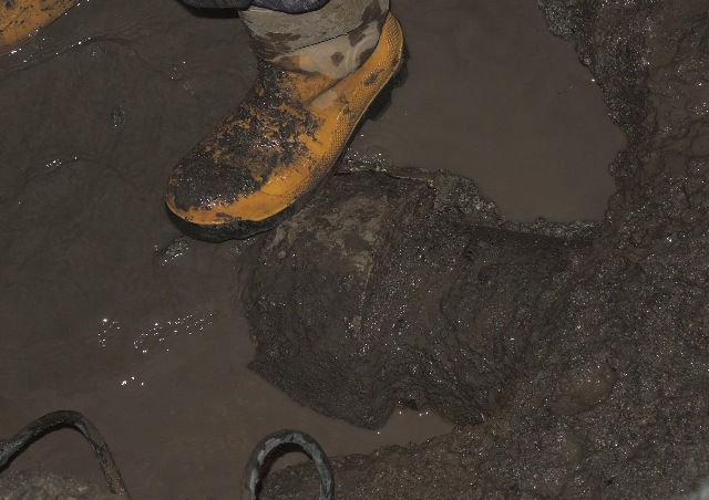 |
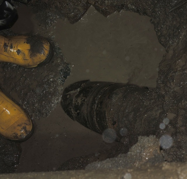
| Abb. 08: Die Steckmuffe ist gerissen (oben, kurz über der Wasseroberfläche) The sleeve is cracked (at the top, just above the water surface). (FB) |
 |
| Abb. 09: Sie wird aufgestemmt. It is being prised open. (FB) |
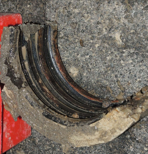 |
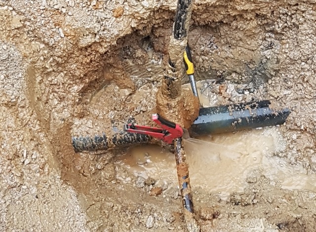
| Abb. 10: Steckmuffe aus Eternit mit drei Gummiringen. Eternit sleeve with three rubber rings.(FB) |
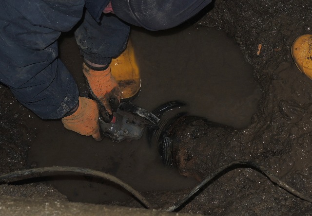 |
| Abb. 11: Auftrennen der Gummiringe mit einem Trennschleifer. Cut open the rubber rings with an abrasive cutter. (FB) |
 |
| Abb. 12: Reparaturmuffe (FB) |
 |
| Abb. 13: bereit zur Montage der Reparaturmuffe ready for mounting the repair sleeve 17:07 (FB) |
 |
| Abb. 13a: einen Tag später. Die Baugrube wird mit Sand verfüllt. one day later. The excavation pit is filled with sand. (FB) |
GPS-Daten für Luftbild 2016-11-30-rohrbruch-berliner-strasse.kmz
 |
| Abb. 14: Rohdaten: Track und Wegepunkte (FB) |
 |
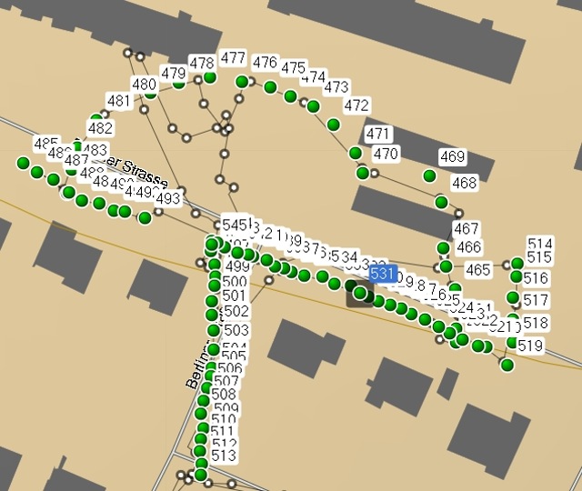
| Abb. 15: hellgrün: automatisch protokollierter Weg. gelb: nach den GPS-Daten (Track) markierte radiale Linien. lila: mit Wegepunkten markierte Abschnitte von Kreisen markierte Punke: Orte mit erhöht spürbarer Intensität Maßstab: 50 Meter zwischen den beiden Punkten unten Der gefundene Halbkreis hat einen Radius von 36 m. light green: automatically logged path. yellow: radial lines marked according to the GPS data (track). purple: sections of circles marked with waypoints. marked points: places with increased perceptible intensity scale: 50 metres between the two points below The semicircle found has a radius of 36 metres. https://opentopomap.org/#map=17/51.80756/10.33175 (FB) |
 |
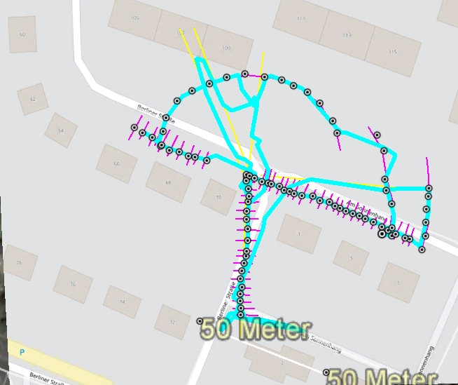
| Abb. 16: Die Struktur besteht vermutlich aus Kreisen und radialen Strahlen. Die im freiem Gelände abgelaufene obere Kurve entspricht tatsächlich einem halben Kreis! Dabei führte der Weg von rechts kommend über einen Parkplatz (470), dann nach dem siebten Punkt (477) um eine Böschung (Abb. 03 rechts oben) herum auf ein erhöhtes Niveau (478) direkt vor dem Wohngebäude (rechts in Abb. 01) entlang. Danach ging es weiter bis über die Berliner Straße (484) hinaus. Länge des Gebäudes 105 bis 109 (oben) : 52 m. The structure probably consists of circles and radial rays. The upper curve run off in the open ground actually corresponds to half a circle! Here the path, coming from the right, led across a car park (470), then after the seventh point (477) around an embankment (Fig. 03 top right) to a raised level (478) directly in front of the residential building (right in Fig. 01). It then continued to beyond Berliner Strasse (484). Length of building 105 to 109 (above) : 52 m. https://opentopomap.org/#map=17/51.80756/10.33175 (FB) |
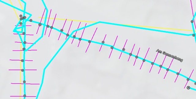 |
| Abb. 16: Abstand der konzentrischen Ringe etwa 3 m Distance of the concentric rings about 3 m (FB) |
 |
| Abb. 17: Es ist noch zu überprüfen, ob es sich um die gleiche Struktur wie bei einem Sender handelt. It still needs to be checked whether it is the same structure as a transmitter. (FB) |
 |
| Abb.
18: Eine Karstquelle in Franken. Sie soll unregelmäßig im Abstand von
mehreren Jahren und dann nur kurzzeitig Wasser an die Oberfläche
gebracht haben. Die Strukturen der Hohlräume (mit Wasser gefüllt?)
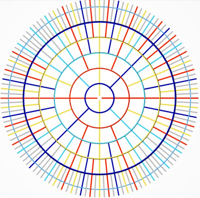
waren auch bei Trockenheit zu spüren. A karst spring in Franconia. It is said to have brought water to the surface irregularly at intervals of several years and then only for a short time. The structures of the cavities (filled with water?) were perceived even during dry periods. aus kuehlwasser-acht.htm#acht-05 Abb. 38: Blinde Quelle, es gibt kreisförmige und radiale Zonen. |
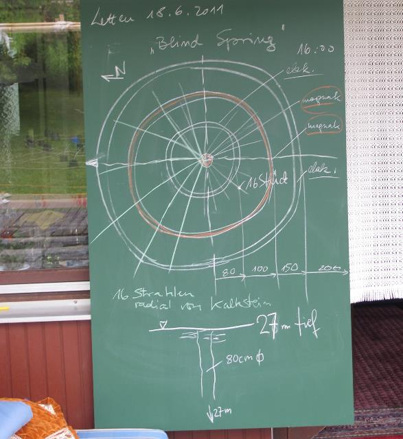 |
| Abb. 19: Blinde Quelle, blind spring aus kuehlwasser-acht.htm#acht-05 Abb. 43: Ergebnisse der Mutungen: 16 Zonen radial nach außen, sowie Kreisringe. |
01.12.2016, zweiter Schaden neben dem reparierten Bruch?
Zeit für die Datenaufnahme: 6 Minuten
 |
| Abb.
20: Genau in der Bildmitte befindet sich ebenfalls ein Zentrum von
spürbaren Strukturen mit radialen und konzentrischen Elementen. Im
Hintergrund links oben ist die Baustelle vom 30.11.2016 im Nebel zu
erahnen. Exactly in the centre of the image there is also a centre of perceptible structures with radial and concentric elements. In the upper left background, the construction site of 30.11.2016 can be guessed in the fog. (FB) |
 |
| Abb. 21: Radiale und kreisförmige Strukturen https://opentopomap.org/#map=17/51.80756/10.33175 (FB) |
 |
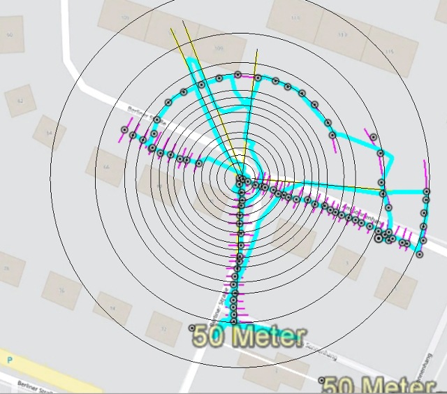
| Abb. 22: Bei Nebel ist die Genauigkeit der GPS-Messung geringer. Es wurden zwei Halbkreise und fünf radiale Elemente verfolgt. Bei dem größeren Bogen ist zu vermuten, daß es unterschiedliche Viertelkreise sind. Länge des Gebäudes 105 bis 109: 52 m. In fog, the accuracy of the GPS measurement is lower. Two semicircles and five radial elements were tracked. The larger arc can be assumed to be different quarter circles. Length of the building 105 to 109: 52 m. https://opentopomap.org/#map=17/51.80756/10.33175 (FB) |
GPS-Koordinaten der markierte Punkte
Zeit für die Suche: von 9:29 bis 9:42 insgesamt 13 Minuten
463 30-NOV-16 9:29:03 N51 48 21.8 E10 19 45.2 547 m
464 30-NOV-16 9:29:09 N51 48 21.9 E10 19 45.2 551 m
465 30-NOV-16 9:29:16 N51 48 22.2 E10 19 45.2 556 m
466 30-NOV-16 9:29:21 N51 48 22.3 E10 19 45.0 559 m
467 30-NOV-16 9:29:26 N51 48 22.4 E10 19 45.0 561 m
468 30-NOV-16 9:29:38 N51 48 22.8 E10 19 45.0 566 m
469 30-NOV-16 9:29:43 N51 48 23.0 E10 19 44.9 568 m
470 30-NOV-16 9:30:00 N51 48 23.0 E10 19 44.1 571 m
471 30-NOV-16 9:30:06 N51 48 23.1 E10 19 44.0 572 m
472 30-NOV-16 9:30:12 N51 48 23.3 E10 19 43.8 573 m
473 30-NOV-16 9:30:18 N51 48 23.4 E10 19 43.6 573 m
474 30-NOV-16 9:30:23 N51 48 23.5 E10 19 43.3 573 m
475 30-NOV-16 9:30:29 N51 48 23.6 E10 19 43.1 573 m
476 30-NOV-16 9:30:38 N51 48 23.6 E10 19 42.8 573 m
477 30-NOV-16 9:31:04 N51 48 23.7 E10 19 42.4 575 m
478 30-NOV-16 9:31:11 N51 48 23.6 E10 19 42.0 575 m
479 30-NOV-16 9:31:17 N51 48 23.5 E10 19 41.7 574 m
480 30-NOV-16 9:31:24 N51 48 23.5 E10 19 41.4 574 m
481 30-NOV-16 9:31:31 N51 48 23.4 E10 19 41.1 573 m
482 30-NOV-16 9:31:38 N51 48 23.2 E10 19 40.9 571 m
483 30-NOV-16 9:31:43 N51 48 23.0 E10 19 40.8 572 m
484 30-NOV-16 9:31:48 N51 48 22.8 E10 19 40.8 572 m
485 30-NOV-16 9:32:03 N51 48 23.0 E10 19 40.3 573 m
486 30-NOV-16 9:32:09 N51 48 23.0 E10 19 40.4 573 m
487 30-NOV-16 9:32:14 N51 48 22.9 E10 19 40.6 572 m
488 30-NOV-16 9:32:20 N51 48 22.8 E10 19 40.8 572 m
489 30-NOV-16 9:32:25 N51 48 22.8 E10 19 40.9 572 m
490 30-NOV-16 9:32:30 N51 48 22.8 E10 19 41.1 572 m
491 30-NOV-16 9:32:35 N51 48 22.7 E10 19 41.3 572 m
492 30-NOV-16 9:32:40 N51 48 22.7 E10 19 41.4 572 m
493 30-NOV-16 9:32:46 N51 48 22.7 E10 19 41.7 572 m
494 30-NOV-16 9:34:09 N51 48 22.5 E10 19 42.4 571 m
495 30-NOV-16 9:34:11 N51 48 22.5 E10 19 42.4 571 m
496 30-NOV-16 9:34:19 N51 48 22.4 E10 19 42.4 571 m
497 30-NOV-16 9:34:23 N51 48 22.3 E10 19 42.4 571 m
498 30-NOV-16 9:34:28 N51 48 22.2 E10 19 42.5 571 m
499 30-NOV-16 9:34:32 N51 48 22.2 E10 19 42.4 571 m
500 30-NOV-16 9:34:37 N51 48 22.1 E10 19 42.4 570 m
501 30-NOV-16 9:34:41 N51 48 22.0 E10 19 42.4 569 m
502 30-NOV-16 9:34:47 N51 48 21.9 E10 19 42.4 569 m
503 30-NOV-16 9:34:52 N51 48 21.7 E10 19 42.4 569 m
504 30-NOV-16 9:34:57 N51 48 21.6 E10 19 42.4 569 m
505 30-NOV-16 9:35:01 N51 48 21.5 E10 19 42.4 568 m
506 30-NOV-16 9:35:06 N51 48 21.5 E10 19 42.4 568 m
507 30-NOV-16 9:35:11 N51 48 21.4 E10 19 42.3 567 m
508 30-NOV-16 9:35:16 N51 48 21.3 E10 19 42.3 568 m
509 30-NOV-16 9:35:21 N51 48 21.2 E10 19 42.3 568 m
510 30-NOV-16 9:35:26 N51 48 21.1 E10 19 42.3 566 m
511 30-NOV-16 9:35:31 N51 48 21.0 E10 19 42.3 567 m
512 30-NOV-16 9:35:35 N51 48 20.9 E10 19 42.3 566 m
513 30-NOV-16 9:35:39 N51 48 20.8 E10 19 42.3 566 m
514 30-NOV-16 9:39:11 N51 48 22.3 E10 19 45.9 576 m
515 30-NOV-16 9:39:17 N51 48 22.2 E10 19 45.8 576 m
516 30-NOV-16 9:39:24 N51 48 22.1 E10 19 45.8 575 m
517 30-NOV-16 9:39:30 N51 48 21.9 E10 19 45.8 575 m
518 30-NOV-16 9:39:36 N51 48 21.8 E10 19 45.8 574 m
519 30-NOV-16 9:39:42 N51 48 21.6 E10 19 45.7 574 m
520 30-NOV-16 9:39:54 N51 48 21.7 E10 19 45.5 574 m
521 30-NOV-16 9:40:00 N51 48 21.8 E10 19 45.4 574 m
522 30-NOV-16 9:40:05 N51 48 21.8 E10 19 45.2 574 m
523 30-NOV-16 9:40:10 N51 48 21.8 E10 19 45.1 574 m
524 30-NOV-16 9:40:15 N51 48 21.9 E10 19 45.0 574 m
525 30-NOV-16 9:40:20 N51 48 21.9 E10 19 44.8 574 m
526 30-NOV-16 9:40:25 N51 48 22.0 E10 19 44.7 574 m
527 30-NOV-16 9:40:30 N51 48 22.0 E10 19 44.5 574 m
528 30-NOV-16 9:40:35 N51 48 22.0 E10 19 44.4 574 m
529 30-NOV-16 9:40:40 N51 48 22.1 E10 19 44.3 574 m
530 30-NOV-16 9:40:44 N51 48 22.1 E10 19 44.2 573 m
531 30-NOV-16 9:40:48 N51 48 22.1 E10 19 44.1 574 m
532 30-NOV-16 9:40:53 N51 48 22.2 E10 19 44.0 574 m
533 30-NOV-16 9:40:58 N51 48 22.2 E10 19 43.8 573 m
534 30-NOV-16 9:41:04 N51 48 22.2 E10 19 43.7 573 m
535 30-NOV-16 9:41:11 N51 48 22.3 E10 19 43.5 573 m
536 30-NOV-16 9:41:18 N51 48 22.3 E10 19 43.3 573 m
537 30-NOV-16 9:41:23 N51 48 22.3 E10 19 43.2 573 m
538 30-NOV-16 9:41:32 N51 48 22.3 E10 19 43.1 573 m
539 30-NOV-16 9:41:38 N51 48 22.4 E10 19 43.0 573 m
540 30-NOV-16 9:41:42 N51 48 22.4 E10 19 42.9 573 m
541 30-NOV-16 9:41:52 N51 48 22.4 E10 19 42.8 572 m
542 30-NOV-16 9:41:56 N51 48 22.4 E10 19 42.7 572 m
543 30-NOV-16 9:42:01 N51 48 22.5 E10 19 42.6 572 m
544 30-NOV-16 9:42:06 N51 48 22.5 E10 19 42.5 572 m
545 30-NOV-16 9:42:11 N51 48 22.5 E10 19 42.4 572 m
Zeit für die Datenaufnahme: 6 Minuten
001 01-DEZ-16 12:00:54 N51 48 23.1 E10 19 40.8 581 m
002 01-DEZ-16 12:01:00 N51 48 23.2 E10 19 41.0 581 m
003 01-DEZ-16 12:01:04 N51 48 23.3 E10 19 41.2 580 m
004 01-DEZ-16 12:01:09 N51 48 23.5 E10 19 41.4 580 m
005 01-DEZ-16 12:01:15 N51 48 23.6 E10 19 41.5 580 m
006 01-DEZ-16 12:01:23 N51 48 23.8 E10 19 41.7 582 m
007 01-DEZ-16 12:01:34 N51 48 23.9 E10 19 41.2 580 m
008 01-DEZ-16 12:01:40 N51 48 23.8 E10 19 41.1 580 m
009 01-DEZ-16 12:01:47 N51 48 23.6 E10 19 41.1 582 m
010 01-DEZ-16 12:01:53 N51 48 23.5 E10 19 41.0 582 m
011 01-DEZ-16 12:01:59 N51 48 23.2 E10 19 40.9 581 m
012 01-DEZ-16 12:02:01 N51 48 23.1 E10 19 40.9 579 m
013 01-DEZ-16 12:02:06 N51 48 23.1 E10 19 40.7 579 m
014 01-DEZ-16 12:02:11 N51 48 23.3 E10 19 40.6 578 m
015 01-DEZ-16 12:02:17 N51 48 23.4 E10 19 40.3 579 m
016 01-DEZ-16 12:02:22 N51 48 23.5 E10 19 40.1 580 m
017 01-DEZ-16 12:02:29 N51 48 23.7 E10 19 39.8 577 m
018 01-DEZ-16 12:02:42 N51 48 23.6 E10 19 39.3 581 m
019 01-DEZ-16 12:02:48 N51 48 23.5 E10 19 39.5 581 m
020 01-DEZ-16 12:02:54 N51 48 23.4 E10 19 39.8 579 m
021 01-DEZ-16 12:03:00 N51 48 23.3 E10 19 40.1 579 m
022 01-DEZ-16 12:03:05 N51 48 23.2 E10 19 40.4 580 m
023 01-DEZ-16 12:03:10 N51 48 23.1 E10 19 40.6 581 m
024 01-DEZ-16 12:03:15 N51 48 23.1 E10 19 40.8 580 m
025 01-DEZ-16 12:03:22 N51 48 23.0 E10 19 41.1 580 m
026 01-DEZ-16 12:03:27 N51 48 23.0 E10 19 41.5 579 m
027 01-DEZ-16 12:03:32 N51 48 23.0 E10 19 41.7 579 m
028 01-DEZ-16 12:03:36 N51 48 23.0 E10 19 42.0 579 m
029 01-DEZ-16 12:03:42 N51 48 23.1 E10 19 42.3 578 m
030 01-DEZ-16 12:03:49 N51 48 22.9 E10 19 42.3 578 m
031 01-DEZ-16 12:03:54 N51 48 23.0 E10 19 42.3 578 m
032 01-DEZ-16 12:04:05 N51 48 23.3 E10 19 42.1 580 m
033 01-DEZ-16 12:04:11 N51 48 23.3 E10 19 42.0 580 m
034 01-DEZ-16 12:04:17 N51 48 23.4 E10 19 41.9 581 m
035 01-DEZ-16 12:04:23 N51 48 23.6 E10 19 41.7 581 m
036 01-DEZ-16 12:04:27 N51 48 23.6 E10 19 41.5 581 m
037 01-DEZ-16 12:04:32 N51 48 23.6 E10 19 41.2 582 m
038 01-DEZ-16 12:04:38 N51 48 23.7 E10 19 40.9 582 m
039 01-DEZ-16 12:04:43 N51 48 23.6 E10 19 40.7 582 m
040 01-DEZ-16 12:04:48 N51 48 23.6 E10 19 40.5 581 m
041 01-DEZ-16 12:04:52 N51 48 23.6 E10 19 40.4 581 m
042 01-DEZ-16 12:04:57 N51 48 23.5 E10 19 40.2 579 m
043 01-DEZ-16 12:05:01 N51 48 23.4 E10 19 40.1 581 m
044 01-DEZ-16 12:05:06 N51 48 23.3 E10 19 39.9 579 m
045 01-DEZ-16 12:05:11 N51 48 23.2 E10 19 39.8 581 m
046 01-DEZ-16 12:05:54 N51 48 23.0 E10 19 40.5 580 m
047 01-DEZ-16 12:06:01 N51 48 23.1 E10 19 40.5 580 m
048 01-DEZ-16 12:06:06 N51 48 23.3 E10 19 40.5 580 m
049 01-DEZ-16 12:06:11 N51 48 23.4 E10 19 40.6 580 m
050 01-DEZ-16 12:06:15 N51 48 23.5 E10 19 40.7 580 m
051 01-DEZ-16 12:06:20 N51 48 23.4 E10 19 40.9 580 m
052 01-DEZ-16 12:06:25 N51 48 23.4 E10 19 41.1 580 m
053 01-DEZ-16 12:06:30 N51 48 23.3 E10 19 41.2 579 m
054 01-DEZ-16 12:06:35 N51 48 23.1 E10 19 41.3 579 m
055 01-DEZ-16 12:06:39 N51 48 23.0 E10 19 41.3 579 m
056 01-DEZ-16 12:06:43 N51 48 22.9 E10 19 41.3 579 m
057 01-DEZ-16 12:06:47 N51 48 22.8 E10 19 41.3 579 m
058 01-DEZ-16 12:06:50 N51 48 22.8 E10 19 41.2 579 m
01.08.2023
Bei einem dünnen Strahl gibt es eine weitreichende spürbare Struktur (15 m) etwa in der Form wie die Speichen bei einem Rad.
Ähnlich wie in Abb. 19 bei einer "BLIND SPRING"
With a thin jet, there is a long-range perceptible structure (15 m) roughly in the shape of the spokes on a wheel.
Similar to Fig. 19 with a "BLIND SPRING".
 |
| Abb. 02-01: Rohrbruch in Lehmboden Pipe burst in clay soil (FB) |
 |
| Abb. 02-02: Es ist ein feiner Strahl (Bleistiftdicke) Die spürbaren Strukturen auf dem Gelände sind wie Speichen von einem Rad angeordnet. (siehe Abb. 19) It is a fine beam (pencil thickness). The perceptible structures on the terrain are arranged like spokes from a wheel. (see fig. 19) (FB) |
 |
| Abb. 02-03: Zum Ablassen des Drucks ist das Hausanschlußrohr angeschnitten. Bei diesem aufgefächerten flachen Strahl gibt es keine Speichen wie bei einem Rad. Es ist alles diffus verteilt, wenig strukturiert. The house connection pipe is cut to release the pressure. With this fanned-out flat jet, there are no spokes like on a wheel. It is all diffusely distributed, little structured. (FB) |
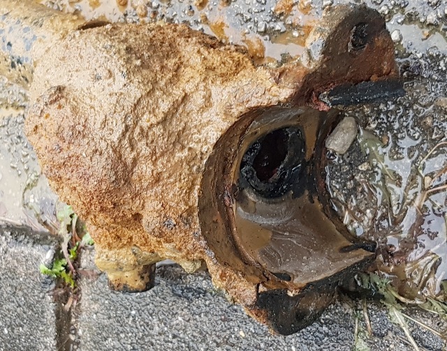 |
| Abb. 02-04: Der Grund für den Schaden: die
zweiteilige Anbohrschelle umschloß das Kunststoffrohr nicht mehr
vollständig. Eine der beiden Halteschrauben was durchgerostet. The reason for the damage: the two-part tapping clamp no longer completely enclosed the plastic pipe. One of the two retaining screws was rusted through. (FB) |
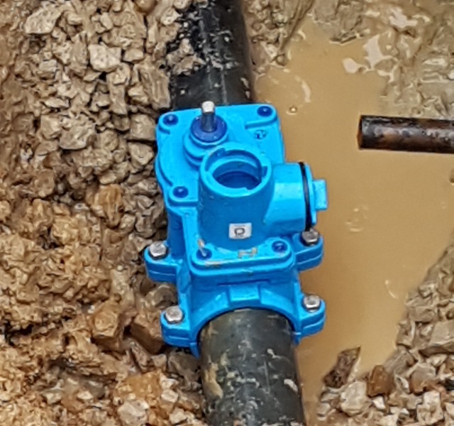 |
| Abb. 02-05: Die neue Armatur ist am Rohr befestigt. Jetzt fehlt nur noch die Verbindung zum Haus nach rechts. The new fitting is attached to the pipe. Now only the connection to the house to the right is missing.(FB) |
Literatur: b-literatur.htm
 |
www.biosensor-physik.de | (c) 30.11.2016 - 15.08.2023 F.Balck |
© BioSensor-Physik 2023
· Impressum