Beobachtungen:
Psi-Ringabstand
Psi distance of the circles
zum Verteiler Psi-Track und zu den anderen Psi-Track-Seiten
to the main page and other psi-track pages psi-track-000
Das spürbare Muster um ein Objekt herum sollte aus konzentrischen Ringen und radial verlaufenden Linien bestehen (Abb. 01), so haben es die Resonanz-Experimente mit Bernsteinproben und Wachskerzen ergeben. bernstein-resonanz nosode
Gilt diese Beobachtung auch für Objekte ohne Resonanzantenne, d.h. einen mental abgestimmten Partner für die Resonanz?
Hierzu wurden drei Experimente nach der natürlichen Methode durchgeführt, d.h. nur mit "mentaler Zielansprache":
1. Fahrrad, in Sichtweite, Gelände bergauf, leichter Seitenwind, eigenes Fahrrad, Start-Entfernung größer als 200 Meter
2. Auto, in Sichtweite, enge Straße zwischen Wohnhäusern, eigenes Fahrzeug, Start-Entfernung größer als 300 Meter
3. Fahrrad, in Sichtweite, Gelände horizontal, eigenes Fahrrad
4. Fahrrad, in Sichtweite, Gelände leicht geneigt, eigenes Fahrrad, drei Standorte nacheinander,
jeweils zwei entgegengesetzte Richtungen
The
observable
pattern
around an object
should consist of concentric rings and
radially running lines (fig. 01). This is result of the resonance
experiments with amber samples and candles. bernstein-resonanz
nosode
Is this observation valid also for objects without resonance antenna, i.e. for a mental tuned partner for the resonance?
For this three experiments were accomplished according to the natural method, i.e. only with “mental target acquisition”:
1. Bicycle, in range of vision, area uphill, more easily cross-wind, own bicycle,
4. Bicycle, in range of vision, area easily inclined, own bicycle, three locations successively,
in each case two opposite directions
Is this observation valid also for objects without resonance antenna, i.e. for a mental tuned partner for the resonance?
For this three experiments were accomplished according to the natural method, i.e. only with “mental target acquisition”:
1. Bicycle, in range of vision, area uphill, more easily cross-wind, own bicycle,
starting
distance more largely than 200
meters
2. Car,
in range of vision,
confined street between houses, own vehicle, starting
distance more largely than 300
meters
3.
Bicycle, in range of vision, area
horizontal, own bicycle4. Bicycle, in range of vision, area easily inclined, own bicycle, three locations successively,
in each case two opposite directions
Strategie
Damit das Experiment möglichst objektiv ablaufen kann, wurde die Richtung für die Suche von außen nach innen, also zum Ziel hin gewählt. Die Strecke wurde jeweils nur einmal begangen. Daher erscheint es ausgeschlossen, daß der Beobachter durch Abzählen seiner eigenen Schritte das beobachtete Muster hätte produzieren können.
Bei dieser Gehrichtung läßt sich das Problem der Kreuzungspunkte mit den radialen Strahlen vermeiden, indem man zunächst einen radialen Strahl sucht und dann daneben, also "zwischen" den Strahlen direkt auf das Ziel zugeht.
Würde man über Kreuzungspunkte gehen, könnte die möglichen Auslöschung durch Überlagerung die ermittelte Punktreihe teilweise unvollständig erscheinen lassen.
Alle Beobachtungen erfolgten nach der natürlichen Methode, d.h. ohne Hilfsmittel wie eine Rute.
Die Koordinaten der gefundenen Ringpositionen wurden nachvollziehbar per GPS mit Datum und Uhrzeit protokolliert.
Strategy
So that the experiment can run off as objectively as possible, the direction for the search was selected from outside to inside, thus to the target. The path to the target was went in each case only once. So it appears impossible that the observer could have produced the observed pattern by counting his own steps.
Going towards the target is a possibility to avoid the problem of the crossovers with the radial lines. First looking for a radial line and then going beside it, thus "between" the lines directly toward the target.
If one would go over crossovers, a possible extinction could be undetermined, so that the data set would be partly incomplete.
All observations took place according to the natural method, i.e. without aids like a rod.
The coordinates of the found ring positions were logged comprehensibly by GPS with date and time
Ergebnis Result
Ebenso wie bei dem Bernsteinexperiment läßt sich ein quadratisches Zunehmen der Ringradien mit größerer Entfernung vom Mittelpunkt nachweisen.
Just
as with the amber experiment a square increase of the ring radii with
larger distance of the center was found.
Die Steigungen der Geraden Wurzel(Abstand) gegen Index in Wurzel(Meter) ergeben folgende Werte:
The
gradients of the straight line root (distance)
against index are:
Bernstein amber 0,83 0,94 0,97
Fahrrad bycicle 0,61 0,61 0,50 0,53 0,65 0,82 0,83 0,71
Auto car 1,41
Diese Beobachtung ist ein wichtiger Schlüssel für die Klärung des Mechanismus.
This
observation is an important key for clarifying the mechanism.
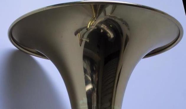 |
| Abb. 01: Schalltrichter einer
Posaune. Die Höhenlinien für diesen Trichter bilden
konzentrische Kreise um den Mittelpunkt. Hier gilt für die
mathematische Beschreibung eine Exponentialform. Acoustic horn of a trombone. The contours for this funnel form concentric circles around the center. The mathematical form is exponential. (FB) |
 |
| Abb. 01a: Wurzelfunktion y =
Wurzel (x) Annahme: Es gibt einen radialsymmetrischen Trichter wie in Abb. 01, dessen halber Querschnitt sich mit dieser Wurzelfunktion beschreiben läßt. Die roten Linien sollen aufeinander folgende Höhenlinien mit gleichem Abstand sein. Senkrecht von oben betrachtet sind es dann Kreise um den Mittelpunkt (bei x=0). Die Radien der Kreise bilden bei dieser Funktion eine Reihe von Quadratzahlen. In der Praxis ist die Einheit für die x-Achse Meter. Versuch einer physikalischen Deutung: Annahme: Es gibt einen Potentialtopf, bei dem für die Energie bzw. Frequenz als Funktion des Abstandes diese Wurzelfunktion gilt. Bewegt man nun von außen an dieses Potential einen passend abgestimmten Oszillator heran, der gleichzeitig in allen Harmonischen schwingt, dann gibt es bei den Positionen der blauen Linien jeweils Resonanz für eine Harmonische. (vergleichbar mit gequantelten Zuständen in einem Potentialtopf) Da die Ringe auch noch in über 100 Metern gut zu beobachten sind, dürfte beispielsweise ein Coulomb-Potential (elektrostatisches Feld) als Erklärung nicht in Frage kommen. Root function y = root (x) Hypothesis: There is a radialsymmetrical funnel as in fig. 01, whose half cross section lets itself describe with this root function. The red lines should be sequential contours with same distance. Perpendicularly regarded from above there are circles around the center (with x=0). The radii of the circles form a set of sqares with this function. In practice the unit for the x axis is meter. Attempt of a physical interpretation: Hypothesis: There is a potential well, with which this root function is valid for the energy and/or frequency as function of the distance. If one moves a suitably tuned oscillator, which swings at the same time in all harmonics, from the outside to the center of this potential, then there will be resonance for a single harmonic at each position of the blue lines. (comparably with quantized conditions in a potential well) Since the rings are well to be observed also still in over 100 meters, a coulomb potential (electrostatic field) for example might not be applicable as explanation. (FB) |
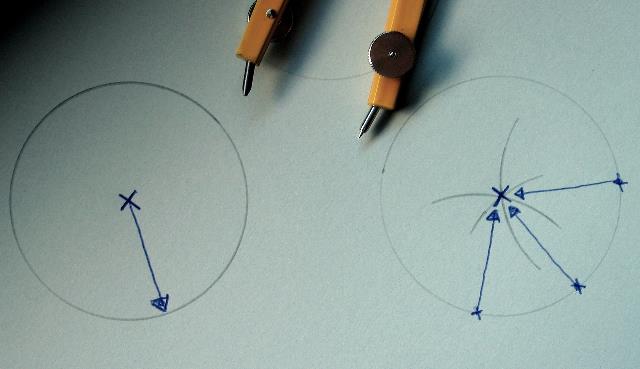 |
| Abb. 01b: Es gibt zwei
Möglichkeiten, einen Kreis zu erzeugen. links: von einem Punkt aus, dem Zentrum, sucht man alle Punkte, die einen bestimmten Abstand dazu haben. rechts: mehrere Kreise werden so gezeichnet, daß sie zu einem festen Punkt einen bestimmten Abstand haben, so als ob ein Rad um eine dünne Achse herum rollen würde. Die Mittelpunkte aller dieser Kreise liegen auf einem Kreis. Bei der Version links erfolgt die Aktion von innen nach außen, das Zentrum und der Radius bestimmen die Form des Kreises. bei der anderen Version ist die Aktionsrichtung umgekehrt. Die Abmessung des Rades gibt die Form des Kreises vor. Für die Psi-Ringe bedeutet der Unterschied beider Kreistypen: links: Der gesuchte Gegenstand wirkt als Sender und bestimmt die Lage der Kreise. rechts: Die suchende Person wirkt als Sender, der Gegenstand ist nur Empfänger, bzw. Reflektor. Aus den Beobachtungen von Abb. 18 und 20 sollte die rechte Version folgen, d.h. der Suchende ist der Sender. There are two possibilities of producing a circle. left: from one point, the center, one looks for all points, which have a certain distance to it. right: several circles are drawn so that they have a certain distance to a firm point, so as if a wheel would roll around a thin axle. The centers of all of these circles are on a circle. With the version left the action takes place from the inside outward, the center and the radius determines the form of the circle. At the other version the action direction is turned around. The size of the wheel gives the form of the circle. For the psi rings the difference of both circle types means: left: The looked for object works as sender and determines the situation of the circles. right: The searching person works as sender, the object is only receiver, and/or reflector. From the observations of figs. 18 and 20 however the right version should follow, i.e. the searching person is the sender. (FB) |
Parabel, quadratischer Zusammenhang
Die Zahlen n 1 2 3 4 5 6 7 8 9 10
Folge der Quadrate 1 4 9 16 25 36 49 64 81 100
läßt sich auch schreiben als 1 , 1 +3 , 1 +3 +5 , 1 + 3 + 5 + 7, 1 + 3+ 5 + 7 +9
oder allgemein neue Zahl = alte Zahl + vorherige Differenz + 2
Mathematisch gilt für den Abstand der Quadrate von n+1 und n:
(n+1) * (n+1) - n*n = 2n+1, dies sind also alle ungeraden Zahlen, oder anders geschrieben: 2 (1/2 + n)
möglicher Zusammenhang??
In der Quantenmechanik hat ein harmonischer Oszillator den Energiezustand n:
En= 2 * pi * h * ω (1/2 +n)
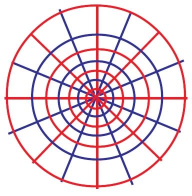 |
| Abb. 01: Schematische
Darstellung der spürbaren Zonen bei einem punktförmigen
Objekt (Ausschnitt). Es gibt bei Überlagerung von Ringen und radialen Strahlen jeweils Auslöschung oder Verstärkung (verschieden- oder gleichfarbig) Der Abstand der Ringe nimmt nach außen hin zu. Nach der Beobachtung gilt offensichtlich ein quadratisches Abstandgesetz. Schematic representation of the observable zones with a punctiform object (cutout). There is extinction or reinforcement (different or same colored) with overlay of rings and radial lines in each case The distance of the rings increases outward. After the observation obviously a square spacer law is valid. kreuzgitter (FB) |
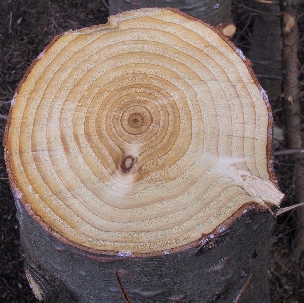 |
| Abb. 02: Bei einem Baum wachsen
die Jahresringe nicht gleichmäßig. Die von einem
Rutengänger spürbaren Ringe könnten vergleichbar sein
mit den großen Kontrastunterschieden im
Außenbereich eines jeden Ringes. An manchen Stellen sieht so aus, als wenn die inneren Ringe kleinere Abstände hätten als die äußeren. Dies hängt von den Bedingungen beim Wachsen ab. Die Äste bilden eine Störung in der regelmäßigen Struktur. Allerdings gilt hier nicht die Regel, daß die Ringbreite nach außen grundsätzlich zunimmt. Tree rings do not grow every year evenly. The observable rings by a dowser might be comparable with the large contrast differences in the external area of each tree ring. In some parts of this tree it looks, as if the internal rings would have smaller distances than the outer. This depends on the conditions when growing. The outgoing branches form disturbances in the regular structure. However the rule is not valid here, that in principle the difference between rings will increase going outwards. (FB) |
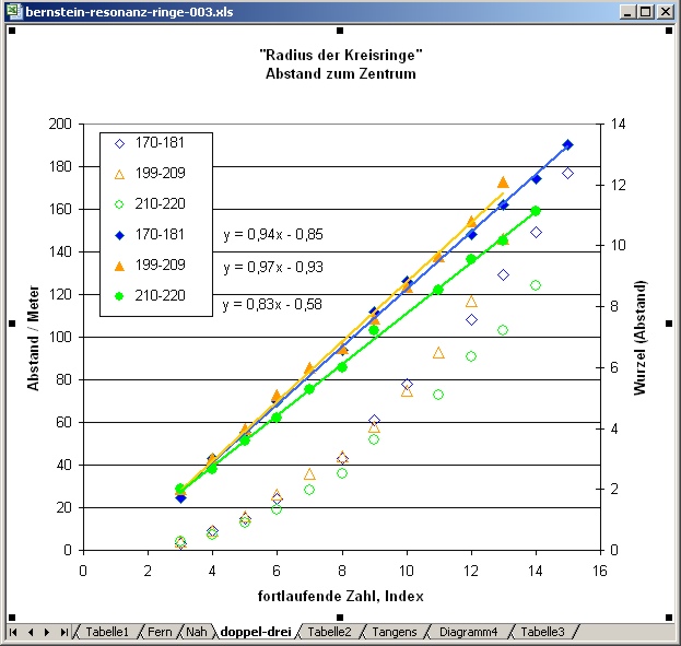 |
| Abb. 03: Radius der Ringe,
Abstand vom Zentrum gegen fortlaufende Zahl linke Achse: Meßdaten, beobachtete Entfernung (offene Symbole) rechte Achse: Meßdaten, Auftragung jedoch als Wurzel der Entfernung (geschlossene Symbole) Daten dreier unterschiedlicher Wege mit den Punkten 170 bis 181, 199 bis 209 und 210 bis 220 aus bernstein-resonanz Für die Punkte mit offenen Symbolen gilt offensichtlich eine quadratische Abhängigkeit, denn die Auftragung als Wurzel (Abstand) mit ausgefüllten Symbolen liefert Geraden. Die Steigungen der Geraden betragen 0,83 0,94 und 0,97 Wurzel(Meter). Radii of the rings, distance from the center against sequential number left scale: Measuring data, observed distance (open symbols) right scale: Measuring data, drawn as root of the distance (closed symbols) Data of three different ways with the points 170 to 181, 199 to 209 and 210 to 220 from bernstein-resonanz For the points with open symbols there is obviously a square dependence valid, because the sketch as root (distance) with filled out symbols supplies straight lines. The gradients of the straight lines amount to 0,83 0,94 and 0.97 root (meter). (FB) |
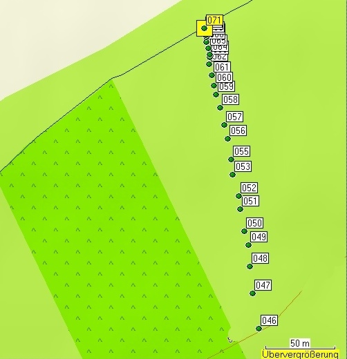
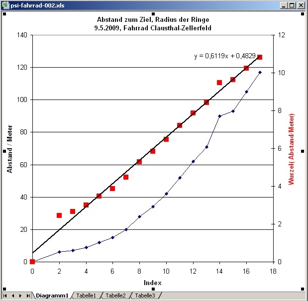
1. Experiment mit einem Fahrrad in Clausthal-Zellerfeld
Experiment with a bycicle in
Clausthal-Zellerfeld
Luftbild Aerial photograph http://maps.live.de/LiveSearch.LocalLive?
Die Daten wurden im Anschluß an psi-track-007 auf dem gleichen Gelände aufgenommen.
Das gedachte Ziel (mental) war ein Fahrrad.
The data were taken up following psi-track-007 on the same area.
The meant target (mental) was a bicycle.
 |
|||||||||||||||||||||||||||||||||||||||||||||||||||||||||||||||||||||||||||||||||||||||||||||||||||||||||||||||||||||||||||||||||||||||
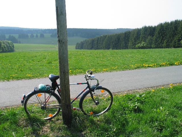
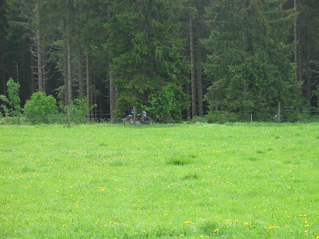
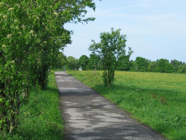
| Abb. 04: Das angestrebte Ziel,
das Fahrrad. Der Beginn der Suchstrecke liegt bergab in 200 Meter Entfernung. An diesem Mast hängt ein Telefonkabel The target, a bycicle. The beginning of the search path lies downhill into 200 meters distance. On this mast hangs a telephone line. (FB) |
|||||||||||||||||||||||||||||||||||||||||||||||||||||||||||||||||||||||||||||||||||||||||||||||||||||||||||||||||||||||||||||||||||||||
 |
|||||||||||||||||||||||||||||||||||||||||||||||||||||||||||||||||||||||||||||||||||||||||||||||||||||||||||||||||||||||||||||||||||||||
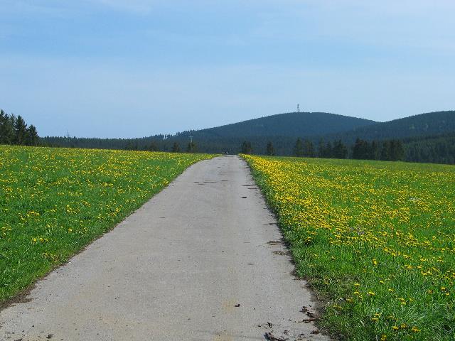
| Abb. 05: Die Suchstrecke, das
Ziel (Fahrrad) steht am Holzmast links von der Bildmitte. Looking from the sending point to the bycicle, it stands at the timber mast to the left of the picture center. (FB) |
|||||||||||||||||||||||||||||||||||||||||||||||||||||||||||||||||||||||||||||||||||||||||||||||||||||||||||||||||||||||||||||||||||||||
 |
|||||||||||||||||||||||||||||||||||||||||||||||||||||||||||||||||||||||||||||||||||||||||||||||||||||||||||||||||||||||||||||||||||||||
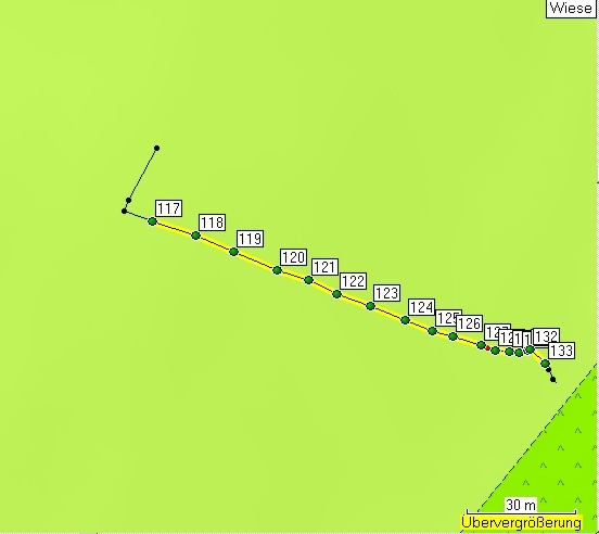
| Abb. 06: Die abgelaufene Strecke
mit den gespürten Positionen der Kreisringe um den Zielpunkt. The path with the marked positions of the found circles around the target. (FB) |
|||||||||||||||||||||||||||||||||||||||||||||||||||||||||||||||||||||||||||||||||||||||||||||||||||||||||||||||||||||||||||||||||||||||
| Tabelle der mit GPS
protokollierten Punkte im Gelände geologie-001 Name Datum Zeit Koordinate Höhe nach Luftdruckmessung 046 03-MAI-09 10:57:08 N51 47 30.3 E10 21 13.8 568 m 047 03-MAI-09 10:57:30 N51 47 31.1 E10 21 13.6 569 m 048 03-MAI-09 10:57:47 N51 47 31.7 E10 21 13.5 571 m 049 03-MAI-09 10:58:02 N51 47 32.2 E10 21 13.4 572 m 050 03-MAI-09 10:58:16 N51 47 32.5 E10 21 13.2 574 m 051 03-MAI-09 10:58:41 N51 47 33.0 E10 21 13.1 577 m 052 03-MAI-09 10:58:53 N51 47 33.4 E10 21 13.0 576 m 053 03-MAI-09 10:59:05 N51 47 33.9 E10 21 12.8 577 m 054 03-MAI-09 10:59:22 N51 47 34.2 E10 21 12.7 581 m 055 03-MAI-09 10:59:22 N51 47 34.2 E10 21 12.7 581 m 056 03-MAI-09 10:59:39 N51 47 34.7 E10 21 12.6 580 m 057 03-MAI-09 10:59:49 N51 47 35.0 E10 21 12.5 582 m 058 03-MAI-09 10:59:59 N51 47 35.4 E10 21 12.3 583 m 059 03-MAI-09 11:00:09 N51 47 35.7 E10 21 12.2 583 m 060 03-MAI-09 11:00:33 N51 47 36.0 E10 21 12.1 586 m 061 03-MAI-09 11:00:43 N51 47 36.2 E10 21 12.0 585 m 062 03-MAI-09 11:00:52 N51 47 36.5 E10 21 11.9 586 m 063 03-MAI-09 11:01:01 N51 47 36.6 E10 21 11.9 586 m 064 03-MAI-09 11:01:06 N51 47 36.7 E10 21 11.9 586 m 065 03-MAI-09 11:01:12 N51 47 36.8 E10 21 11.9 587 m 066 03-MAI-09 11:01:19 N51 47 37.0 E10 21 11.8 587 m 067 03-MAI-09 11:01:24 N51 47 37.1 E10 21 11.8 587 m 068 03-MAI-09 11:01:28 N51 47 37.1 E10 21 11.8 587 m 069 03-MAI-09 11:01:34 N51 47 37.2 E10 21 11.7 588 m 070 03-MAI-09 11:01:38 N51 47 37.3 E10 21 11.7 588 m 071 03-MAI-09 11:01:42 N51 47 37.3 E10 21 11.7 588 m (Fahrrad) Route mit errechneten Entfernungen route with distances calculated
|
|||||||||||||||||||||||||||||||||||||||||||||||||||||||||||||||||||||||||||||||||||||||||||||||||||||||||||||||||||||||||||||||||||||||
| Tabelle 01: Die original
GPS-Daten aller Punkte und die errechneten Entfernungen The original GPS-data and the calculated distances (FB) |
|||||||||||||||||||||||||||||||||||||||||||||||||||||||||||||||||||||||||||||||||||||||||||||||||||||||||||||||||||||||||||||||||||||||
 |
|||||||||||||||||||||||||||||||||||||||||||||||||||||||||||||||||||||||||||||||||||||||||||||||||||||||||||||||||||||||||||||||||||||||
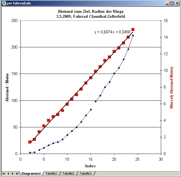
| Abb. 07: Auftragung der
Ringradien gegen fortlaufende Nummer. Die kleinen blauen Symbole entsprechen den tatsächlichen Radien, die roten den Quadratwurzeln aus den Werten. Offensichtlich lassen sich die roten Punkte mit einer Gerade annähern. Die Steigung der Geraden beträgt 0,607 Wurzel(Meter) Plot of the ring radii against sequential number. The small blue symbols correspond to the actual radii, the red to the square roots. The red points can obviously approximated with straight lines . The gradient of the straight lines amounts to 0.607 root (meter) (FB) |
|||||||||||||||||||||||||||||||||||||||||||||||||||||||||||||||||||||||||||||||||||||||||||||||||||||||||||||||||||||||||||||||||||||||
|
|||||||||||||||||||||||||||||||||||||||||||||||||||||||||||||||||||||||||||||||||||||||||||||||||||||||||||||||||||||||||||||||||||||||
| Tabelle 02: Die Daten zum
Diagramm in Abb. 04. (FB) |
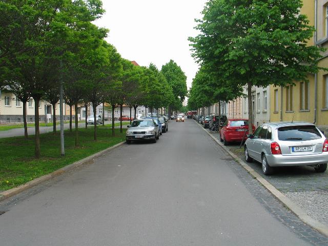
2. Experiment mit einem Auto in Erfurt
Experiment
with a car at Erfurt
Die Daten wurden im Anschluß an psi-track-005
aufgenommen.
siehe Luftbild, areal photo http://maps.live.de/LiveSearch.LocalLive?
Das gedachte Ziel (mental) war das eigene Auto.
 |
||||||||||||||||||||||||||||||||||||||||||||||||||||||||||||||||||||||||||||||||
| Abb. 08: Das angestrebte Ziel,
das eigene Auto, links von der
Bildmitte Erfurt, Rathenaustrasse The target is the silver car in the middle of the picture (FB) |
||||||||||||||||||||||||||||||||||||||||||||||||||||||||||||||||||||||||||||||||
 |
||||||||||||||||||||||||||||||||||||||||||||||||||||||||||||||||||||||||||||||||
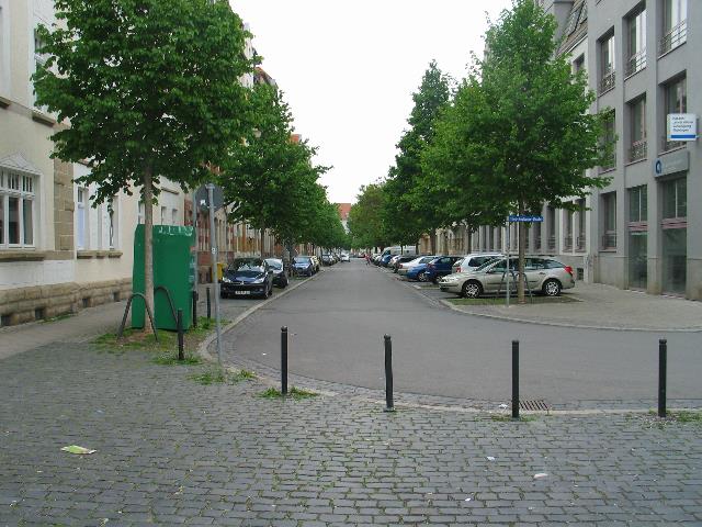
| Abb. 09: Blick zurück, auf
diesem Weg wurden die gespürten Ringpositionen bestimmt. Hinter
dem Fotografen steht das Auto in einigen Metern Entfernung. Erfurt, Rathenaustrasse View back, this was the way where the positions of the circles were determined. (FB) |
||||||||||||||||||||||||||||||||||||||||||||||||||||||||||||||||||||||||||||||||
 |
||||||||||||||||||||||||||||||||||||||||||||||||||||||||||||||||||||||||||||||||
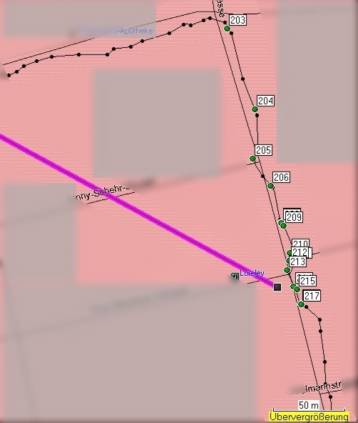
| Abb. 10: Die gespürten
Positionen im Lageplan. Einige Punkte sind sehr nahe beieinander,
mehrfach ausgelöst worden. (gespürte Störungen von
Einbauten in der Straße?) Auf dem Weg in Richtung Punkt 203 waren auf der Straße auch mehrere radial auf das Objekt zulaufende Zonen zu spüren. Erfurt, Rathenaustrasse Groundplan with the observed positions. Some of them are near together (possible doublets). In the near of point 203 there were some zones with disturbances. (FB) |
||||||||||||||||||||||||||||||||||||||||||||||||||||||||||||||||||||||||||||||||
| Tabelle der mit GPS
protokollierten Punkte im Gelände geologie-001 Name Datum Zeit Koordinate Höhe nach Luftdruckmessung 203 02-MAI-09 14:38:16 N50 58 52.8 E11 02 41.3 194 m 204 02-MAI-09 14:38:55 N50 58 51.0 E11 02 42.3 194 m 205 02-MAI-09 14:39:29 N50 58 49.9 E11 02 42.2 193 m 206 02-MAI-09 14:39:41 N50 58 49.3 E11 02 42.9 195 m 207 02-MAI-09 14:39:59 N50 58 48.5 E11 02 43.2 196 m 208 02-MAI-09 14:40:07 N50 58 48.4 E11 02 43.3 195 m 209 02-MAI-09 14:40:15 N50 58 48.4 E11 02 43.3 197 m 210 02-MAI-09 14:40:24 N50 58 47.8 E11 02 43.6 196 m 211 02-MAI-09 14:40:31 N50 58 47.6 E11 02 43.7 196 m 212 02-MAI-09 14:40:37 N50 58 47.6 E11 02 43.5 196 m 213 02-MAI-09 14:41:22 N50 58 47.4 E11 02 43.5 195 m 214 02-MAI-09 14:41:29 N50 58 47.0 E11 02 43.7 196 m 215 02-MAI-09 14:41:34 N50 58 46.9 E11 02 43.8 196 m 216 02-MAI-09 14:42:01 N50 58 46.6 E11 02 43.9 196 m 217 02-MAI-09 14:42:03 N50 58 46.6 E11 02 44.0 197 m (Auto) Route mit errechneten Entfernungen
|
||||||||||||||||||||||||||||||||||||||||||||||||||||||||||||||||||||||||||||||||
| Tabelle 03: Die original
GPS-Daten (FB) |
||||||||||||||||||||||||||||||||||||||||||||||||||||||||||||||||||||||||||||||||
 |
||||||||||||||||||||||||||||||||||||||||||||||||||||||||||||||||||||||||||||||||
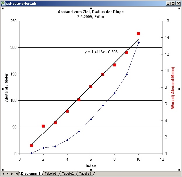
| Abb. 11: Auftragung der
Ringradien gegen fortlaufende Nummer. Die kleinen blauen Symbole entsprechen den tatsächlichen Radien, die roten den Quadratwurzeln aus den Werten. Offensichtlich lassen sich die roten Punkte mit einer Gerade annähern. Die Steigung der Geraden beträgt 1,412 Wurzel(Meter) Plot of the ring radii against sequential number. The small blue symbols correspond to the actual radii, the red to the square roots. The red points can obviously approximated with straight lines . The gradient of the straight lines amounts to 1.412 root (meter) (FB) |
||||||||||||||||||||||||||||||||||||||||||||||||||||||||||||||||||||||||||||||||
|
||||||||||||||||||||||||||||||||||||||||||||||||||||||||||||||||||||||||||||||||
| Tabelle 04: Die Daten zum Diagramm in Abb. 04. (FB) |
Zweiter Versuch mit dem Fahrrad
Second
experiment with a bycicle
Luftbild, areal
view
http://maps.live.de/LiveSearch.LocalLive?
interaktives Luftbild mit GoogleEarth
psi-track-009c.kmz
http://maps.live.de/LiveSearch.LocalLive?
interaktives Luftbild mit GoogleEarth
psi-track-009c.kmz
 |
||||||||||||||||||||||||||||||||||||||||||||||||||||||||||||||||||||||||||||||||||||||||||
| Abb. 12: Das Ziel, das Fahrrad
the target is a bycicle
(FB) |
||||||||||||||||||||||||||||||||||||||||||||||||||||||||||||||||||||||||||||||||||||||||||
 |
||||||||||||||||||||||||||||||||||||||||||||||||||||||||||||||||||||||||||||||||||||||||||
| Abb. 13: Markierte Punkte, das
Ziel steht bei Punkt 133 Marked points, the target is at no. 133 (FB) |
||||||||||||||||||||||||||||||||||||||||||||||||||||||||||||||||||||||||||||||||||||||||||
Tabelle der mit GPS protokollierten Punkte im Gelände geologie-001 Name Datum Zeit Koordinate Höhe nach Luftdruckmessung 117 09-MAI-09 11:23:11 N51 47 18.0 E10 21 28.8 576 m 118 09-MAI-09 11:23:24 N51 47 17.9 E10 21 29.4 577 m 119 09-MAI-09 11:23:37 N51 47 17.8 E10 21 30.0 577 m 120 09-MAI-09 11:23:49 N51 47 17.6 E10 21 30.6 578 m 121 09-MAI-09 11:23:58 N51 47 17.5 E10 21 31.0 578 m 122 09-MAI-09 11:24:06 N51 47 17.4 E10 21 31.5 578 m 123 09-MAI-09 11:24:16 N51 47 17.3 E10 21 31.9 580 m 124 09-MAI-09 11:24:27 N51 47 17.2 E10 21 32.4 579 m 125 09-MAI-09 11:24:36 N51 47 17.1 E10 21 32.8 581 m 126 09-MAI-09 11:24:45 N51 47 17.0 E10 21 33.1 581 m 127 09-MAI-09 11:24:54 N51 47 16.9 E10 21 33.5 582 m 128 09-MAI-09 11:25:01 N51 47 16.9 E10 21 33.8 582 m 129 09-MAI-09 11:25:08 N51 47 16.9 E10 21 34.0 582 m 130 09-MAI-09 11:25:13 N51 47 16.9 E10 21 34.1 582 m 131 09-MAI-09 11:25:20 N51 47 16.9 E10 21 34.2 582 m 132 09-MAI-09 11:25:26 N51 47 16.9 E10 21 34.2 582 m 133 09-MAI-09 11:25:34 N51 47 16.8 E10 21 34.5 581 m Route mit errechneten Entfernungen route and calculated distances
|
||||||||||||||||||||||||||||||||||||||||||||||||||||||||||||||||||||||||||||||||||||||||||
| Tabelle 05: Protokoll der GPS
Daten, und errechnete Entfernungen der Routenpunkte vom Ziel (FB) |
||||||||||||||||||||||||||||||||||||||||||||||||||||||||||||||||||||||||||||||||||||||||||
 |
||||||||||||||||||||||||||||||||||||||||||||||||||||||||||||||||||||||||||||||||||||||||||
| Abb. 14: Auftragung der
Ringradien gegen fortlaufenden Index. blau: die gemessenen Abstände, rot: Wurzel aus den Abständen Die Steigung der Geraden beträgt 0,612 Wurzel(Meter) Plot of the ring radii against sequential index. The small blue symbols correspond to the actual radii, the red to the square roots. The red points can obviously approximated with straight lines . The gradient of the straight lines amounts to 0.612 root (meter) (FB) |
||||||||||||||||||||||||||||||||||||||||||||||||||||||||||||||||||||||||||||||||||||||||||
|
||||||||||||||||||||||||||||||||||||||||||||||||||||||||||||||||||||||||||||||||||||||||||
| Tabelle 06: Die Daten für
das Diagramm (FB) |
Dritter Versuch mit dem Fahrrad
Third experiment with a bycicle
Drei Standorte, dabei jeweils aus zwei entgegengesetzten Richtungen von außen zum Fahrrad gegangen.
Beobachtung: Wenn man von außen kommt, ist das Ringsystem nur bei der Annäherung an das Objekt zu spüren.
Beim Weitergehen über das Ziel hinaus, d.h. dabei entfernt man sich wieder von ihm, gibt es kein Ringsystem auf der Rückseite des Objektes.
Dies ist erst wieder zu beobachten, wenn man sich vom anderen Standort außen erneut auf das Objekte konzentriert hat.
Somit scheint der Sender die Kreise zu definieren und nicht das Object.
Three
sending positions
Observation: If one comes from the outside, the ring system is to be felt only during the approach to the object.
When continuing beyond the target, i.e. one removes again from it, there is no ring system on the back of the object.
This can be observed only, if someone has produced a new trace from this side behind the target.
It follows that the sender defines the circles and not the object.
Luftbilder, areal views
Standort 1 location 1
http://maps.live.de/LiveSearch.LocalLive?
Standort 2 location 2
http://maps.live.de/LiveSearch.LocalLive?
Standort 3 location 3
http://maps.live.de/LiveSearch.LocalLive?
interaktives
Luftbild
mit
Google Earth
 |
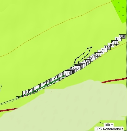
| Abb. 15: Erster Standort. Das
Fahrrad steht dort am Weg, wo das Gebüsch von rechts kommt. Blick in Richtung des Weges von Punkt 186 bis 213. First location. The bicycle stands at the way, where the bushes come from right. View toward the way of point 186 to 213. Punkt 185 10-MAI-09 8:45:25 N51 49 21.7 E10 21 08.5 575 m (FB) |
 |
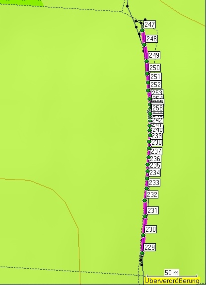
| Abb. 16: Zweiter Standort,
Blick nach Norden in Richtung Punkt 247. Second location, view northward toward point 247 246 10-MAI-09 9:17:35 N51 49 33.1 E10 20 17.6 581 m (FB) |
 |
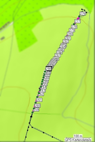
| Abb. 17: Dritter Standort, Blick
nach Norden, von Punkt 259 nach 275. Das Fahrrad steht oben, am Ende der Straße Third location, view northward from point 259 to 275 The bycicle stands above, at the end of the road. (FB) |
 |
| Abb. 18: Erster Standort, first
location (FB) |
 |
| Abb. 19: zweiter Standort, second location
(FB) |
 |
| Abb. 20: Dritter Standort, im
nördlichen Teil fällt das Gelände nach Norden ab. Third location, in the north the area drops down northward. (FB) |
 |
||||||||||||||||||||||||||||||||||||||||||||||||||||||||||||||||||||||||||||||||||||||||||||||||||||||||||||||||||||||||||||||||||||||||||||||||||||||||||||||||||||||||||||||||||||||||||||||||||||||||||||||||||||||||||||||||||||||||||||||||||||||||||||||||||||||||||||||||||||||||||||||||||||||||||||||||||||||||||||||||||||||||||||||||||||||||||||||||||||||||||||||||||||||||||||||||||||||||||||||||||||||||||||||||||||||||||||||||||||||||||||||||||||||||||||||||||||||||||||||||||||||||||||||||||||||||||||||||||||||||||||||||||||||||||||||||||||||||||||||||||||||||||||||||||||||||||||||||||||||||||||||||||||||||||||||||||||||||||||||||||||||||||||||||||||||||||||||||||||||||||||||||||||||||||||||||||||||||||||||||||||||||||||||||||||||||||||||||||||||||||||||||||||||||||||||||||||||||||||||||||||||||||||||||||||||||||||||||||||||||||||||||||||||||||||||||||||||||||||||||||||||||||||||||||||||||||||||||||||||||||||||||||||||||||||||||||||||||
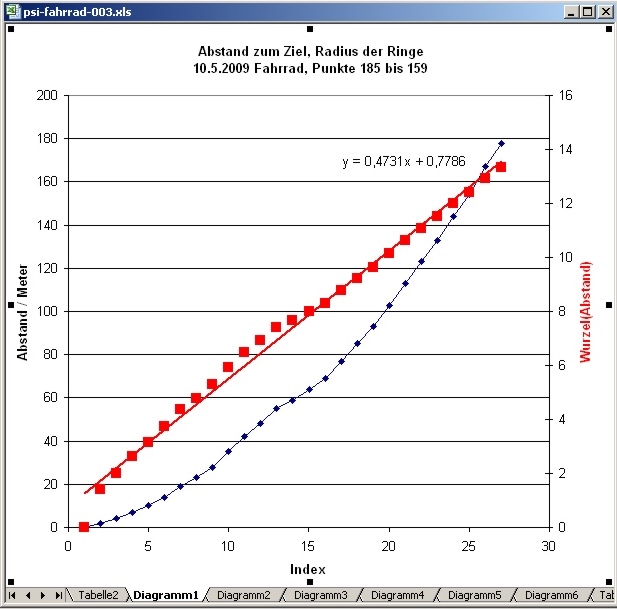
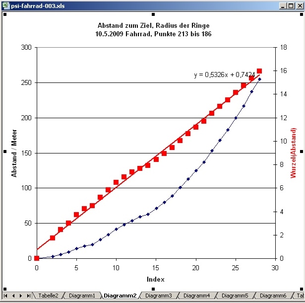
| Abb. 21: Erster Standort,
Richtung 1, Punkte 185 bis 159 Steigung der Gerade: 0,47 Wurzel(Meter) Etwa bei Index 14 scheint eine Unstimmigkeit in der Zählung vorzuliegen, ein seitlicher Versatz von etwa zwei. Die Anfangssteigung der Geraden ist also größer als die hier über alle Punkte gemittelte. First location, direction 1, points 185 to 159 gradient of the straight line: 0.47 root (meter) In the near of index 14 a discrepancy in the counting seems to be present, a lateral disalignment of approximately two. The initial gradient of the line is thus larger than averaged over all points. (FB) |
||||||||||||||||||||||||||||||||||||||||||||||||||||||||||||||||||||||||||||||||||||||||||||||||||||||||||||||||||||||||||||||||||||||||||||||||||||||||||||||||||||||||||||||||||||||||||||||||||||||||||||||||||||||||||||||||||||||||||||||||||||||||||||||||||||||||||||||||||||||||||||||||||||||||||||||||||||||||||||||||||||||||||||||||||||||||||||||||||||||||||||||||||||||||||||||||||||||||||||||||||||||||||||||||||||||||||||||||||||||||||||||||||||||||||||||||||||||||||||||||||||||||||||||||||||||||||||||||||||||||||||||||||||||||||||||||||||||||||||||||||||||||||||||||||||||||||||||||||||||||||||||||||||||||||||||||||||||||||||||||||||||||||||||||||||||||||||||||||||||||||||||||||||||||||||||||||||||||||||||||||||||||||||||||||||||||||||||||||||||||||||||||||||||||||||||||||||||||||||||||||||||||||||||||||||||||||||||||||||||||||||||||||||||||||||||||||||||||||||||||||||||||||||||||||||||||||||||||||||||||||||||||||||||||||||||||||||||||
 |
||||||||||||||||||||||||||||||||||||||||||||||||||||||||||||||||||||||||||||||||||||||||||||||||||||||||||||||||||||||||||||||||||||||||||||||||||||||||||||||||||||||||||||||||||||||||||||||||||||||||||||||||||||||||||||||||||||||||||||||||||||||||||||||||||||||||||||||||||||||||||||||||||||||||||||||||||||||||||||||||||||||||||||||||||||||||||||||||||||||||||||||||||||||||||||||||||||||||||||||||||||||||||||||||||||||||||||||||||||||||||||||||||||||||||||||||||||||||||||||||||||||||||||||||||||||||||||||||||||||||||||||||||||||||||||||||||||||||||||||||||||||||||||||||||||||||||||||||||||||||||||||||||||||||||||||||||||||||||||||||||||||||||||||||||||||||||||||||||||||||||||||||||||||||||||||||||||||||||||||||||||||||||||||||||||||||||||||||||||||||||||||||||||||||||||||||||||||||||||||||||||||||||||||||||||||||||||||||||||||||||||||||||||||||||||||||||||||||||||||||||||||||||||||||||||||||||||||||||||||||||||||||||||||||||||||||||||||||
| Abb. 22: Erster Standort,
Richtung 2, Punkte 213 bis 186 Steigung der Gerade: 0,53 Wurzel(Meter) Auch in diesem Diagramm gibt es einen seitlichen Versatz etwa beim Index 13. Somit wird die Steigung der Gerade im linken Teil etwas größer sein. First location, direction 2, points 213 to 186 gradient of the straight line: 0.53 root (meter) Also in this diagram there is a lateral disalignment for instance at the index 13. Thus the gradient in the left part will be somewhat larger. (FB) |
||||||||||||||||||||||||||||||||||||||||||||||||||||||||||||||||||||||||||||||||||||||||||||||||||||||||||||||||||||||||||||||||||||||||||||||||||||||||||||||||||||||||||||||||||||||||||||||||||||||||||||||||||||||||||||||||||||||||||||||||||||||||||||||||||||||||||||||||||||||||||||||||||||||||||||||||||||||||||||||||||||||||||||||||||||||||||||||||||||||||||||||||||||||||||||||||||||||||||||||||||||||||||||||||||||||||||||||||||||||||||||||||||||||||||||||||||||||||||||||||||||||||||||||||||||||||||||||||||||||||||||||||||||||||||||||||||||||||||||||||||||||||||||||||||||||||||||||||||||||||||||||||||||||||||||||||||||||||||||||||||||||||||||||||||||||||||||||||||||||||||||||||||||||||||||||||||||||||||||||||||||||||||||||||||||||||||||||||||||||||||||||||||||||||||||||||||||||||||||||||||||||||||||||||||||||||||||||||||||||||||||||||||||||||||||||||||||||||||||||||||||||||||||||||||||||||||||||||||||||||||||||||||||||||||||||||||||||||
 |
||||||||||||||||||||||||||||||||||||||||||||||||||||||||||||||||||||||||||||||||||||||||||||||||||||||||||||||||||||||||||||||||||||||||||||||||||||||||||||||||||||||||||||||||||||||||||||||||||||||||||||||||||||||||||||||||||||||||||||||||||||||||||||||||||||||||||||||||||||||||||||||||||||||||||||||||||||||||||||||||||||||||||||||||||||||||||||||||||||||||||||||||||||||||||||||||||||||||||||||||||||||||||||||||||||||||||||||||||||||||||||||||||||||||||||||||||||||||||||||||||||||||||||||||||||||||||||||||||||||||||||||||||||||||||||||||||||||||||||||||||||||||||||||||||||||||||||||||||||||||||||||||||||||||||||||||||||||||||||||||||||||||||||||||||||||||||||||||||||||||||||||||||||||||||||||||||||||||||||||||||||||||||||||||||||||||||||||||||||||||||||||||||||||||||||||||||||||||||||||||||||||||||||||||||||||||||||||||||||||||||||||||||||||||||||||||||||||||||||||||||||||||||||||||||||||||||||||||||||||||||||||||||||||||||||||||||||||||
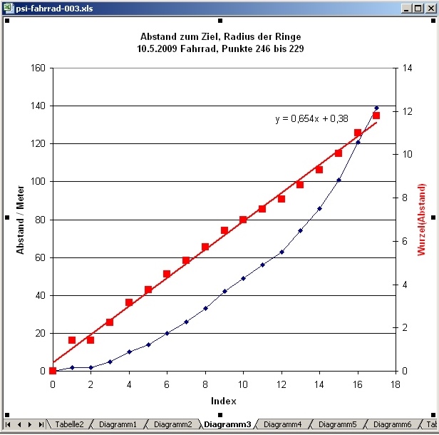
| Abb. 23: Zweiter Standort,
Richtung 1, Punkte 246 bis 229 Steigung der Gerade: 0,65 Wurzel(Meter) Second location, direction 1, points 246 to 229 gradient of the straight line: 0.65 root (meter) (FB) |
||||||||||||||||||||||||||||||||||||||||||||||||||||||||||||||||||||||||||||||||||||||||||||||||||||||||||||||||||||||||||||||||||||||||||||||||||||||||||||||||||||||||||||||||||||||||||||||||||||||||||||||||||||||||||||||||||||||||||||||||||||||||||||||||||||||||||||||||||||||||||||||||||||||||||||||||||||||||||||||||||||||||||||||||||||||||||||||||||||||||||||||||||||||||||||||||||||||||||||||||||||||||||||||||||||||||||||||||||||||||||||||||||||||||||||||||||||||||||||||||||||||||||||||||||||||||||||||||||||||||||||||||||||||||||||||||||||||||||||||||||||||||||||||||||||||||||||||||||||||||||||||||||||||||||||||||||||||||||||||||||||||||||||||||||||||||||||||||||||||||||||||||||||||||||||||||||||||||||||||||||||||||||||||||||||||||||||||||||||||||||||||||||||||||||||||||||||||||||||||||||||||||||||||||||||||||||||||||||||||||||||||||||||||||||||||||||||||||||||||||||||||||||||||||||||||||||||||||||||||||||||||||||||||||||||||||||||||||
 |
||||||||||||||||||||||||||||||||||||||||||||||||||||||||||||||||||||||||||||||||||||||||||||||||||||||||||||||||||||||||||||||||||||||||||||||||||||||||||||||||||||||||||||||||||||||||||||||||||||||||||||||||||||||||||||||||||||||||||||||||||||||||||||||||||||||||||||||||||||||||||||||||||||||||||||||||||||||||||||||||||||||||||||||||||||||||||||||||||||||||||||||||||||||||||||||||||||||||||||||||||||||||||||||||||||||||||||||||||||||||||||||||||||||||||||||||||||||||||||||||||||||||||||||||||||||||||||||||||||||||||||||||||||||||||||||||||||||||||||||||||||||||||||||||||||||||||||||||||||||||||||||||||||||||||||||||||||||||||||||||||||||||||||||||||||||||||||||||||||||||||||||||||||||||||||||||||||||||||||||||||||||||||||||||||||||||||||||||||||||||||||||||||||||||||||||||||||||||||||||||||||||||||||||||||||||||||||||||||||||||||||||||||||||||||||||||||||||||||||||||||||||||||||||||||||||||||||||||||||||||||||||||||||||||||||||||||||||||
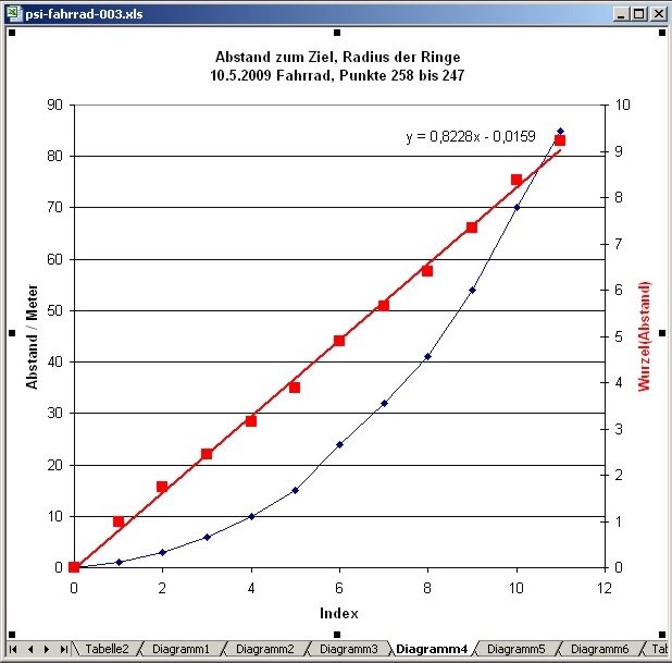
| Abb. 24: Zweiter Standort,
Richtung 2, Punkte 258 bis 247 Steigung der Gerade: 0,82 Wurzel(Meter) Second location, direction 2, points 258 to 247 gradient of the straight line: 0.82 root (meter) (FB) |
||||||||||||||||||||||||||||||||||||||||||||||||||||||||||||||||||||||||||||||||||||||||||||||||||||||||||||||||||||||||||||||||||||||||||||||||||||||||||||||||||||||||||||||||||||||||||||||||||||||||||||||||||||||||||||||||||||||||||||||||||||||||||||||||||||||||||||||||||||||||||||||||||||||||||||||||||||||||||||||||||||||||||||||||||||||||||||||||||||||||||||||||||||||||||||||||||||||||||||||||||||||||||||||||||||||||||||||||||||||||||||||||||||||||||||||||||||||||||||||||||||||||||||||||||||||||||||||||||||||||||||||||||||||||||||||||||||||||||||||||||||||||||||||||||||||||||||||||||||||||||||||||||||||||||||||||||||||||||||||||||||||||||||||||||||||||||||||||||||||||||||||||||||||||||||||||||||||||||||||||||||||||||||||||||||||||||||||||||||||||||||||||||||||||||||||||||||||||||||||||||||||||||||||||||||||||||||||||||||||||||||||||||||||||||||||||||||||||||||||||||||||||||||||||||||||||||||||||||||||||||||||||||||||||||||||||||||||||
 |
||||||||||||||||||||||||||||||||||||||||||||||||||||||||||||||||||||||||||||||||||||||||||||||||||||||||||||||||||||||||||||||||||||||||||||||||||||||||||||||||||||||||||||||||||||||||||||||||||||||||||||||||||||||||||||||||||||||||||||||||||||||||||||||||||||||||||||||||||||||||||||||||||||||||||||||||||||||||||||||||||||||||||||||||||||||||||||||||||||||||||||||||||||||||||||||||||||||||||||||||||||||||||||||||||||||||||||||||||||||||||||||||||||||||||||||||||||||||||||||||||||||||||||||||||||||||||||||||||||||||||||||||||||||||||||||||||||||||||||||||||||||||||||||||||||||||||||||||||||||||||||||||||||||||||||||||||||||||||||||||||||||||||||||||||||||||||||||||||||||||||||||||||||||||||||||||||||||||||||||||||||||||||||||||||||||||||||||||||||||||||||||||||||||||||||||||||||||||||||||||||||||||||||||||||||||||||||||||||||||||||||||||||||||||||||||||||||||||||||||||||||||||||||||||||||||||||||||||||||||||||||||||||||||||||||||||||||||||
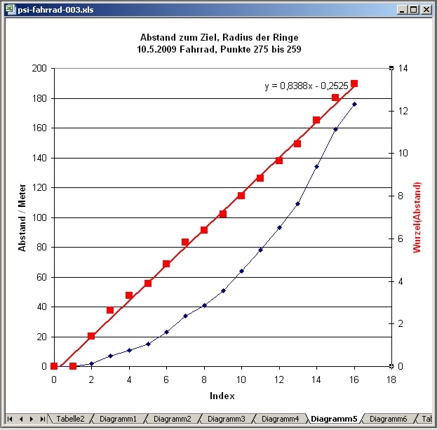
| Abb. 25: Dritter Standort,
Richtung 1, Punkte 275 bis 259 Steigung der Gerade: 0,84 Wurzel(Meter) Third location, direction 1, points 275 to 259 gradient of the straight line: 0.84 root (meter) (FB) |
||||||||||||||||||||||||||||||||||||||||||||||||||||||||||||||||||||||||||||||||||||||||||||||||||||||||||||||||||||||||||||||||||||||||||||||||||||||||||||||||||||||||||||||||||||||||||||||||||||||||||||||||||||||||||||||||||||||||||||||||||||||||||||||||||||||||||||||||||||||||||||||||||||||||||||||||||||||||||||||||||||||||||||||||||||||||||||||||||||||||||||||||||||||||||||||||||||||||||||||||||||||||||||||||||||||||||||||||||||||||||||||||||||||||||||||||||||||||||||||||||||||||||||||||||||||||||||||||||||||||||||||||||||||||||||||||||||||||||||||||||||||||||||||||||||||||||||||||||||||||||||||||||||||||||||||||||||||||||||||||||||||||||||||||||||||||||||||||||||||||||||||||||||||||||||||||||||||||||||||||||||||||||||||||||||||||||||||||||||||||||||||||||||||||||||||||||||||||||||||||||||||||||||||||||||||||||||||||||||||||||||||||||||||||||||||||||||||||||||||||||||||||||||||||||||||||||||||||||||||||||||||||||||||||||||||||||||||||
 |
||||||||||||||||||||||||||||||||||||||||||||||||||||||||||||||||||||||||||||||||||||||||||||||||||||||||||||||||||||||||||||||||||||||||||||||||||||||||||||||||||||||||||||||||||||||||||||||||||||||||||||||||||||||||||||||||||||||||||||||||||||||||||||||||||||||||||||||||||||||||||||||||||||||||||||||||||||||||||||||||||||||||||||||||||||||||||||||||||||||||||||||||||||||||||||||||||||||||||||||||||||||||||||||||||||||||||||||||||||||||||||||||||||||||||||||||||||||||||||||||||||||||||||||||||||||||||||||||||||||||||||||||||||||||||||||||||||||||||||||||||||||||||||||||||||||||||||||||||||||||||||||||||||||||||||||||||||||||||||||||||||||||||||||||||||||||||||||||||||||||||||||||||||||||||||||||||||||||||||||||||||||||||||||||||||||||||||||||||||||||||||||||||||||||||||||||||||||||||||||||||||||||||||||||||||||||||||||||||||||||||||||||||||||||||||||||||||||||||||||||||||||||||||||||||||||||||||||||||||||||||||||||||||||||||||||||||||||||
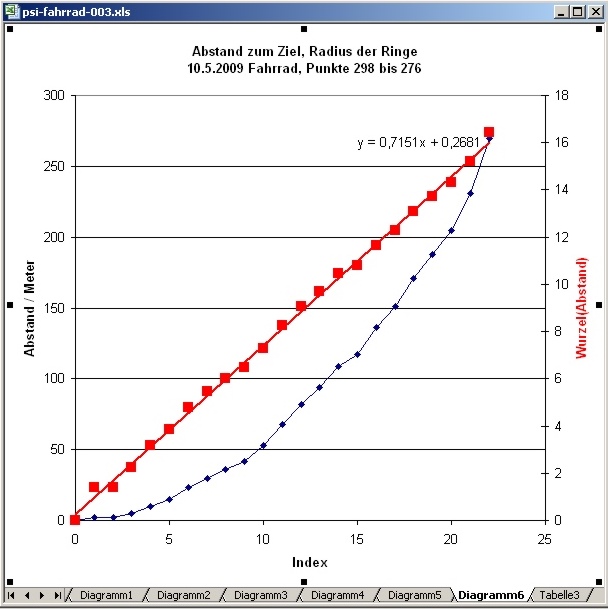
| Abb. 26: Dritter Standort,
Richtung 2, Punkte 298 bis 276, Steigung der Gerade: 0,72 Wurzel(Meter) Third location, direction 2, points 298 to 276, gradient of the straight line: 0.72 root (meter) (FB) |
||||||||||||||||||||||||||||||||||||||||||||||||||||||||||||||||||||||||||||||||||||||||||||||||||||||||||||||||||||||||||||||||||||||||||||||||||||||||||||||||||||||||||||||||||||||||||||||||||||||||||||||||||||||||||||||||||||||||||||||||||||||||||||||||||||||||||||||||||||||||||||||||||||||||||||||||||||||||||||||||||||||||||||||||||||||||||||||||||||||||||||||||||||||||||||||||||||||||||||||||||||||||||||||||||||||||||||||||||||||||||||||||||||||||||||||||||||||||||||||||||||||||||||||||||||||||||||||||||||||||||||||||||||||||||||||||||||||||||||||||||||||||||||||||||||||||||||||||||||||||||||||||||||||||||||||||||||||||||||||||||||||||||||||||||||||||||||||||||||||||||||||||||||||||||||||||||||||||||||||||||||||||||||||||||||||||||||||||||||||||||||||||||||||||||||||||||||||||||||||||||||||||||||||||||||||||||||||||||||||||||||||||||||||||||||||||||||||||||||||||||||||||||||||||||||||||||||||||||||||||||||||||||||||||||||||||||||||||
| Tabelle der mit GPS
protokollierten Punkte im Gelände geologie-001 Name Datum Zeit Koordinate Höhe nach Luftdruckmessung Teil 1 159 10-MAI-09 8:42:15 N51 49 19.1 E10 21 00.2 570 m 160 10-MAI-09 8:42:25 N51 49 19.2 E10 21 00.8 571 m 161 10-MAI-09 8:42:36 N51 49 19.3 E10 21 01.4 572 m 162 10-MAI-09 8:42:45 N51 49 19.5 E10 21 01.9 572 m 163 10-MAI-09 8:42:54 N51 49 19.6 E10 21 02.4 573 m 164 10-MAI-09 8:43:02 N51 49 19.8 E10 21 02.9 573 m 165 10-MAI-09 8:43:10 N51 49 19.9 E10 21 03.4 573 m 166 10-MAI-09 8:43:20 N51 49 20.1 E10 21 03.8 574 m 167 10-MAI-09 8:43:29 N51 49 20.2 E10 21 04.3 574 m 168 10-MAI-09 8:43:37 N51 49 20.3 E10 21 04.7 574 m 169 10-MAI-09 8:43:44 N51 49 20.4 E10 21 05.0 575 m 170 10-MAI-09 8:43:52 N51 49 20.6 E10 21 05.4 574 m 171 10-MAI-09 8:43:58 N51 49 20.6 E10 21 05.6 575 m 172 10-MAI-09 8:44:03 N51 49 20.7 E10 21 05.9 575 m 173 10-MAI-09 8:44:10 N51 49 20.8 E10 21 06.0 575 m 174 10-MAI-09 8:44:17 N51 49 20.9 E10 21 06.4 575 m 175 10-MAI-09 8:44:24 N51 49 21.0 E10 21 06.7 575 m 176 10-MAI-09 8:44:31 N51 49 21.1 E10 21 06.9 575 m 177 10-MAI-09 8:44:40 N51 49 21.2 E10 21 07.3 576 m 178 10-MAI-09 8:44:47 N51 49 21.3 E10 21 07.5 576 m 179 10-MAI-09 8:44:52 N51 49 21.3 E10 21 07.7 575 m 180 10-MAI-09 8:44:58 N51 49 21.4 E10 21 07.9 576 m 181 10-MAI-09 8:45:04 N51 49 21.4 E10 21 08.1 576 m 182 10-MAI-09 8:45:09 N51 49 21.5 E10 21 08.2 575 m 183 10-MAI-09 8:45:15 N51 49 21.5 E10 21 08.4 575 m 184 10-MAI-09 8:45:19 N51 49 21.6 E10 21 08.5 576 m 185 10-MAI-09 8:45:25 N51 49 21.7 E10 21 08.5 575 m Teil 2 186 10-MAI-09 8:50:08 N51 49 26.1 E10 21 19.6 579 m 187 10-MAI-09 8:50:23 N51 49 25.8 E10 21 18.9 580 m 188 10-MAI-09 8:50:40 N51 49 25.4 E10 21 18.1 580 m 189 10-MAI-09 8:50:56 N51 49 25.1 E10 21 17.4 581 m 190 10-MAI-09 8:51:12 N51 49 24.8 E10 21 16.6 581 m 191 10-MAI-09 8:51:26 N51 49 24.5 E10 21 16.0 581 m 192 10-MAI-09 8:51:39 N51 49 24.2 E10 21 15.3 581 m 193 10-MAI-09 8:51:51 N51 49 23.9 E10 21 14.7 582 m 194 10-MAI-09 8:52:03 N51 49 23.7 E10 21 14.2 582 m 195 10-MAI-09 8:52:14 N51 49 23.5 E10 21 13.6 582 m 196 10-MAI-09 8:52:26 N51 49 23.3 E10 21 13.1 582 m 197 10-MAI-09 8:52:37 N51 49 23.0 E10 21 12.6 582 m 198 10-MAI-09 8:52:46 N51 49 22.9 E10 21 12.2 582 m 199 10-MAI-09 8:52:56 N51 49 22.7 E10 21 11.8 583 m 200 10-MAI-09 8:53:05 N51 49 22.6 E10 21 11.5 583 m 201 10-MAI-09 8:53:13 N51 49 22.5 E10 21 11.3 583 m 202 10-MAI-09 8:53:21 N51 49 22.4 E10 21 11.0 583 m 203 10-MAI-09 8:53:29 N51 49 22.3 E10 21 10.8 583 m 204 10-MAI-09 8:53:38 N51 49 22.2 E10 21 10.5 583 m 205 10-MAI-09 8:53:46 N51 49 22.1 E10 21 10.2 583 m 206 10-MAI-09 8:53:54 N51 49 22.0 E10 21 09.8 583 m 207 10-MAI-09 8:54:07 N51 49 21.9 E10 21 09.5 583 m 208 10-MAI-09 8:54:13 N51 49 21.8 E10 21 09.4 583 m 209 10-MAI-09 8:54:21 N51 49 21.8 E10 21 09.2 583 m 210 10-MAI-09 8:54:27 N51 49 21.7 E10 21 09.0 583 m 211 10-MAI-09 8:54:31 N51 49 21.7 E10 21 08.9 583 m 212 10-MAI-09 8:54:37 N51 49 21.6 E10 21 08.7 583 m 213 10-MAI-09 8:54:42 N51 49 21.6 E10 21 08.6 583 m Teil 3 229 10-MAI-09 9:14:56 N51 49 28.6 E10 20 17.2 578 m 230 10-MAI-09 9:15:13 N51 49 29.2 E10 20 17.3 579 m 231 10-MAI-09 9:15:34 N51 49 29.8 E10 20 17.4 582 m 232 10-MAI-09 9:15:49 N51 49 30.3 E10 20 17.4 582 m 233 10-MAI-09 9:15:59 N51 49 30.7 E10 20 17.5 582 m 234 10-MAI-09 9:16:10 N51 49 31.0 E10 20 17.5 582 m 235 10-MAI-09 9:16:18 N51 49 31.3 E10 20 17.5 581 m 236 10-MAI-09 9:16:28 N51 49 31.5 E10 20 17.5 582 m 237 10-MAI-09 9:16:36 N51 49 31.7 E10 20 17.6 581 m 238 10-MAI-09 9:16:48 N51 49 32.0 E10 20 17.6 582 m 239 10-MAI-09 9:16:56 N51 49 32.2 E10 20 17.6 582 m 240 10-MAI-09 9:17:03 N51 49 32.5 E10 20 17.6 581 m 241 10-MAI-09 9:17:10 N51 49 32.6 E10 20 17.6 581 m 242 10-MAI-09 9:17:16 N51 49 32.8 E10 20 17.6 581 m 243 10-MAI-09 9:17:23 N51 49 32.9 E10 20 17.6 581 m 244 10-MAI-09 9:17:28 N51 49 33.0 E10 20 17.6 581 m 245 10-MAI-09 9:17:32 N51 49 33.0 E10 20 17.6 582 m 246 10-MAI-09 9:17:35 N51 49 33.1 E10 20 17.6 581 m Teil 4 247 10-MAI-09 9:20:54 N51 49 35.9 E10 20 17.2 576 m 248 10-MAI-09 9:21:10 N51 49 35.4 E10 20 17.3 577 m 249 10-MAI-09 9:21:29 N51 49 34.9 E10 20 17.5 577 m 250 10-MAI-09 9:21:42 N51 49 34.5 E10 20 17.5 578 m 251 10-MAI-09 9:21:52 N51 49 34.2 E10 20 17.5 579 m 252 10-MAI-09 9:22:01 N51 49 33.9 E10 20 17.5 579 m 253 10-MAI-09 9:22:10 N51 49 33.6 E10 20 17.6 578 m 254 10-MAI-09 9:22:16 N51 49 33.5 E10 20 17.6 578 m 255 10-MAI-09 9:22:22 N51 49 33.3 E10 20 17.7 578 m 256 10-MAI-09 9:22:27 N51 49 33.2 E10 20 17.6 578 m 257 10-MAI-09 9:22:31 N51 49 33.2 E10 20 17.6 578 m 258 10-MAI-09 9:22:36 N51 49 33.2 E10 20 17.6 577 m Teil 5 259 10-MAI-09 9:35:19 N51 49 42.0 E10 20 18.7 561 m 260 10-MAI-09 9:35:36 N51 49 42.6 E10 20 19.0 563 m 261 10-MAI-09 9:35:59 N51 49 43.3 E10 20 19.3 563 m 262 10-MAI-09 9:36:20 N51 49 44.1 E10 20 19.7 563 m 263 10-MAI-09 9:36:37 N51 49 44.6 E10 20 20.0 564 m 264 10-MAI-09 9:36:51 N51 49 45.0 E10 20 20.3 563 m 265 10-MAI-09 9:37:03 N51 49 45.5 E10 20 20.5 564 m 266 10-MAI-09 9:37:16 N51 49 45.9 E10 20 20.7 564 m 267 10-MAI-09 9:37:26 N51 49 46.2 E10 20 20.8 564 m 268 10-MAI-09 9:37:34 N51 49 46.4 E10 20 20.9 564 m 269 10-MAI-09 9:37:44 N51 49 46.7 E10 20 21.1 564 m 270 10-MAI-09 9:37:53 N51 49 47.0 E10 20 21.2 565 m 271 10-MAI-09 9:38:00 N51 49 47.1 E10 20 21.2 565 m 272 10-MAI-09 9:38:05 N51 49 47.2 E10 20 21.3 564 m 273 10-MAI-09 9:38:11 N51 49 47.4 E10 20 21.3 564 m 274 10-MAI-09 9:38:15 N51 49 47.4 E10 20 21.4 564 m 275 10-MAI-09 9:38:20 N51 49 47.5 E10 20 21.4 565 m Teil 6 276 10-MAI-09 9:44:38 N51 49 54.9 E10 20 28.8 552 m 277 10-MAI-09 9:45:15 N51 49 53.9 E10 20 27.6 553 m 278 10-MAI-09 9:45:42 N51 49 53.1 E10 20 26.9 554 m 279 10-MAI-09 9:46:01 N51 49 52.7 E10 20 26.4 556 m 280 10-MAI-09 9:46:17 N51 49 52.2 E10 20 26.0 556 m 281 10-MAI-09 9:46:39 N51 49 51.6 E10 20 25.6 557 m 282 10-MAI-09 9:46:56 N51 49 51.2 E10 20 25.1 557 m 283 10-MAI-09 9:47:16 N51 49 50.7 E10 20 24.7 560 m 284 10-MAI-09 9:47:27 N51 49 50.4 E10 20 24.4 560 m 285 10-MAI-09 9:47:42 N51 49 50.0 E10 20 24.1 560 m 286 10-MAI-09 9:47:57 N51 49 49.7 E10 20 23.7 562 m 287 10-MAI-09 9:48:11 N51 49 49.3 E10 20 23.4 562 m 288 10-MAI-09 9:48:26 N51 49 48.9 E10 20 23.0 563 m 289 10-MAI-09 9:48:41 N51 49 48.6 E10 20 22.6 565 m 290 10-MAI-09 9:48:49 N51 49 48.4 E10 20 22.4 565 m 291 10-MAI-09 9:48:56 N51 49 48.3 E10 20 22.2 564 m 292 10-MAI-09 9:49:07 N51 49 48.1 E10 20 22.0 567 m 293 10-MAI-09 9:49:15 N51 49 47.9 E10 20 21.8 567 m 294 10-MAI-09 9:49:21 N51 49 47.8 E10 20 21.7 567 m 295 10-MAI-09 9:49:29 N51 49 47.6 E10 20 21.5 567 m 296 10-MAI-09 9:49:34 N51 49 47.6 E10 20 21.4 566 m 297 10-MAI-09 9:49:38 N51 49 47.5 E10 20 21.4 566 m 298 10-MAI-09 9:49:45 N51 49 47.5 E10 20 21.3 567 m |
||||||||||||||||||||||||||||||||||||||||||||||||||||||||||||||||||||||||||||||||||||||||||||||||||||||||||||||||||||||||||||||||||||||||||||||||||||||||||||||||||||||||||||||||||||||||||||||||||||||||||||||||||||||||||||||||||||||||||||||||||||||||||||||||||||||||||||||||||||||||||||||||||||||||||||||||||||||||||||||||||||||||||||||||||||||||||||||||||||||||||||||||||||||||||||||||||||||||||||||||||||||||||||||||||||||||||||||||||||||||||||||||||||||||||||||||||||||||||||||||||||||||||||||||||||||||||||||||||||||||||||||||||||||||||||||||||||||||||||||||||||||||||||||||||||||||||||||||||||||||||||||||||||||||||||||||||||||||||||||||||||||||||||||||||||||||||||||||||||||||||||||||||||||||||||||||||||||||||||||||||||||||||||||||||||||||||||||||||||||||||||||||||||||||||||||||||||||||||||||||||||||||||||||||||||||||||||||||||||||||||||||||||||||||||||||||||||||||||||||||||||||||||||||||||||||||||||||||||||||||||||||||||||||||||||||||||||||||
|
||||||||||||||||||||||||||||||||||||||||||||||||||||||||||||||||||||||||||||||||||||||||||||||||||||||||||||||||||||||||||||||||||||||||||||||||||||||||||||||||||||||||||||||||||||||||||||||||||||||||||||||||||||||||||||||||||||||||||||||||||||||||||||||||||||||||||||||||||||||||||||||||||||||||||||||||||||||||||||||||||||||||||||||||||||||||||||||||||||||||||||||||||||||||||||||||||||||||||||||||||||||||||||||||||||||||||||||||||||||||||||||||||||||||||||||||||||||||||||||||||||||||||||||||||||||||||||||||||||||||||||||||||||||||||||||||||||||||||||||||||||||||||||||||||||||||||||||||||||||||||||||||||||||||||||||||||||||||||||||||||||||||||||||||||||||||||||||||||||||||||||||||||||||||||||||||||||||||||||||||||||||||||||||||||||||||||||||||||||||||||||||||||||||||||||||||||||||||||||||||||||||||||||||||||||||||||||||||||||||||||||||||||||||||||||||||||||||||||||||||||||||||||||||||||||||||||||||||||||||||||||||||||||||||||||||||||||||||
| Tabelle: Daten
für die Grafiken (FB) |
 |
www.biosensor-physik.de | (c)
10.09.2010 F.Balck |
© BioSensor-Physik 2010 · Impressum