Beobachtungen
Observations:
Psi-Track, Bernstein, Muster mit
Resonanz-Antenne
ermittelt
Amber, pattern
with resonance
antenna determined
Versuchsprotokoll
Logfile,
journalDieses Experiment wurde ohne Vorbereitung spontan nach den Versuchen mit der Wachskerze Abb. 07 in nosode durchgeführt.
Es gab keine Idee, wie ein zu erwartendes Muster aussehen könnte. Die Strategie entwickelte sich erst aus der Neugier und den ersten Beobachtungen im Laufe des Versuches.
This experiment was performed spontaneously without preparation after the experiments with the wax candle Fig. 07 in nosode .
There was no idea what an expected pattern might look like. The strategy developed only from curiosity and the first observations in the course of the experiment.
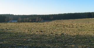
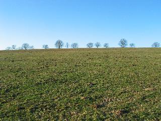
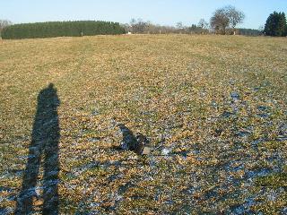
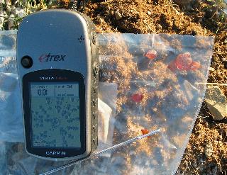
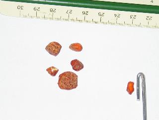
Auf einer leicht abschüssigen Wiese südlich Clausthal-Zellerfelds, bei gutem, aber kalten Wetter, fast windstill, befand sich ein Beutel mit kleinen Krümeln aus Bernstein in einem Mauseloch. geologie-001 kanten-detektor
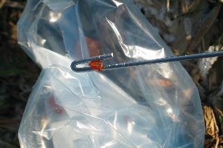
Ein weiteres Stück Bernstein war in die Spitze der L-Rute aus Aluminium geklemmt. nosode
Das "Beugungsmuster" dieser Resonanzanordnung wurde durch den Autor innerhalb einer Zeit von 60 Minuten abgelaufen und mit Hilfe von GPS protokolliert.
Das Ergebnis, in Abb. 09 dargestellt, entspricht etwa dem Muster, wie es in Abb. 01b nosode beschrieben ist.
Ein weiterer Versuch für den Nahbereich wurde auf einer Eisfläche durchgeführt. Bernstein-Eis
O On a slightly sloping meadow south of
Clausthal-Zellerfeld, in good but cold weather, almost
windless, there was a bag with small crumbs of amber in
a mouse hole. geologie-001 kanten-detektor
Another piece of amber was clamped into the tip of the aluminum L-rod. nosode
The "diffraction pattern" of this resonance setup was run by the author within a time of 60 minutes and logged using GPS.
The result, shown in Fig. 09, corresponds approximately to the pattern described in Fig. 01b nosode.
Another close range experiment was conducted on an ice surface. Bernstein-Eis
Strategie
strategyAnother piece of amber was clamped into the tip of the aluminum L-rod. nosode
The "diffraction pattern" of this resonance setup was run by the author within a time of 60 minutes and logged using GPS.
The result, shown in Fig. 09, corresponds approximately to the pattern described in Fig. 01b nosode.
Another close range experiment was conducted on an ice surface. Bernstein-Eis
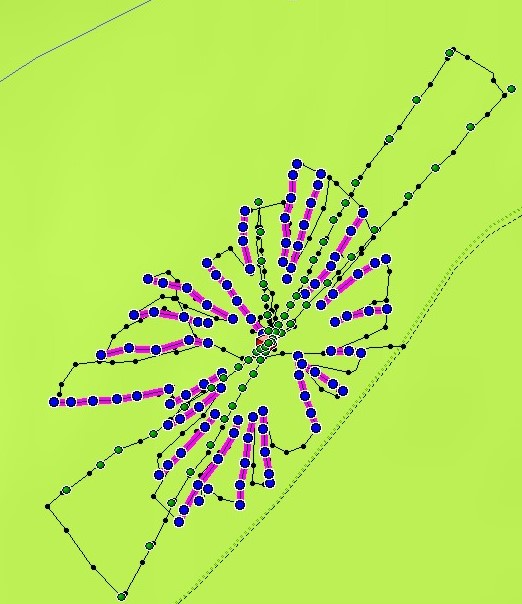
Schritt1: Das Gebiet wurde von außen umrundet. Jeweils wenn eine spürbare Linie etwa in Richtung Mauseloch zu finden war, wurde sie bis zu einer Entfernung von 20 bis 50 Meter zum Ziel verfolgt. Anschließend ging es wieder an den Außenrand zurück.
Abb. 07, schwarze Punkte und Linie (Track)
Step1: The area was circled from the outside.
Whenever a perceptible line could be found, for example
in the direction of the mouse hole, it was followed to a
distance of 20 to 50 meters from the target. Afterwards,
it was returned to the outer edge.
Fig. 07, black dots and line (track)
Schritt2: In fünf Bewegungen in radialer Richtung bis zu
einer
Entfernung von fast 200 Metern ließen sich Elemente der
Kreisstruktur aufzeichnen, davon gingen drei Bewegungen nach
außen und zwei
nach innen auf das Zentrum zu. Abb. 08Fig. 07, black dots and line (track)
Step2: In five movements in radial direction
up to a distance of nearly 200 meters, elements of the
circular structure could be recorded, of which three
movements went outward and two inward toward the center.
Fig. 08
Bei der Überlagerung beider Liniensysteme ließ sich beobachten, daß manche Kreuzungspunkte durch Überlagerung beider Systeme abgeschwächt und andere verstärkt spürbar waren. Dies entspricht der oben erwähnten Darstellung.
Daher war es nicht immer ganz einfach, alle charakteristischen Punkte zu finden, wenn beispielsweise beim tangentialen Gehen gerade ein Kreisabschnitt dazukam, der sich zusammen mit einem radialen Strahl überlagerte und abschwächte.
Gleiches gilt auch für die Ermittlung der Kreispositionen.
When superimposing both line systems, it
could be observed that some crossing points were
attenuated and others were more noticeable by
superimposing both systems. This corresponds to the
representation mentioned above.
Therefore, it was not always easy to find all characteristic points, if, for example, in the case of tangential walking, just a circular section was added, which overlapped and attenuated together with a radial ray.
The same applies to the determination of the circle positions.
Ergebnis
ResultTherefore, it was not always easy to find all characteristic points, if, for example, in the case of tangential walking, just a circular section was added, which overlapped and attenuated together with a radial ray.
The same applies to the determination of the circle positions.
Aus Abb. 09 läßt sich erkennen, daß es prinzipiell möglich sein sollte, eine versteckte Probe zu finden.
Allerdings nicht durch bloßes Daraufzugehen, denn in der Nähe des Zentrums ist die gespürte Situation sehr unübersichtlich.
Eine günstige Strategie könnte sein, sich zunächst optische Peillinien von außen einzurichten, um den Zentrumsbereich zu meiden.
Wenn man dann das Zentrum grob einordnen kann, hilft möglicherweise das Suchen der Kreisringe weiter.
Sofern der Abstand der Kreisringe dabei kleiner wird, kommt man dem Ziel näher.
From Fig. 09 it can be seen that in principle
it should be possible to find a hidden sample.
However, not by just walking towards it, because near the center the sensed situation is very confusing.
A favorable strategy could be to first set up visual bearing lines from the outside to avoid the center area.
If one can then roughly classify the center, possibly the search of the circular rings helps further.
As long as the distance between the circular rings becomes smaller, you will get closer to the target.
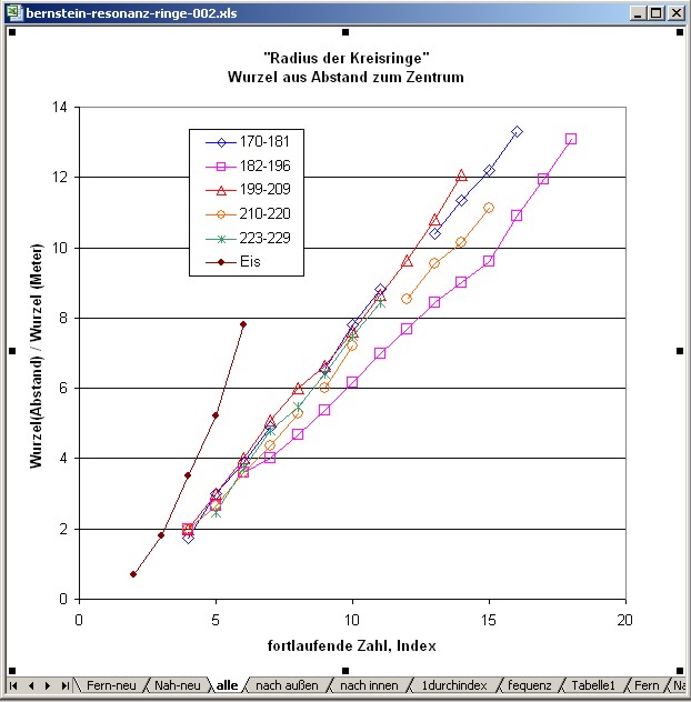
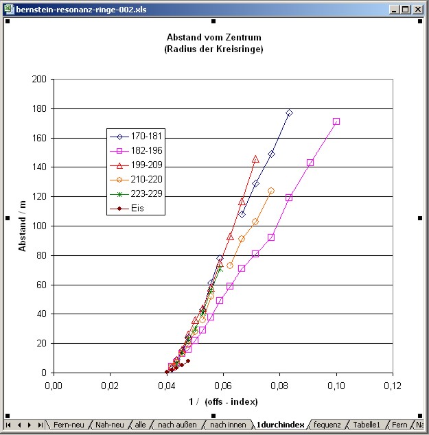
Abstand der Kreisringe Radii of the circles
In der nachfolgenden Tabelle sind die gefundenen Radien zum Zentrum aufgetragen und als Grafik in Abb. 10 und Abb. 11 für den Nahbereich zusammengestellt. Aus der Übersicht in Abb. 09 läßt sich an den farbigen Hilfslinien erkennen, daß es einerseits Übereinstimmung gibt bei den fünf gegangenen Wegen, andererseits aber auch einige Lücken bei der nötigen Punktdichte.
Die gefundenen "Kreisringe" waren verhältnismäßig schmal (weniger als ein Meter breit).
In the following table the found radii to the
center are plotted and compiled as graphics in Fig. 10
and Fig. 11 for the close-up range. From the overview in
fig. 09 it can be recognized at the colored auxiliary
lines that there is on the one hand agreement with the
five gone ways, on the other hand however also some gaps
with the necessary point density.
The found "circular rings" were relatively narrow (less than one meter wide).
The found "circular rings" were relatively narrow (less than one meter wide).
Trotz der Ungenauigkeit der GPS-Daten von einigen Metern und der möglichen Verschiebung der Positionen durch die unterschiedlichen Gehrichtungen lassen die ermittelten Radien übereinstimmend den Schluß zu, daß die Abstände nach außen hin zunehmen.
Despite
the inaccuracy of the GPS data of a few meters and the
possible shift of the positions due to the different
walking directions, the determined radii consistently
allow the conclusion that the distances increase towards
the outside.
zum Verteiler Psi-Track und zu den anderen Psi-Track-Seiten
to the distributor psi-track and to the other psi-track pages psi-track-000
Mathematische Anpassung der Werte Mathematical fit of the values
Eine gute lineare Anpassung erhält man bei der Auftragung der Wurzel aus den Abständen gegen einen fortlaufenden Index.
(Abb. 13)
Somit wären die Abstände proportional zum Quadrat eines fortlaufenden Index.
There
is
a
good linear fitting in
presenting the root of the radii versus a sequential
index.
psi-ringabstand.htm
Handelt es sich um eine symmetrische Anordnung zwischen zwei gleichberechtigten Partnern ???
Does it concern a symmetrical arrangement between two equal partners?
(Bernstein im Mauseloch) <----> (Bernstein an der L-Rute) ?
(amber in the mouse hole) <----> (amber at the L-rod)
Tauschen beide resonant Energie aus? Do both exchange energy resonantly?
Weitere Experimente haben gezeigt, daß sich die beobachteten Effekte vermutlich zu anderen aus dem Gebiet Psi-Track zuordnen lassen.
Further experiments showed that the observed effects can be assigned to the subject psi-track probably.
psi-track-000
Hypothese:
Es scheint sich um eine unsymmetrische Anordnung zu handeln, der Beobachter ist der Sender (und auch Empfänger).
It seems to be an asymmetrical arrangement, the observer is the sender (and also the receiver).
psi-ringabstand.htm
Aber es gibt auch eine andere Interpretation: Aura /Keen 2005/
But there is another interpretation possible: aura
http://maps.live.de/LiveSearch.LocalLive?
interaktives Luftbild mit Google Earth interactive aerial photograph with Google Earth
bernstein-resonanz-002.kmz
Resonanz von zwei Avocados
erweiterte Möglichkeiten des Verfahrens : siehe unter
extended possibilities of the procedure: see under www.resonanzortung.de
 |
 |
| Abb. 01: Auf einer
Wiese
südlich von Clausthal... On a meadow south of Clausthal.. (FB) |
Abb. 02: ... das
Gelände
steigt leicht an. Oben bei den Bäumen verläuft ein Weg. .. the area rises easily. Near the trees there is a way. geologie-001 (FB) |
 |
 |
| Abb. 03: Blick nach
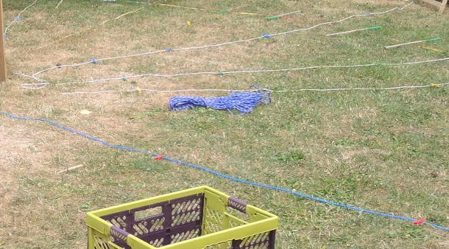
Norden. Neben der Fototasche steckt rechts ein Kunststoffbeutel mit einigen Bernsteinkrümeln in einem Mauseloch. Beside the photo bag is on the right a small plastic bag with some pieces of amber. Original date/time: 2008:12:31 14:29:04 (FB) |
Abb. 04: Der
Kunststoffbeutel,
die L-Rute und das GPS-Gerät The plastic bag, the L-rod and the GPS equipment (FB) |
 |
 |
| Abb. 05: Bernstein im
Beutel und
an der Spitze der L-Rute Amber in the bag and at the tip of the L-rod. (FB) |
Abb. 06: die
Bernsteinkrümel und die Rutenspitze Pieces of amber and the tip of the L-rod (FB) |
 |
|||||||||||||||||||||||||||||||||||||||||||||||||||||||||||||||||||||||||||||||||||||||||||||||||||||||||||||||||||||||||||||||||||||||||||||||||||||||||||||||||||||||||||||||||||||||||||||||||||||||||||||||||||||||||||||||||||||||||||||||||||||||||||||||||||||||||||||||||||||||||||||||||||||||||||||||||||||||||||||||||||||||||||||||||||||||||||||||||||||||||||||||||||||||||||||||||||||||||||||||||||||||||||||||||||||||||||||||||||||||||||||||||||||||||||||||||||||||||||||||||||||||||||||||||||||||||||||||||||||||||||||||||||||||||||||||||||||||||||||||||||||||||||||||||||||||||||||||||||||||||||||||||||||||||||||||||||||||||||||||||||||||||||||||||||||||||||||||||||
| Abb. 07: Radiale
Elemente (lila
und blau) des sternförmigen Musters, mit grün sind die vermuteten Elemente der "Kreisringe" markiert. schwarz beschreibt die abgelaufenen Wege (Track) Radial elements (purple and blue) of the star shaped pattern with green marked elements of the circles. black: walked ways (tracks) (FB) |
|||||||||||||||||||||||||||||||||||||||||||||||||||||||||||||||||||||||||||||||||||||||||||||||||||||||||||||||||||||||||||||||||||||||||||||||||||||||||||||||||||||||||||||||||||||||||||||||||||||||||||||||||||||||||||||||||||||||||||||||||||||||||||||||||||||||||||||||||||||||||||||||||||||||||||||||||||||||||||||||||||||||||||||||||||||||||||||||||||||||||||||||||||||||||||||||||||||||||||||||||||||||||||||||||||||||||||||||||||||||||||||||||||||||||||||||||||||||||||||||||||||||||||||||||||||||||||||||||||||||||||||||||||||||||||||||||||||||||||||||||||||||||||||||||||||||||||||||||||||||||||||||||||||||||||||||||||||||||||||||||||||||||||||||||||||||||||||||||||
 |
|||||||||||||||||||||||||||||||||||||||||||||||||||||||||||||||||||||||||||||||||||||||||||||||||||||||||||||||||||||||||||||||||||||||||||||||||||||||||||||||||||||||||||||||||||||||||||||||||||||||||||||||||||||||||||||||||||||||||||||||||||||||||||||||||||||||||||||||||||||||||||||||||||||||||||||||||||||||||||||||||||||||||||||||||||||||||||||||||||||||||||||||||||||||||||||||||||||||||||||||||||||||||||||||||||||||||||||||||||||||||||||||||||||||||||||||||||||||||||||||||||||||||||||||||||||||||||||||||||||||||||||||||||||||||||||||||||||||||||||||||||||||||||||||||||||||||||||||||||||||||||||||||||||||||||||||||||||||||||||||||||||||||||||||||||||||||||||||||||
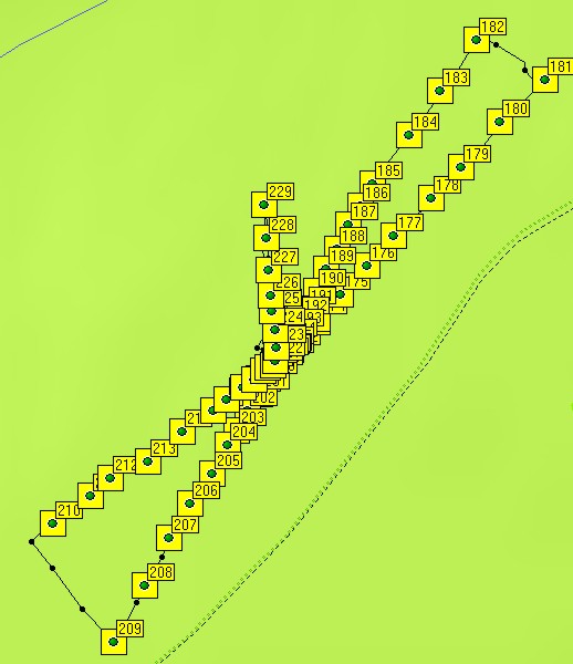
| Abb. 08: Um die
Positionen der
"Kreisringe" aufzunehmen, wurde auf radialen Wege
gegangen (zwischen
den "Strahlen" des Sterns). Die fortlaufende Nummer der markierten Punkte läßt die Laufrichtung erkennen. Punkte 182 bis 196 und 209 bis 220 in Richtung auf das Zentrum zu, die anderen drei Strecken vom Zentrum weg. Abstand zum Zentrum: links unten Punkt 209: 146 Meter, rechts oben Punkt 181: 177 Meter, Gesamtstrecke 146+177 = 323 Meter In order to take the positions of the circles, the ways were gone like the spokes of a wheel. Accordingly to the sequential number of the marked positions the direction of travel can be determined. 182 to 196 and 209 to 220 moving to the center, the others from the center outwards Distance no. 209 to center: 146 meters, no. 181 to center 177 meters, total 323 meters. (FB) |
|||||||||||||||||||||||||||||||||||||||||||||||||||||||||||||||||||||||||||||||||||||||||||||||||||||||||||||||||||||||||||||||||||||||||||||||||||||||||||||||||||||||||||||||||||||||||||||||||||||||||||||||||||||||||||||||||||||||||||||||||||||||||||||||||||||||||||||||||||||||||||||||||||||||||||||||||||||||||||||||||||||||||||||||||||||||||||||||||||||||||||||||||||||||||||||||||||||||||||||||||||||||||||||||||||||||||||||||||||||||||||||||||||||||||||||||||||||||||||||||||||||||||||||||||||||||||||||||||||||||||||||||||||||||||||||||||||||||||||||||||||||||||||||||||||||||||||||||||||||||||||||||||||||||||||||||||||||||||||||||||||||||||||||||||||||||||||||||||||
 |
|||||||||||||||||||||||||||||||||||||||||||||||||||||||||||||||||||||||||||||||||||||||||||||||||||||||||||||||||||||||||||||||||||||||||||||||||||||||||||||||||||||||||||||||||||||||||||||||||||||||||||||||||||||||||||||||||||||||||||||||||||||||||||||||||||||||||||||||||||||||||||||||||||||||||||||||||||||||||||||||||||||||||||||||||||||||||||||||||||||||||||||||||||||||||||||||||||||||||||||||||||||||||||||||||||||||||||||||||||||||||||||||||||||||||||||||||||||||||||||||||||||||||||||||||||||||||||||||||||||||||||||||||||||||||||||||||||||||||||||||||||||||||||||||||||||||||||||||||||||||||||||||||||||||||||||||||||||||||||||||||||||||||||||||||||||||||||||||||||
| Abb. 08a: Das Quadrat hat 150 m
Kantenlänge, weiß: abgelaufene Weg im Zick-Zack: auf spürbaren Linien zum Ziel hin und wieder nach außen. gelb: diese Punkte gehören jeweils zu einer spürbaren Linie. The square has an edge length of 150 m, white: zig-zag path: on perceptible lines towards the target and back out again. Yellow: these points each belong to a perceptible line. (FB) |
|||||||||||||||||||||||||||||||||||||||||||||||||||||||||||||||||||||||||||||||||||||||||||||||||||||||||||||||||||||||||||||||||||||||||||||||||||||||||||||||||||||||||||||||||||||||||||||||||||||||||||||||||||||||||||||||||||||||||||||||||||||||||||||||||||||||||||||||||||||||||||||||||||||||||||||||||||||||||||||||||||||||||||||||||||||||||||||||||||||||||||||||||||||||||||||||||||||||||||||||||||||||||||||||||||||||||||||||||||||||||||||||||||||||||||||||||||||||||||||||||||||||||||||||||||||||||||||||||||||||||||||||||||||||||||||||||||||||||||||||||||||||||||||||||||||||||||||||||||||||||||||||||||||||||||||||||||||||||||||||||||||||||||||||||||||||||||||||||||
 |
|||||||||||||||||||||||||||||||||||||||||||||||||||||||||||||||||||||||||||||||||||||||||||||||||||||||||||||||||||||||||||||||||||||||||||||||||||||||||||||||||||||||||||||||||||||||||||||||||||||||||||||||||||||||||||||||||||||||||||||||||||||||||||||||||||||||||||||||||||||||||||||||||||||||||||||||||||||||||||||||||||||||||||||||||||||||||||||||||||||||||||||||||||||||||||||||||||||||||||||||||||||||||||||||||||||||||||||||||||||||||||||||||||||||||||||||||||||||||||||||||||||||||||||||||||||||||||||||||||||||||||||||||||||||||||||||||||||||||||||||||||||||||||||||||||||||||||||||||||||||||||||||||||||||||||||||||||||||||||||||||||||||||||||||||||||||||||||||||||
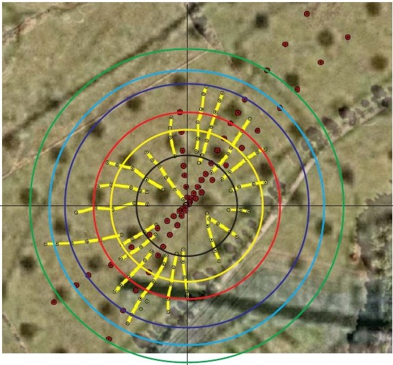
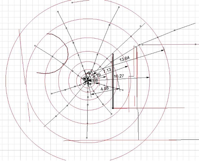
| Abb. 09: radiale
(gelb) und
tangentiale (rot) Elemente des spürbaren Musters. Die farbigen Hilfskreise dienen zur besseren Orientierung. Die Ungenauigkeit der GPS-Daten beträgt mehrere Meter. Radial (yellow) and tangential (red) elements of the pattern. The coloured auxiliary circles serve for better orientation. The inaccuracy of the GPS data amounts to several meters. (Geologische Karte und FB) |
|||||||||||||||||||||||||||||||||||||||||||||||||||||||||||||||||||||||||||||||||||||||||||||||||||||||||||||||||||||||||||||||||||||||||||||||||||||||||||||||||||||||||||||||||||||||||||||||||||||||||||||||||||||||||||||||||||||||||||||||||||||||||||||||||||||||||||||||||||||||||||||||||||||||||||||||||||||||||||||||||||||||||||||||||||||||||||||||||||||||||||||||||||||||||||||||||||||||||||||||||||||||||||||||||||||||||||||||||||||||||||||||||||||||||||||||||||||||||||||||||||||||||||||||||||||||||||||||||||||||||||||||||||||||||||||||||||||||||||||||||||||||||||||||||||||||||||||||||||||||||||||||||||||||||||||||||||||||||||||||||||||||||||||||||||||||||||||||||||
 |
|||||||||||||||||||||||||||||||||||||||||||||||||||||||||||||||||||||||||||||||||||||||||||||||||||||||||||||||||||||||||||||||||||||||||||||||||||||||||||||||||||||||||||||||||||||||||||||||||||||||||||||||||||||||||||||||||||||||||||||||||||||||||||||||||||||||||||||||||||||||||||||||||||||||||||||||||||||||||||||||||||||||||||||||||||||||||||||||||||||||||||||||||||||||||||||||||||||||||||||||||||||||||||||||||||||||||||||||||||||||||||||||||||||||||||||||||||||||||||||||||||||||||||||||||||||||||||||||||||||||||||||||||||||||||||||||||||||||||||||||||||||||||||||||||||||||||||||||||||||||||||||||||||||||||||||||||||||||||||||||||||||||||||||||||||||||||||||||||||
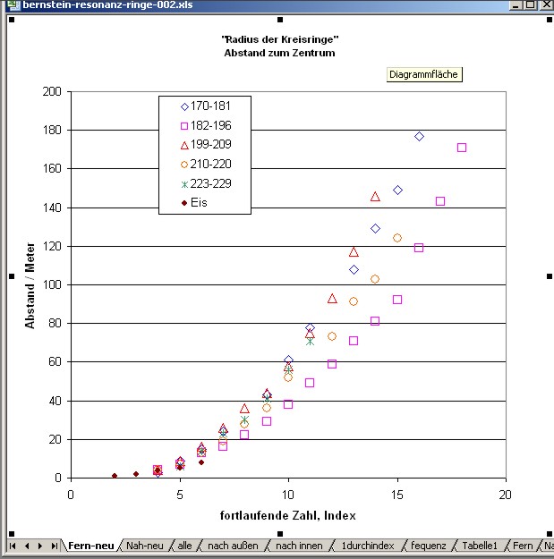
| Abb. 10: Abstand zum
Zentrum der
gespürten Positionen der "Kreisringe", aufgetragen
gegen einen
fortlaufenden Index. An einigen Stellen fehlen
Positionen, der Index
wurde entsprechend erhöht. In der Tabelle als "fehlt" vermerkt. Radii of the circles versus a sequential index. There are some missing positions, but the index was increased accordingly. In the table they are noted as "missing". indizierung (FB) |
|||||||||||||||||||||||||||||||||||||||||||||||||||||||||||||||||||||||||||||||||||||||||||||||||||||||||||||||||||||||||||||||||||||||||||||||||||||||||||||||||||||||||||||||||||||||||||||||||||||||||||||||||||||||||||||||||||||||||||||||||||||||||||||||||||||||||||||||||||||||||||||||||||||||||||||||||||||||||||||||||||||||||||||||||||||||||||||||||||||||||||||||||||||||||||||||||||||||||||||||||||||||||||||||||||||||||||||||||||||||||||||||||||||||||||||||||||||||||||||||||||||||||||||||||||||||||||||||||||||||||||||||||||||||||||||||||||||||||||||||||||||||||||||||||||||||||||||||||||||||||||||||||||||||||||||||||||||||||||||||||||||||||||||||||||||||||||||||||||
 |
|||||||||||||||||||||||||||||||||||||||||||||||||||||||||||||||||||||||||||||||||||||||||||||||||||||||||||||||||||||||||||||||||||||||||||||||||||||||||||||||||||||||||||||||||||||||||||||||||||||||||||||||||||||||||||||||||||||||||||||||||||||||||||||||||||||||||||||||||||||||||||||||||||||||||||||||||||||||||||||||||||||||||||||||||||||||||||||||||||||||||||||||||||||||||||||||||||||||||||||||||||||||||||||||||||||||||||||||||||||||||||||||||||||||||||||||||||||||||||||||||||||||||||||||||||||||||||||||||||||||||||||||||||||||||||||||||||||||||||||||||||||||||||||||||||||||||||||||||||||||||||||||||||||||||||||||||||||||||||||||||||||||||||||||||||||||||||||||||||
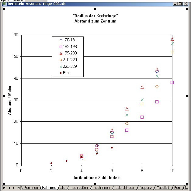
| Abb. 11: Abstand der
Positionen,
im Nahbereich Im linken Teil sind die Ergebnisse der Beobachtung auf der Eisfläche eingetragen. Radii of the circles, at close range. In the left part the observations on the ice surface are registered. Bernstein-Eis (FB) |
|||||||||||||||||||||||||||||||||||||||||||||||||||||||||||||||||||||||||||||||||||||||||||||||||||||||||||||||||||||||||||||||||||||||||||||||||||||||||||||||||||||||||||||||||||||||||||||||||||||||||||||||||||||||||||||||||||||||||||||||||||||||||||||||||||||||||||||||||||||||||||||||||||||||||||||||||||||||||||||||||||||||||||||||||||||||||||||||||||||||||||||||||||||||||||||||||||||||||||||||||||||||||||||||||||||||||||||||||||||||||||||||||||||||||||||||||||||||||||||||||||||||||||||||||||||||||||||||||||||||||||||||||||||||||||||||||||||||||||||||||||||||||||||||||||||||||||||||||||||||||||||||||||||||||||||||||||||||||||||||||||||||||||||||||||||||||||||||||||
 |
|||||||||||||||||||||||||||||||||||||||||||||||||||||||||||||||||||||||||||||||||||||||||||||||||||||||||||||||||||||||||||||||||||||||||||||||||||||||||||||||||||||||||||||||||||||||||||||||||||||||||||||||||||||||||||||||||||||||||||||||||||||||||||||||||||||||||||||||||||||||||||||||||||||||||||||||||||||||||||||||||||||||||||||||||||||||||||||||||||||||||||||||||||||||||||||||||||||||||||||||||||||||||||||||||||||||||||||||||||||||||||||||||||||||||||||||||||||||||||||||||||||||||||||||||||||||||||||||||||||||||||||||||||||||||||||||||||||||||||||||||||||||||||||||||||||||||||||||||||||||||||||||||||||||||||||||||||||||||||||||||||||||||||||||||||||||||||||||||||
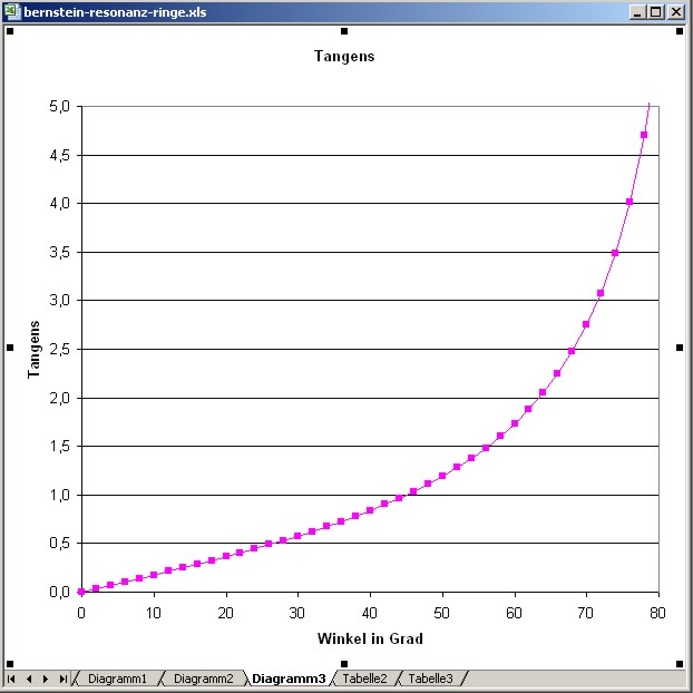
| Abb. 12: Zum
Vergleich die
Funktion Tangens. Mit ihr lassen sich die obigen
Daten jedoch nicht
gut anpassen. For comparison the function tangent. There is no fitting possible with the above data. (FB) |
|||||||||||||||||||||||||||||||||||||||||||||||||||||||||||||||||||||||||||||||||||||||||||||||||||||||||||||||||||||||||||||||||||||||||||||||||||||||||||||||||||||||||||||||||||||||||||||||||||||||||||||||||||||||||||||||||||||||||||||||||||||||||||||||||||||||||||||||||||||||||||||||||||||||||||||||||||||||||||||||||||||||||||||||||||||||||||||||||||||||||||||||||||||||||||||||||||||||||||||||||||||||||||||||||||||||||||||||||||||||||||||||||||||||||||||||||||||||||||||||||||||||||||||||||||||||||||||||||||||||||||||||||||||||||||||||||||||||||||||||||||||||||||||||||||||||||||||||||||||||||||||||||||||||||||||||||||||||||||||||||||||||||||||||||||||||||||||||||||
 |
|||||||||||||||||||||||||||||||||||||||||||||||||||||||||||||||||||||||||||||||||||||||||||||||||||||||||||||||||||||||||||||||||||||||||||||||||||||||||||||||||||||||||||||||||||||||||||||||||||||||||||||||||||||||||||||||||||||||||||||||||||||||||||||||||||||||||||||||||||||||||||||||||||||||||||||||||||||||||||||||||||||||||||||||||||||||||||||||||||||||||||||||||||||||||||||||||||||||||||||||||||||||||||||||||||||||||||||||||||||||||||||||||||||||||||||||||||||||||||||||||||||||||||||||||||||||||||||||||||||||||||||||||||||||||||||||||||||||||||||||||||||||||||||||||||||||||||||||||||||||||||||||||||||||||||||||||||||||||||||||||||||||||||||||||||||||||||||||||||
| Abb. 13: Trägt man
die
Wurzel der Abstände (Radien) auf, dann ergibt sich
nahezu ein
linearer Zusammenhang. Die Daten vom Eis haben
offensichtlich etwas
andere Eigenschaften. Aus diesen "Geraden" läßt sich entnehmen, daß der Radius proportional zum Quadrat vom Index ist. Die benutzte Parameter ioff = 3 wirkt hier als Verschiebung auf der x-Achse. Die Lücken zwischen den Werten stehen für vermutlich nicht gefundene Positionen. If we plot the root of the distances (radii), we get almost a linear relationship. The data from the ice obviously have somewhat different properties. From these "straight lines" it can be seen that the radius is proportional to the square of the index. The used parameter ioff = 3 acts here as a shift on the x-axis. The gaps between the values stand for presumably not found positions. (FB) |
|||||||||||||||||||||||||||||||||||||||||||||||||||||||||||||||||||||||||||||||||||||||||||||||||||||||||||||||||||||||||||||||||||||||||||||||||||||||||||||||||||||||||||||||||||||||||||||||||||||||||||||||||||||||||||||||||||||||||||||||||||||||||||||||||||||||||||||||||||||||||||||||||||||||||||||||||||||||||||||||||||||||||||||||||||||||||||||||||||||||||||||||||||||||||||||||||||||||||||||||||||||||||||||||||||||||||||||||||||||||||||||||||||||||||||||||||||||||||||||||||||||||||||||||||||||||||||||||||||||||||||||||||||||||||||||||||||||||||||||||||||||||||||||||||||||||||||||||||||||||||||||||||||||||||||||||||||||||||||||||||||||||||||||||||||||||||||||||||||
 |
|||||||||||||||||||||||||||||||||||||||||||||||||||||||||||||||||||||||||||||||||||||||||||||||||||||||||||||||||||||||||||||||||||||||||||||||||||||||||||||||||||||||||||||||||||||||||||||||||||||||||||||||||||||||||||||||||||||||||||||||||||||||||||||||||||||||||||||||||||||||||||||||||||||||||||||||||||||||||||||||||||||||||||||||||||||||||||||||||||||||||||||||||||||||||||||||||||||||||||||||||||||||||||||||||||||||||||||||||||||||||||||||||||||||||||||||||||||||||||||||||||||||||||||||||||||||||||||||||||||||||||||||||||||||||||||||||||||||||||||||||||||||||||||||||||||||||||||||||||||||||||||||||||||||||||||||||||||||||||||||||||||||||||||||||||||||||||||||||||
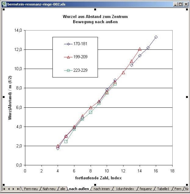
| Abb. 13a: Wurzel aus
den
Abständen, Bewegungsrichtung nach außen. Die Lücken zwischen den Werten stehen für vermutlich nicht gefundene Positionen. Root of the distances, direction of movement outward. The gaps between the values stand for presumably not found positions. . (FB) |
|||||||||||||||||||||||||||||||||||||||||||||||||||||||||||||||||||||||||||||||||||||||||||||||||||||||||||||||||||||||||||||||||||||||||||||||||||||||||||||||||||||||||||||||||||||||||||||||||||||||||||||||||||||||||||||||||||||||||||||||||||||||||||||||||||||||||||||||||||||||||||||||||||||||||||||||||||||||||||||||||||||||||||||||||||||||||||||||||||||||||||||||||||||||||||||||||||||||||||||||||||||||||||||||||||||||||||||||||||||||||||||||||||||||||||||||||||||||||||||||||||||||||||||||||||||||||||||||||||||||||||||||||||||||||||||||||||||||||||||||||||||||||||||||||||||||||||||||||||||||||||||||||||||||||||||||||||||||||||||||||||||||||||||||||||||||||||||||||||
 |
|||||||||||||||||||||||||||||||||||||||||||||||||||||||||||||||||||||||||||||||||||||||||||||||||||||||||||||||||||||||||||||||||||||||||||||||||||||||||||||||||||||||||||||||||||||||||||||||||||||||||||||||||||||||||||||||||||||||||||||||||||||||||||||||||||||||||||||||||||||||||||||||||||||||||||||||||||||||||||||||||||||||||||||||||||||||||||||||||||||||||||||||||||||||||||||||||||||||||||||||||||||||||||||||||||||||||||||||||||||||||||||||||||||||||||||||||||||||||||||||||||||||||||||||||||||||||||||||||||||||||||||||||||||||||||||||||||||||||||||||||||||||||||||||||||||||||||||||||||||||||||||||||||||||||||||||||||||||||||||||||||||||||||||||||||||||||||||||||||
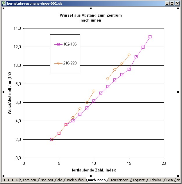
| Abb. 13b: Wurzel aus
den
Abständen, Bewegungsrichtung nach innen. Die Lücken zwischen den Werten stehen für vermutlich nicht gefundene Positionen. Root of the radii, direction of motion inward. (FB) |
|||||||||||||||||||||||||||||||||||||||||||||||||||||||||||||||||||||||||||||||||||||||||||||||||||||||||||||||||||||||||||||||||||||||||||||||||||||||||||||||||||||||||||||||||||||||||||||||||||||||||||||||||||||||||||||||||||||||||||||||||||||||||||||||||||||||||||||||||||||||||||||||||||||||||||||||||||||||||||||||||||||||||||||||||||||||||||||||||||||||||||||||||||||||||||||||||||||||||||||||||||||||||||||||||||||||||||||||||||||||||||||||||||||||||||||||||||||||||||||||||||||||||||||||||||||||||||||||||||||||||||||||||||||||||||||||||||||||||||||||||||||||||||||||||||||||||||||||||||||||||||||||||||||||||||||||||||||||||||||||||||||||||||||||||||||||||||||||||||
 |
|||||||||||||||||||||||||||||||||||||||||||||||||||||||||||||||||||||||||||||||||||||||||||||||||||||||||||||||||||||||||||||||||||||||||||||||||||||||||||||||||||||||||||||||||||||||||||||||||||||||||||||||||||||||||||||||||||||||||||||||||||||||||||||||||||||||||||||||||||||||||||||||||||||||||||||||||||||||||||||||||||||||||||||||||||||||||||||||||||||||||||||||||||||||||||||||||||||||||||||||||||||||||||||||||||||||||||||||||||||||||||||||||||||||||||||||||||||||||||||||||||||||||||||||||||||||||||||||||||||||||||||||||||||||||||||||||||||||||||||||||||||||||||||||||||||||||||||||||||||||||||||||||||||||||||||||||||||||||||||||||||||||||||||||||||||||||||||||||||
| Abb. 14:Versuch zur
Analyse: Annahme: stehende Wellen zwischen Sender und Empfänger Dann müßte der Abstand proportional zum einem "gespiegelten" Index sein, Auftragung Abstand gegen 1 / (Offset2-Index), Versuch mit offset2 = 25, liefert Geraden. für die Werte 199 bis 209 ergibt sich eine Gerade etwa mit der Gleichung y = 4700 x - 200 Da die Geraden aber nicht durch den Ursprung gehen, scheint die Annahme falsch zu sein. Attempt at analysis: Assumption: standing waves between transmitter and receiver Then the distance should be proportional to a "mirrored" index, Plot distance against 1 / (offset2 index), try with offset2 = 25, yields straight lines. for the values 199 to 209 a straight line results approximately with the equation y = 4700 x - 200 But since the straight lines do not go through the origin, the assumption seems to be wrong. . (FB) |
|||||||||||||||||||||||||||||||||||||||||||||||||||||||||||||||||||||||||||||||||||||||||||||||||||||||||||||||||||||||||||||||||||||||||||||||||||||||||||||||||||||||||||||||||||||||||||||||||||||||||||||||||||||||||||||||||||||||||||||||||||||||||||||||||||||||||||||||||||||||||||||||||||||||||||||||||||||||||||||||||||||||||||||||||||||||||||||||||||||||||||||||||||||||||||||||||||||||||||||||||||||||||||||||||||||||||||||||||||||||||||||||||||||||||||||||||||||||||||||||||||||||||||||||||||||||||||||||||||||||||||||||||||||||||||||||||||||||||||||||||||||||||||||||||||||||||||||||||||||||||||||||||||||||||||||||||||||||||||||||||||||||||||||||||||||||||||||||||||
 |
|||||||||||||||||||||||||||||||||||||||||||||||||||||||||||||||||||||||||||||||||||||||||||||||||||||||||||||||||||||||||||||||||||||||||||||||||||||||||||||||||||||||||||||||||||||||||||||||||||||||||||||||||||||||||||||||||||||||||||||||||||||||||||||||||||||||||||||||||||||||||||||||||||||||||||||||||||||||||||||||||||||||||||||||||||||||||||||||||||||||||||||||||||||||||||||||||||||||||||||||||||||||||||||||||||||||||||||||||||||||||||||||||||||||||||||||||||||||||||||||||||||||||||||||||||||||||||||||||||||||||||||||||||||||||||||||||||||||||||||||||||||||||||||||||||||||||||||||||||||||||||||||||||||||||||||||||||||||||||||||||||||||||||||||||||||||||||||||||||
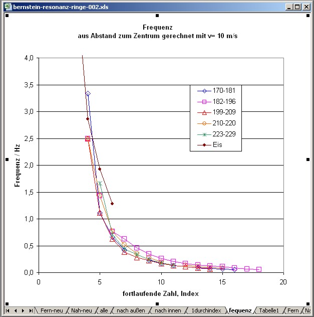
| Abb. 15: Auftragung
einer
"Frequenz" als Geschwindigkeit durch Abstand. Gerechnet wurde für eine Geschwindigkeit von 10 m/s busscher Bei der Annahme von stehenden Wellen zwischen Sender und Empfänger und einer einzigen anregenden Grundfrequenz mit Oberwellen müßte ein konstanter Abstand zwischen den Werten herauskommen. Dies ist nicht der Fall. Plot of a "frequency" (speed divided by distance) for a speed of 10 m/s Hypothesis: Standing waves between sender and receiver and a single basic frequency with harmonics, a constant distance between the radii should result. But this is not the case. (FB) |
|||||||||||||||||||||||||||||||||||||||||||||||||||||||||||||||||||||||||||||||||||||||||||||||||||||||||||||||||||||||||||||||||||||||||||||||||||||||||||||||||||||||||||||||||||||||||||||||||||||||||||||||||||||||||||||||||||||||||||||||||||||||||||||||||||||||||||||||||||||||||||||||||||||||||||||||||||||||||||||||||||||||||||||||||||||||||||||||||||||||||||||||||||||||||||||||||||||||||||||||||||||||||||||||||||||||||||||||||||||||||||||||||||||||||||||||||||||||||||||||||||||||||||||||||||||||||||||||||||||||||||||||||||||||||||||||||||||||||||||||||||||||||||||||||||||||||||||||||||||||||||||||||||||||||||||||||||||||||||||||||||||||||||||||||||||||||||||||||||
Tabelle 1:
Tabelle 01: Aus den gespürten Positionen der "Kreisringe" wurden die Abstände zum Zentrum errechnet und gegen einen fortlaufenden Index aufgetragen. Bei den drei Wegen vom Zentrum weg und den zwei auf das Zentrum zu wurden offensichtlich nicht alle (theoretischen?) Positionen erfaßt. Daher ist die Zuordnung mit einem fortlaufendem Index nicht immer lückenlos möglich. Für die Darstellung wurden bei Bedarf einige Werte übersprungen (als "fehlt" markiert in der Tabelle).
indizierung (FB) |
|||||||||||||||||||||||||||||||||||||||||||||||||||||||||||||||||||||||||||||||||||||||||||||||||||||||||||||||||||||||||||||||||||||||||||||||||||||||||||||||||||||||||||||||||||||||||||||||||||||||||||||||||||||||||||||||||||||||||||||||||||||||||||||||||||||||||||||||||||||||||||||||||||||||||||||||||||||||||||||||||||||||||||||||||||||||||||||||||||||||||||||||||||||||||||||||||||||||||||||||||||||||||||||||||||||||||||||||||||||||||||||||||||||||||||||||||||||||||||||||||||||||||||||||||||||||||||||||||||||||||||||||||||||||||||||||||||||||||||||||||||||||||||||||||||||||||||||||||||||||||||||||||||||||||||||||||||||||||||||||||||||||||||||||||||||||||||||||||||
Tabelle 2: Tabelle der mit GPS protokollierten Punkte im Gelände geologie-001 Dauer: etwa 60 Minuten Name Datum Zeit Koordinate Höhe nach Luftdruckmessung Positionen auf den "Speichen" des Musters 068 31-DEZ-08 13:49:12 N51 47.572 E10 19.440 586 m 069 31-DEZ-08 13:49:28 N51 47.571 E10 19.446 587 m 070 31-DEZ-08 13:49:42 N51 47.570 E10 19.457 588 m 071 31-DEZ-08 13:50:22 N51 47.565 E10 19.466 589 m 072 31-DEZ-08 13:50:38 N51 47.561 E10 19.477 590 m 073 31-DEZ-08 13:51:43 N51 47.563 E10 19.433 587 m 074 31-DEZ-08 13:51:58 N51 47.563 E10 19.442 588 m 075 31-DEZ-08 13:52:14 N51 47.562 E10 19.455 589 m 076 31-DEZ-08 13:52:23 N51 47.561 E10 19.462 589 m 077 31-DEZ-08 13:52:34 N51 47.560 E10 19.466 590 m 078 31-DEZ-08 13:54:12 N51 47.552 E10 19.419 585 m 079 31-DEZ-08 13:54:29 N51 47.554 E10 19.432 588 m 080 31-DEZ-08 13:54:42 N51 47.553 E10 19.443 588 m 081 31-DEZ-08 13:55:02 N51 47.556 E10 19.458 590 m 082 31-DEZ-08 13:55:16 N51 47.555 E10 19.466 590 m 083 31-DEZ-08 13:56:56 N51 47.539 E10 19.399 584 m 084 31-DEZ-08 13:57:09 N51 47.539 E10 19.406 586 m 085 31-DEZ-08 13:57:20 N51 47.539 E10 19.416 586 m 086 31-DEZ-08 13:57:33 N51 47.540 E10 19.426 588 m 087 31-DEZ-08 13:57:45 N51 47.541 E10 19.435 588 m 088 31-DEZ-08 13:58:08 N51 47.543 E10 19.449 590 m 089 31-DEZ-08 13:58:33 N51 47.539 E10 19.449 589 m 090 31-DEZ-08 13:58:48 N51 47.541 E10 19.456 590 m 091 31-DEZ-08 13:59:03 N51 47.544 E10 19.464 592 m 092 31-DEZ-08 13:59:17 N51 47.547 E10 19.472 591 m 093 31-DEZ-08 14:00:05 N51 47.533 E10 19.448 591 m 094 31-DEZ-08 14:00:19 N51 47.535 E10 19.454 590 m 095 31-DEZ-08 14:00:31 N51 47.538 E10 19.462 591 m 096 31-DEZ-08 14:00:45 N51 47.543 E10 19.472 591 m 097 31-DEZ-08 14:01:43 N51 47.519 E10 19.445 592 m 098 31-DEZ-08 14:01:57 N51 47.522 E10 19.448 590 m 099 31-DEZ-08 14:02:09 N51 47.526 E10 19.454 591 m 100 31-DEZ-08 14:02:29 N51 47.532 E10 19.465 591 m 101 31-DEZ-08 14:02:38 N51 47.536 E10 19.469 592 m 102 31-DEZ-08 14:03:54 N51 47.507 E10 19.453 593 m 103 31-DEZ-08 14:04:06 N51 47.510 E10 19.456 593 m 104 31-DEZ-08 14:04:19 N51 47.517 E10 19.462 593 m 105 31-DEZ-08 14:04:37 N51 47.524 E10 19.470 593 m 106 31-DEZ-08 14:04:54 N51 47.531 E10 19.477 593 m 107 31-DEZ-08 14:05:04 N51 47.534 E10 19.479 593 m 108 31-DEZ-08 14:05:53 N51 47.513 E10 19.462 593 m 109 31-DEZ-08 14:06:07 N51 47.516 E10 19.466 593 m 110 31-DEZ-08 14:06:50 N51 47.511 E10 19.480 594 m 111 31-DEZ-08 14:07:03 N51 47.517 E10 19.480 594 m 112 31-DEZ-08 14:07:16 N51 47.523 E10 19.482 594 m 113 31-DEZ-08 14:07:30 N51 47.530 E10 19.484 594 m 114 31-DEZ-08 14:07:41 N51 47.535 E10 19.486 594 m 115 31-DEZ-08 14:08:23 N51 47.517 E10 19.493 594 m 116 31-DEZ-08 14:08:32 N51 47.520 E10 19.492 595 m 117 31-DEZ-08 14:08:44 N51 47.526 E10 19.491 595 m 118 31-DEZ-08 14:08:58 N51 47.532 E10 19.490 595 m 119 31-DEZ-08 14:09:08 N51 47.537 E10 19.490 594 m 120 31-DEZ-08 14:09:56 N51 47.532 E10 19.513 596 m 121 31-DEZ-08 14:10:08 N51 47.536 E10 19.511 596 m 122 31-DEZ-08 14:10:19 N51 47.541 E10 19.508 596 m 123 31-DEZ-08 14:10:32 N51 47.547 E10 19.506 595 m 124 31-DEZ-08 14:10:47 N51 47.552 E10 19.505 595 m 125 31-DEZ-08 14:11:35 N51 47.542 E10 19.525 596 m 126 31-DEZ-08 14:11:49 N51 47.544 E10 19.520 596 m 127 31-DEZ-08 14:12:00 N51 47.547 E10 19.512 595 m 128 31-DEZ-08 14:12:09 N51 47.549 E10 19.507 595 m 129 31-DEZ-08 14:12:45 N51 47.552 E10 19.533 596 m 130 31-DEZ-08 14:12:56 N51 47.553 E10 19.527 596 m 131 31-DEZ-08 14:13:05 N51 47.553 E10 19.519 595 m 132 31-DEZ-08 14:13:48 N51 47.564 E10 19.544 595 m 133 31-DEZ-08 14:14:05 N51 47.564 E10 19.536 594 m 134 31-DEZ-08 14:14:20 N51 47.562 E10 19.526 594 m 135 31-DEZ-08 14:14:27 N51 47.561 E10 19.521 594 m 136 31-DEZ-08 14:15:19 N51 47.578 E10 19.544 596 m 137 31-DEZ-08 14:15:31 N51 47.577 E10 19.538 595 m 138 31-DEZ-08 14:15:42 N51 47.574 E10 19.531 596 m 139 31-DEZ-08 14:16:00 N51 47.568 E10 19.520 595 m 140 31-DEZ-08 14:16:09 N51 47.565 E10 19.515 595 m 141 31-DEZ-08 14:17:03 N51 47.590 E10 19.533 595 m 142 31-DEZ-08 14:17:20 N51 47.585 E10 19.528 595 m 143 31-DEZ-08 14:17:38 N51 47.578 E10 19.521 595 m 144 31-DEZ-08 14:18:45 N51 47.576 E10 19.519 594 m 145 31-DEZ-08 14:18:58 N51 47.571 E10 19.513 594 m 146 31-DEZ-08 14:19:06 N51 47.568 E10 19.508 594 m 147 31-DEZ-08 14:20:19 N51 47.601 E10 19.515 592 m 148 31-DEZ-08 14:20:29 N51 47.598 E10 19.514 592 m 149 31-DEZ-08 14:20:39 N51 47.593 E10 19.511 592 m 150 31-DEZ-08 14:20:51 N51 47.587 E10 19.508 593 m 151 31-DEZ-08 14:21:02 N51 47.581 E10 19.505 592 m 152 31-DEZ-08 14:21:14 N51 47.575 E10 19.502 592 m 153 31-DEZ-08 14:21:21 N51 47.572 E10 19.500 593 m 154 31-DEZ-08 14:22:33 N51 47.603 E10 19.505 588 m 155 31-DEZ-08 14:22:48 N51 47.600 E10 19.503 592 m 156 31-DEZ-08 14:23:02 N51 47.594 E10 19.502 592 m 157 31-DEZ-08 14:23:13 N51 47.589 E10 19.500 593 m 158 31-DEZ-08 14:23:26 N51 47.582 E10 19.500 593 m 159 31-DEZ-08 14:23:36 N51 47.577 E10 19.499 593 m 160 31-DEZ-08 14:24:33 N51 47.591 E10 19.482 589 m 161 31-DEZ-08 14:24:44 N51 47.586 E10 19.481 591 m 162 31-DEZ-08 14:24:52 N51 47.583 E10 19.481 590 m 163 31-DEZ-08 14:25:08 N51 47.575 E10 19.484 591 m 164 31-DEZ-08 14:25:42 N51 47.577 E10 19.466 588 m 165 31-DEZ-08 14:25:54 N51 47.573 E10 19.470 591 m 166 31-DEZ-08 14:26:05 N51 47.571 E10 19.474 592 m 167 31-DEZ-08 14:26:18 N51 47.566 E10 19.479 592 m 168 31-DEZ-08 14:26:30 N51 47.561 E10 19.485 593 m 169 31-DEZ-08 14:26:42 N51 47.557 E10 19.490 594 m das Objekt: Bernstein 170 31-DEZ-08 14:26:52 N51 47.555 E10 19.492 593 m Positionen auf den "Kreisen" des Musters 171 31-DEZ-08 14:30:01 N51 47.555 E10 19.494 594 m 172 31-DEZ-08 14:30:24 N51 47.558 E10 19.498 595 m 173 31-DEZ-08 14:30:38 N51 47.560 E10 19.502 595 m 174 31-DEZ-08 14:30:57 N51 47.565 E10 19.509 595 m 175 31-DEZ-08 14:31:18 N51 47.571 E10 19.518 596 m 176 31-DEZ-08 14:31:41 N51 47.578 E10 19.528 596 m 177 31-DEZ-08 14:32:03 N51 47.585 E10 19.539 596 m 178 31-DEZ-08 14:32:38 N51 47.595 E10 19.554 596 m 179 31-DEZ-08 14:33:02 N51 47.602 E10 19.565 596 m 180 31-DEZ-08 14:33:32 N51 47.613 E10 19.581 597 m 181 31-DEZ-08 14:34:07 N51 47.624 E10 19.598 597 m 182 31-DEZ-08 14:34:59 N51 47.633 E10 19.571 594 m 183 31-DEZ-08 14:35:28 N51 47.621 E10 19.557 594 m 184 31-DEZ-08 14:35:55 N51 47.610 E10 19.545 594 m 185 31-DEZ-08 14:36:37 N51 47.598 E10 19.530 594 m 186 31-DEZ-08 14:36:51 N51 47.593 E10 19.526 594 m 187 31-DEZ-08 14:37:04 N51 47.588 E10 19.521 594 m 188 31-DEZ-08 14:37:18 N51 47.582 E10 19.517 595 m 189 31-DEZ-08 14:37:33 N51 47.577 E10 19.512 595 m 190 31-DEZ-08 14:37:45 N51 47.572 E10 19.508 594 m 191 31-DEZ-08 14:37:57 N51 47.568 E10 19.504 594 m 192 31-DEZ-08 14:38:05 N51 47.565 E10 19.502 594 m 193 31-DEZ-08 14:38:14 N51 47.562 E10 19.500 594 m 194 31-DEZ-08 14:38:22 N51 47.560 E10 19.497 594 m 195 31-DEZ-08 14:38:29 N51 47.558 E10 19.496 595 m 196 31-DEZ-08 14:38:35 N51 47.556 E10 19.495 595 m 197 31-DEZ-08 14:38:40 N51 47.556 E10 19.494 595 m 198 31-DEZ-08 14:38:48 N51 47.555 E10 19.494 594 m 199 31-DEZ-08 14:38:56 N51 47.553 E10 19.491 594 m 200 31-DEZ-08 14:39:04 N51 47.551 E10 19.489 595 m 201 31-DEZ-08 14:39:15 N51 47.547 E10 19.486 595 m 202 31-DEZ-08 14:39:28 N51 47.543 E10 19.481 595 m 203 31-DEZ-08 14:39:46 N51 47.538 E10 19.477 595 m 204 31-DEZ-08 14:39:57 N51 47.535 E10 19.473 595 m 205 31-DEZ-08 14:40:14 N51 47.528 E10 19.467 595 m 206 31-DEZ-08 14:40:33 N51 47.520 E10 19.459 594 m 207 31-DEZ-08 14:40:52 N51 47.512 E10 19.450 594 m 208 31-DEZ-08 14:41:18 N51 47.500 E10 19.441 593 m 209 31-DEZ-08 14:41:49 N51 47.487 E10 19.429 593 m 210 31-DEZ-08 14:43:05 N51 47.515 E10 19.404 591 m 211 31-DEZ-08 14:43:36 N51 47.522 E10 19.419 592 m 212 31-DEZ-08 14:43:53 N51 47.526 E10 19.427 593 m 213 31-DEZ-08 14:44:26 N51 47.531 E10 19.442 594 m 214 31-DEZ-08 14:44:50 N51 47.538 E10 19.456 594 m 215 31-DEZ-08 14:45:10 N51 47.543 E10 19.468 595 m 216 31-DEZ-08 14:45:28 N51 47.546 E10 19.473 595 m 217 31-DEZ-08 14:45:40 N51 47.549 E10 19.479 595 m 218 31-DEZ-08 14:45:49 N51 47.550 E10 19.484 595 m 219 31-DEZ-08 14:45:58 N51 47.553 E10 19.487 595 m 220 31-DEZ-08 14:46:07 N51 47.553 E10 19.489 595 m 221 31-DEZ-08 14:46:13 N51 47.554 E10 19.491 595 m 222 31-DEZ-08 14:46:29 N51 47.555 E10 19.492 595 m 223 31-DEZ-08 14:46:43 N51 47.558 E10 19.493 595 m 224 31-DEZ-08 14:46:55 N51 47.562 E10 19.492 594 m 225 31-DEZ-08 14:47:07 N51 47.567 E10 19.491 594 m 226 31-DEZ-08 14:47:20 N51 47.571 E10 19.490 594 m 227 31-DEZ-08 14:47:36 N51 47.577 E10 19.490 594 m 228 31-DEZ-08 14:47:54 N51 47.585 E10 19.489 593 m 229 31-DEZ-08 14:48:12 N51 47.593 E10 19.488 593 m |
|||||||||||||||||||||||||||||||||||||||||||||||||||||||||||||||||||||||||||||||||||||||||||||||||||||||||||||||||||||||||||||||||||||||||||||||||||||||||||||||||||||||||||||||||||||||||||||||||||||||||||||||||||||||||||||||||||||||||||||||||||||||||||||||||||||||||||||||||||||||||||||||||||||||||||||||||||||||||||||||||||||||||||||||||||||||||||||||||||||||||||||||||||||||||||||||||||||||||||||||||||||||||||||||||||||||||||||||||||||||||||||||||||||||||||||||||||||||||||||||||||||||||||||||||||||||||||||||||||||||||||||||||||||||||||||||||||||||||||||||||||||||||||||||||||||||||||||||||||||||||||||||||||||||||||||||||||||||||||||||||||||||||||||||||||||||||||||||||||
| Tabelle
3: Protokoll der abgelaufenen Wegstrecke TRACK 1 31.12.2008 13:44:09 595 m6 m 0:00:30 0.7 km/h 269° N51 47.554 E10 19.551 2 31.12.2008 13:44:39 594 m22 m 0:01:45 0.7 km/h 266° N51 47.554 E10 19.545 3 31.12.2008 13:46:24 592 m12 m 0:00:07 6 km/h 260° N51 47.553 E10 19.526 4 31.12.2008 13:46:31 592 m20 m 0:00:12 6 km/h 269° N51 47.552 E10 19.516 5 31.12.2008 13:46:43 592 m9 m 0:00:14 2 km/h 260° N51 47.552 E10 19.498 6 31.12.2008 13:46:57 591 m1 m 0:00:17 0.3 km/h 283° N51 47.551 E10 19.490 7 31.12.2008 13:47:14 591 m10 m 0:00:23 2 km/h 265° N51 47.552 E10 19.489 8 31.12.2008 13:47:37 590 m3 m 0:00:07 2 km/h 286° N51 47.551 E10 19.481 9 31.12.2008 13:47:44 590 m7 m 0:00:05 5 km/h 297° N51 47.552 E10 19.478 10 31.12.2008 13:47:49 590 m16 m 0:00:13 4 km/h 295° N51 47.553 E10 19.473 11 31.12.2008 13:48:02 588 m9 m 0:00:15 2 km/h 335° N51 47.557 E10 19.460 12 31.12.2008 13:48:17 588 m12 m 0:00:12 4 km/h 333° N51 47.561 E10 19.457 13 31.12.2008 13:48:29 587 m9 m 0:00:15 2 km/h 5° N51 47.567 E10 19.452 14 31.12.2008 13:48:44 587 m6 m 0:00:13 2 km/h 313° N51 47.572 E10 19.452 15 31.12.2008 13:48:57 586 m3 m 0:00:04 3 km/h 256° N51 47.574 E10 19.448 16 31.12.2008 13:49:01 586 m7 m 0:00:18 1.4 km/h 250° N51 47.574 E10 19.446 17 31.12.2008 13:49:19 587 m15 m 0:00:18 3 km/h 106° N51 47.572 E10 19.440 18 31.12.2008 13:49:37 588 m10 m 0:00:16 2 km/h 123° N51 47.570 E10 19.453 19 31.12.2008 13:49:53 588 m8 m 0:00:29 0.9 km/h 118° N51 47.567 E10 19.460 20 31.12.2008 13:50:22 589 m6 m 0:00:09 2 km/h 122° N51 47.565 E10 19.466 21 31.12.2008 13:50:31 589 m7 m 0:00:12 2 km/h 130° N51 47.563 E10 19.471 22 31.12.2008 13:50:43 590 m8 m 0:00:06 5 km/h 282° N51 47.561 E10 19.476 23 31.12.2008 13:50:49 589 m16 m 0:00:14 4 km/h 292° N51 47.562 E10 19.469 24 31.12.2008 13:51:03 588 m1 m 0:00:01 4 km/h 307° N51 47.565 E10 19.456 25 31.12.2008 13:51:04 588 m6 m 0:00:06 4 km/h 300° N51 47.565 E10 19.455 26 31.12.2008 13:51:10 588 m5 m 0:00:05 4 km/h 284° N51 47.567 E10 19.451 27 31.12.2008 13:51:15 588 m16 m 0:00:17 3 km/h 237° N51 47.568 E10 19.446 28 31.12.2008 13:51:32 587 m1 m 0:00:13 0.3 km/h 219° N51 47.563 E10 19.434 29 31.12.2008 13:51:45 588 m3 m 0:00:06 2 km/h 78° N51 47.563 E10 19.434 30 31.12.2008 13:51:51 588 m4 m 0:00:04 3 km/h 86° N51 47.563 E10 19.436 31 31.12.2008 13:51:55 588 m9 m 0:00:09 3 km/h 91° N51 47.563 E10 19.439 32 31.12.2008 13:52:04 588 m15 m 0:00:17 3 km/h 103° N51 47.563 E10 19.447 33 31.12.2008 13:52:21 589 m8 m 0:00:14 2 km/h 106° N51 47.561 E10 19.460 34 31.12.2008 13:52:35 590 m1 m 0:00:03 2 km/h 185° N51 47.560 E10 19.466 35 31.12.2008 13:52:38 590 m13 m 0:00:13 4 km/h 290° N51 47.559 E10 19.466 36 31.12.2008 13:52:51 589 m12 m 0:00:12 4 km/h 298° N51 47.561 E10 19.456 37 31.12.2008 13:53:03 588 m13 m 0:00:13 4 km/h 242° N51 47.565 E10 19.447 38 31.12.2008 13:53:16 588 m2 m 0:00:02 3 km/h 250° N51 47.561 E10 19.436 39 31.12.2008 13:53:18 588 m6 m 0:00:10 2 km/h 245° N51 47.561 E10 19.435 40 31.12.2008 13:53:28 587 m8 m 0:00:09 3 km/h 235° N51 47.560 E10 19.430 41 31.12.2008 13:53:37 587 m12 m 0:00:13 3 km/h 201° N51 47.557 E10 19.424 42 31.12.2008 13:53:50 587 m3 m 0:00:15 0.7 km/h 338° N51 47.551 E10 19.421 43 31.12.2008 13:54:05 587 m2 m 0:00:08 0.7 km/h 200° N51 47.553 E10 19.420 44 31.12.2008 13:54:13 585 m11 m 0:00:12 3 km/h 74° N51 47.552 E10 19.419 45 31.12.2008 13:54:25 588 m3 m 0:00:03 4 km/h 81° N51 47.553 E10 19.428 46 31.12.2008 13:54:28 588 m4 m 0:00:03 4 km/h 85° N51 47.554 E10 19.431 47 31.12.2008 13:54:31 588 m2 m 0:00:02 4 km/h 101° N51 47.554 E10 19.434 48 31.12.2008 13:54:33 588 m7 m 0:00:06 4 km/h 100° N51 47.554 E10 19.436 49 31.12.2008 13:54:39 588 m11 m 0:00:13 3 km/h 79° N51 47.553 E10 19.442 50 31.12.2008 13:54:52 589 m9 m 0:00:11 3 km/h 65° N51 47.554 E10 19.451 51 31.12.2008 13:55:03 590 m7 m 0:00:10 3 km/h 101° N51 47.556 E10 19.458 52 31.12.2008 13:55:13 590 m2 m 0:00:07 0.9 km/h 98° N51 47.555 E10 19.464 53 31.12.2008 13:55:20 590 m16 m 0:00:13 4 km/h 253° N51 47.555 E10 19.466 54 31.12.2008 13:55:33 589 m2 m 0:00:02 4 km/h 288° N51 47.553 E10 19.452 55 31.12.2008 13:55:35 589 m19 m 0:00:15 5 km/h 254° N51 47.553 E10 19.450 56 31.12.2008 13:55:50 588 m12 m 0:00:11 4 km/h 268° N51 47.550 E10 19.434 57 31.12.2008 13:56:01 588 m6 m 0:00:05 4 km/h 278° N51 47.550 E10 19.424 58 31.12.2008 13:56:06 587 m12 m 0:00:12 4 km/h 262° N51 47.550 E10 19.419 59 31.12.2008 13:56:18 587 m12 m 0:00:15 3 km/h 215° N51 47.549 E10 19.408 60 31.12.2008 13:56:33 587 m5 m 0:00:06 3 km/h 192° N51 47.544 E10 19.402 61 31.12.2008 13:56:39 586 m5 m 0:00:13 1.4 km/h 206° N51 47.541 E10 19.401 62 31.12.2008 13:56:52 587 m1 m 0:00:05 0.4 km/h 307° N51 47.539 E10 19.399 63 31.12.2008 13:56:57 584 m0 m 0:00:02 0.1 km/h 171° N51 47.539 E10 19.399 64 31.12.2008 13:56:59 586 m3 m 0:00:04 3 km/h 89° N51 47.539 E10 19.399 65 31.12.2008 13:57:03 587 m3 m 0:00:03 4 km/h 99° N51 47.539 E10 19.401 66 31.12.2008 13:57:06 587 m13 m 0:00:13 4 km/h 86° N51 47.539 E10 19.404 67 31.12.2008 13:57:19 588 m6 m 0:00:07 3 km/h 81° N51 47.539 E10 19.415 68 31.12.2008 13:57:26 588 m4 m 0:00:03 4 km/h 102° N51 47.540 E10 19.420 69 31.12.2008 13:57:29 588 m4 m 0:00:05 3 km/h 76° N51 47.539 E10 19.424 70 31.12.2008 13:57:34 589 m6 m 0:00:09 3 km/h 83° N51 47.540 E10 19.427 71 31.12.2008 13:57:43 589 m13 m 0:00:14 3 km/h 83° N51 47.540 E10 19.433 72 31.12.2008 13:57:57 590 m8 m 0:00:13 2 km/h 60° N51 47.541 E10 19.444 73 31.12.2008 13:58:10 591 m6 m 0:00:13 2 km/h 184° N51 47.543 E10 19.450 74 31.12.2008 13:58:23 590 m3 m 0:00:13 0.8 km/h 194° N51 47.540 E10 19.450 75 31.12.2008 13:58:36 591 m10 m 0:00:15 2 km/h 58° N51 47.539 E10 19.450 76 31.12.2008 13:58:51 591 m11 m 0:00:14 3 km/h 62° N51 47.542 E10 19.457 77 31.12.2008 13:59:05 592 m10 m 0:00:13 3 km/h 55° N51 47.544 E10 19.465 78 31.12.2008 13:59:18 592 m3 m 0:00:05 2 km/h 222° N51 47.547 E10 19.472 79 31.12.2008 13:59:23 592 m10 m 0:00:07 5 km/h 229° N51 47.546 E10 19.470 80 31.12.2008 13:59:30 592 m13 m 0:00:12 4 km/h 232° N51 47.542 E10 19.464 81 31.12.2008 13:59:42 591 m11 m 0:00:14 3 km/h 222° N51 47.538 E10 19.455 82 31.12.2008 13:59:56 590 m5 m 0:00:20 0.9 km/h 74° N51 47.534 E10 19.448 83 31.12.2008 14:00:16 591 m5 m 0:00:06 3 km/h 70° N51 47.534 E10 19.452 84 31.12.2008 14:00:22 592 m15 m 0:00:15 4 km/h 52° N51 47.535 E10 19.456 85 31.12.2008 14:00:37 592 m8 m 0:00:11 2 km/h 54° N51 47.540 E10 19.466 86 31.12.2008 14:00:48 592 m15 m 0:00:14 4 km/h 216° N51 47.543 E10 19.471 87 31.12.2008 14:01:02 592 m14 m 0:00:12 4 km/h 229° N51 47.536 E10 19.464 88 31.12.2008 14:01:14 591 m16 m 0:00:15 4 km/h 226° N51 47.531 E10 19.455 89 31.12.2008 14:01:29 591 m2 m 0:00:03 3 km/h 199° N51 47.525 E10 19.444 90 31.12.2008 14:01:32 591 m8 m 0:00:14 2 km/h 169° N51 47.524 E10 19.444 91 31.12.2008 14:01:46 592 m7 m 0:00:12 2 km/h 37° N51 47.519 E10 19.445 92 31.12.2008 14:01:58 592 m4 m 0:00:05 3 km/h 57° N51 47.523 E10 19.449 93 31.12.2008 14:02:03 592 m10 m 0:00:13 3 km/h 38° N51 47.524 E10 19.452 94 31.12.2008 14:02:16 592 m14 m 0:00:15 3 km/h 43° N51 47.528 E10 19.457 95 31.12.2008 14:02:31 593 m6 m 0:00:12 2 km/h 47° N51 47.534 E10 19.466 96 31.12.2008 14:02:43 593 m14 m 0:00:12 4 km/h 231° N51 47.536 E10 19.470 97 31.12.2008 14:02:55 592 m2 m 0:00:02 4 km/h 212° N51 47.531 E10 19.461 98 31.12.2008 14:02:57 592 m19 m 0:00:19 4 km/h 216° N51 47.530 E10 19.460 99 31.12.2008 14:03:16 591 m18 m 0:00:15 4 km/h 212° N51 47.522 E10 19.450 100 31.12.2008 14:03:31 592 m1 m 0:00:01 3 km/h 129° N51 47.514 E10 19.442 101 31.12.2008 14:03:32 592 m16 m 0:00:16 4 km/h 135° N51 47.514 E10 19.442 102 31.12.2008 14:03:48 592 m4 m 0:00:15 0.9 km/h 43° N51 47.508 E10 19.452 103 31.12.2008 14:04:03 593 m17 m 0:00:17 4 km/h 30° N51 47.509 E10 19.454 104 31.12.2008 14:04:20 593 m13 m 0:00:13 4 km/h 40° N51 47.517 E10 19.462 105 31.12.2008 14:04:33 593 m11 m 0:00:13 3 km/h 35° N51 47.522 E10 19.469 106 31.12.2008 14:04:46 594 m14 m 0:00:15 3 km/h 20° N51 47.527 E10 19.475 107 31.12.2008 14:05:01 594 m1 m 0:00:06 0.6 km/h 196° N51 47.534 E10 19.479 108 31.12.2008 14:05:07 594 m18 m 0:00:15 4 km/h 211° N51 47.534 E10 19.479 109 31.12.2008 14:05:22 593 m15 m 0:00:13 4 km/h 219° N51 47.526 E10 19.471 110 31.12.2008 14:05:35 593 m12 m 0:00:15 3 km/h 178° N51 47.519 E10 19.462 111 31.12.2008 14:05:50 593 m6 m 0:00:16 1.4 km/h 37° N51 47.513 E10 19.463 112 31.12.2008 14:06:06 594 m4 m 0:00:14 1.0 km/h 8° N51 47.515 E10 19.466 113 31.12.2008 14:06:20 594 m2 m 0:00:12 0.5 km/h 171° N51 47.517 E10 19.466 114 31.12.2008 14:06:32 594 m2 m 0:00:02 4 km/h 161° N51 47.516 E10 19.467 115 31.12.2008 14:06:34 594 m6 m 0:00:06 3 km/h 130° N51 47.515 E10 19.467 116 31.12.2008 14:06:40 594 m10 m 0:00:14 2 km/h 105° N51 47.513 E10 19.471 117 31.12.2008 14:06:54 594 m2 m 0:00:03 2 km/h 11° N51 47.512 E10 19.479 118 31.12.2008 14:06:57 594 m14 m 0:00:15 3 km/h 6° N51 47.513 E10 19.480 119 31.12.2008 14:07:12 595 m15 m 0:00:15 4 km/h 11° N51 47.520 E10 19.481 120 31.12.2008 14:07:27 595 m13 m 0:00:14 3 km/h 11° N51 47.528 E10 19.484 121 31.12.2008 14:07:41 594 m3 m 0:00:07 2 km/h 170° N51 47.535 E10 19.486 122 31.12.2008 14:07:48 594 m21 m 0:00:16 5 km/h 182° N51 47.533 E10 19.486 123 31.12.2008 14:08:04 595 m9 m 0:00:08 4 km/h 183° N51 47.522 E10 19.486 124 31.12.2008 14:08:12 595 m6 m 0:00:06 4 km/h 98° N51 47.517 E10 19.485 125 31.12.2008 14:08:18 595 m3 m 0:00:06 2 km/h 76° N51 47.517 E10 19.490 126 31.12.2008 14:08:24 594 m12 m 0:00:17 3 km/h 356° N51 47.517 E10 19.493 127 31.12.2008 14:08:41 596 m6 m 0:00:08 3 km/h 346° N51 47.524 E10 19.492 128 31.12.2008 14:08:49 595 m14 m 0:00:14 4 km/h 355° N51 47.527 E10 19.490 129 31.12.2008 14:09:03 595 m4 m 0:00:08 2 km/h 12° N51 47.535 E10 19.490 130 31.12.2008 14:09:11 595 m17 m 0:00:16 4 km/h 167° N51 47.537 E10 19.490 131 31.12.2008 14:09:27 596 m8 m 0:00:08 4 km/h 117° N51 47.528 E10 19.494 132 31.12.2008 14:09:35 595 m9 m 0:00:08 4 km/h 70° N51 47.526 E10 19.500 133 31.12.2008 14:09:43 596 m13 m 0:00:16 3 km/h 37° N51 47.527 E10 19.507 134 31.12.2008 14:09:59 596 m10 m 0:00:12 3 km/h 332° N51 47.533 E10 19.514 135 31.12.2008 14:10:11 596 m1 m 0:00:01 5 km/h 316° N51 47.537 E10 19.510 136 31.12.2008 14:10:12 596 m14 m 0:00:16 3 km/h 346° N51 47.538 E10 19.509 137 31.12.2008 14:10:28 595 m11 m 0:00:15 3 km/h 357° N51 47.545 E10 19.506 138 31.12.2008 14:10:43 595 m0 m 0:00:22 0.1 km/h 227° N51 47.551 E10 19.505 139 31.12.2008 14:11:05 594 m2 m 0:00:02 4 km/h 159° N51 47.551 E10 19.505 140 31.12.2008 14:11:07 595 m17 m 0:00:15 4 km/h 141° N51 47.550 E10 19.506 141 31.12.2008 14:11:22 596 m9 m 0:00:09 4 km/h 111° N51 47.543 E10 19.515 142 31.12.2008 14:11:31 597 m5 m 0:00:15 1.2 km/h 353° N51 47.541 E10 19.522 143 31.12.2008 14:11:46 596 m4 m 0:00:05 3 km/h 297° N51 47.543 E10 19.522 144 31.12.2008 14:11:51 596 m12 m 0:00:14 3 km/h 304° N51 47.544 E10 19.518 145 31.12.2008 14:12:05 596 m2 m 0:00:07 1.0 km/h 319° N51 47.548 E10 19.509 146 31.12.2008 14:12:12 595 m6 m 0:00:04 5 km/h 87° N51 47.549 E10 19.508 147 31.12.2008 14:12:16 596 m16 m 0:00:14 4 km/h 103° N51 47.549 E10 19.513 148 31.12.2008 14:12:30 596 m1 m 0:00:02 3 km/h 98° N51 47.547 E10 19.527 149 31.12.2008 14:12:32 596 m3 m 0:00:04 3 km/h 57° N51 47.547 E10 19.528 150 31.12.2008 14:12:36 596 m9 m 0:00:13 2 km/h 20° N51 47.548 E10 19.531 151 31.12.2008 14:12:49 596 m2 m 0:00:02 3 km/h 255° N51 47.553 E10 19.533 152 31.12.2008 14:12:51 596 m14 m 0:00:15 3 km/h 274° N51 47.552 E10 19.532 153 31.12.2008 14:13:06 596 m2 m 0:00:03 2 km/h 68° N51 47.553 E10 19.519 154 31.12.2008 14:13:09 595 m18 m 0:00:15 4 km/h 67° N51 47.553 E10 19.520 155 31.12.2008 14:13:24 596 m10 m 0:00:10 4 km/h 65° N51 47.557 E10 19.535 156 31.12.2008 14:13:34 596 m9 m 0:00:15 2 km/h 7° N51 47.559 E10 19.543 157 31.12.2008 14:13:49 596 m9 m 0:00:16 2 km/h 263° N51 47.564 E10 19.544 158 31.12.2008 14:14:05 594 m3 m 0:00:03 4 km/h 248° N51 47.564 E10 19.536 159 31.12.2008 14:14:08 596 m2 m 0:00:02 3 km/h 276° N51 47.563 E10 19.533 160 31.12.2008 14:14:10 596 m11 m 0:00:15 3 km/h 249° N51 47.563 E10 19.532 161 31.12.2008 14:14:25 595 m1 m 0:00:06 0.5 km/h 266° N51 47.561 E10 19.523 162 31.12.2008 14:14:31 595 m4 m 0:00:04 4 km/h 62° N51 47.561 E10 19.522 163 31.12.2008 14:14:35 595 m17 m 0:00:15 4 km/h 63° N51 47.562 E10 19.525 164 31.12.2008 14:14:50 596 m6 m 0:00:06 3 km/h 82° N51 47.566 E10 19.538 165 31.12.2008 14:14:56 596 m15 m 0:00:15 4 km/h 7° N51 47.567 E10 19.543 166 31.12.2008 14:15:11 596 m7 m 0:00:13 2 km/h 340° N51 47.574 E10 19.545 167 31.12.2008 14:15:24 596 m9 m 0:00:12 3 km/h 238° N51 47.578 E10 19.543 168 31.12.2008 14:15:36 596 m9 m 0:00:10 3 km/h 235° N51 47.575 E10 19.536 169 31.12.2008 14:15:46 595 m13 m 0:00:14 3 km/h 230° N51 47.573 E10 19.529 170 31.12.2008 14:16:00 595 m7 m 0:00:12 2 km/h 236° N51 47.568 E10 19.520 171 31.12.2008 14:16:12 595 m15 m 0:00:12 4 km/h 36° N51 47.566 E10 19.515 172 31.12.2008 14:16:24 595 m17 m 0:00:15 4 km/h 42° N51 47.572 E10 19.523 173 31.12.2008 14:16:39 595 m10 m 0:00:10 3 km/h 37° N51 47.579 E10 19.533 174 31.12.2008 14:16:49 595 m13 m 0:00:13 4 km/h 338° N51 47.584 E10 19.538 175 31.12.2008 14:17:02 595 m2 m 0:00:09 0.6 km/h 213° N51 47.590 E10 19.534 176 31.12.2008 14:17:11 595 m10 m 0:00:13 3 km/h 211° N51 47.589 E10 19.533 177 31.12.2008 14:17:24 595 m3 m 0:00:03 3 km/h 215° N51 47.584 E10 19.528 178 31.12.2008 14:17:27 595 m11 m 0:00:14 3 km/h 214° N51 47.583 E10 19.527 179 31.12.2008 14:17:41 595 m3 m 0:00:17 0.7 km/h 12° N51 47.579 E10 19.521 180 31.12.2008 14:17:58 594 m5 m 0:00:14 1.3 km/h 143° N51 47.580 E10 19.522 181 31.12.2008 14:18:12 595 m2 m 0:00:16 0.4 km/h 328° N51 47.578 E10 19.525 182 31.12.2008 14:18:28 596 m6 m 0:00:15 1.4 km/h 222° N51 47.579 E10 19.524 183 31.12.2008 14:18:43 595 m14 m 0:00:15 3 km/h 222° N51 47.577 E10 19.521 184 31.12.2008 14:18:58 594 m6 m 0:00:11 2 km/h 220° N51 47.571 E10 19.512 185 31.12.2008 14:19:09 595 m18 m 0:00:15 4 km/h 38° N51 47.568 E10 19.509 186 31.12.2008 14:19:24 595 m9 m 0:00:07 5 km/h 38° N51 47.576 E10 19.518 187 31.12.2008 14:19:31 595 m20 m 0:00:16 5 km/h 30° N51 47.580 E10 19.523 188 31.12.2008 14:19:47 595 m5 m 0:00:05 4 km/h 11° N51 47.589 E10 19.532 189 31.12.2008 14:19:52 595 m17 m 0:00:16 4 km/h 313° N51 47.592 E10 19.532 190 31.12.2008 14:20:08 593 m8 m 0:00:12 2 km/h 309° N51 47.598 E10 19.522 191 31.12.2008 14:20:20 591 m10 m 0:00:12 3 km/h 203° N51 47.601 E10 19.516 192 31.12.2008 14:20:32 593 m14 m 0:00:15 3 km/h 197° N51 47.596 E10 19.513 193 31.12.2008 14:20:47 593 m15 m 0:00:15 4 km/h 198° N51 47.589 E10 19.509 194 31.12.2008 14:21:02 592 m1 m 0:00:01 3 km/h 200° N51 47.581 E10 19.505 195 31.12.2008 14:21:03 592 m6 m 0:00:06 3 km/h 205° N51 47.581 E10 19.505 196 31.12.2008 14:21:09 593 m10 m 0:00:16 2 km/h 193° N51 47.578 E10 19.503 197 31.12.2008 14:21:25 594 m3 m 0:00:03 3 km/h 25° N51 47.573 E10 19.501 198 31.12.2008 14:21:28 593 m19 m 0:00:16 4 km/h 29° N51 47.574 E10 19.502 199 31.12.2008 14:21:44 594 m16 m 0:00:14 4 km/h 24° N51 47.583 E10 19.510 200 31.12.2008 14:21:58 593 m2 m 0:00:02 4 km/h 32° N51 47.591 E10 19.516 201 31.12.2008 14:22:00 593 m14 m 0:00:15 3 km/h 10° N51 47.592 E10 19.517 202 31.12.2008 14:22:15 593 m16 m 0:00:15 4 km/h 294° N51 47.600 E10 19.519 203 31.12.2008 14:22:30 592 m2 m 0:00:04 2 km/h 269° N51 47.603 E10 19.506 204 31.12.2008 14:22:34 588 m1 m 0:00:02 1.2 km/h 342° N51 47.603 E10 19.505 205 31.12.2008 14:22:36 591 m9 m 0:00:16 2 km/h 193° N51 47.604 E10 19.505 206 31.12.2008 14:22:52 592 m13 m 0:00:14 3 km/h 186° N51 47.599 E10 19.503 207 31.12.2008 14:23:06 592 m13 m 0:00:14 3 km/h 186° N51 47.592 E10 19.502 208 31.12.2008 14:23:20 593 m15 m 0:00:15 3 km/h 188° N51 47.585 E10 19.501 209 31.12.2008 14:23:35 593 m1 m 0:00:05 0.7 km/h 17° N51 47.577 E10 19.499 210 31.12.2008 14:23:40 593 m2 m 0:00:02 3 km/h 341° N51 47.578 E10 19.499 211 31.12.2008 14:23:42 593 m12 m 0:00:10 4 km/h 13° N51 47.579 E10 19.498 212 31.12.2008 14:23:52 593 m5 m 0:00:04 4 km/h 5° N51 47.585 E10 19.501 213 31.12.2008 14:23:56 593 m11 m 0:00:13 3 km/h 346° N51 47.587 E10 19.501 214 31.12.2008 14:24:09 592 m17 m 0:00:17 4 km/h 256° N51 47.593 E10 19.499 215 31.12.2008 14:24:26 591 m5 m 0:00:14 1.4 km/h 206° N51 47.591 E10 19.484 216 31.12.2008 14:24:40 591 m11 m 0:00:13 3 km/h 183° N51 47.588 E10 19.482 217 31.12.2008 14:24:53 591 m1 m 0:00:01 4 km/h 163° N51 47.582 E10 19.482 218 31.12.2008 14:24:54 592 m14 m 0:00:16 3 km/h 167° N51 47.582 E10 19.482 219 31.12.2008 14:25:10 592 m2 m 0:00:03 2 km/h 305° N51 47.574 E10 19.485 220 31.12.2008 14:25:13 592 m14 m 0:00:13 4 km/h 322° N51 47.575 E10 19.483 221 31.12.2008 14:25:26 592 m7 m 0:00:08 3 km/h 242° N51 47.581 E10 19.476 222 31.12.2008 14:25:34 591 m7 m 0:00:08 3 km/h 231° N51 47.579 E10 19.470 223 31.12.2008 14:25:42 588 m0 m 0:00:01 0.6 km/h 232° N51 47.576 E10 19.466 224 31.12.2008 14:25:43 589 m0 m 0:00:02 0.6 km/h 262° N51 47.576 E10 19.465 225 31.12.2008 14:25:45 591 m11 m 0:00:14 3 km/h 135° N51 47.576 E10 19.465 226 31.12.2008 14:25:59 591 m6 m 0:00:10 2 km/h 144° N51 47.572 E10 19.472 227 31.12.2008 14:26:09 592 m14 m 0:00:16 3 km/h 142° N51 47.570 E10 19.475 228 31.12.2008 14:26:25 593 m13 m 0:00:15 3 km/h 144° N51 47.564 E10 19.482 229 31.12.2008 14:26:40 594 m7 m 0:00:19 1.3 km/h 152° N51 47.558 E10 19.489 |
|||||||||||||||||||||||||||||||||||||||||||||||||||||||||||||||||||||||||||||||||||||||||||||||||||||||||||||||||||||||||||||||||||||||||||||||||||||||||||||||||||||||||||||||||||||||||||||||||||||||||||||||||||||||||||||||||||||||||||||||||||||||||||||||||||||||||||||||||||||||||||||||||||||||||||||||||||||||||||||||||||||||||||||||||||||||||||||||||||||||||||||||||||||||||||||||||||||||||||||||||||||||||||||||||||||||||||||||||||||||||||||||||||||||||||||||||||||||||||||||||||||||||||||||||||||||||||||||||||||||||||||||||||||||||||||||||||||||||||||||||||||||||||||||||||||||||||||||||||||||||||||||||||||||||||||||||||||||||||||||||||||||||||||||||||||||||||||||||||
2. Nachtrag 2019
 |
||||||||||||||||||||||||||||||||
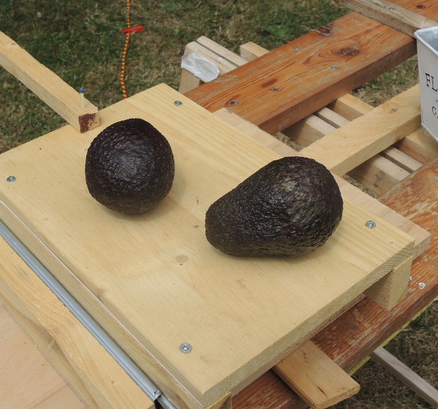
| Abb. 02-01: Zwei Avocados. Zwischen
beiden bildet sich eine Resonanz aus. Wie sieht die Struktur aus, wenn der Beobachter eine Avocado in die Hand nimmt und um die andere Frucht auf dem Brett zunächst kreisförmig herumläuft? Dabei sucht er nach Orten mit erhöht spürbarer Intensität. Wenn er etwas gefunden hat, verfolgt er dieses Strukturelement und markiert es mit Schnüren oder farbigen Wäscheklammern. Two avocados. A resonance is formed between the two.(FB) |
||||||||||||||||||||||||||||||||
 |
||||||||||||||||||||||||||||||||
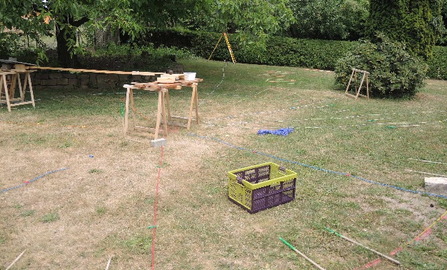
Abb. 02-02: Es gibt strahlenförmige
Elemente (mit Schüren ausgelegt) und ringförmige
(mit Wäschklammern markiert. Im Hintergrund das
Stativ für das Tachymeter zur Einmessung der
Markierungen. Links oben die Mauer mit dem Nußbaum There are beam-shaped elements (laid out with stokers) and ring-shaped ones (marked with clothespins). In the background the tripod for the total station for measuring the markings. On the top left the wall with the walnut tree (FB) |
||||||||||||||||||||||||||||||||
 |
||||||||||||||||||||||||||||||||
Abb. 02-03: blaue, rote und gelbe
Wäscheklammern an den Schnüren.blue, red and yellow clothespins on the strings. (FB) |
||||||||||||||||||||||||||||||||
 |
||||||||||||||||||||||||||||||||
| Abb. 02-04: Markierte Positionen sind
mit kleinen Kreisen dargestellt. Die
Verbindungslinien entsprechen dem Verlauf der
gefundenen Elemente. Die Kreise wurden durch
Meßpunkte gelegt und sollen schematisch die
gefundenen Ringstrukturen andeuten. Nicht alle
Meßpunkte lassen sich mit diesen Kreisen verbinden.
Der Abstand der Markierungen und damit der Abstand
zwischen den Kreise nimmt nach außen hin zu. Der Halbkreis links zeigt die Mauer an. Marked positions are shown with small circles. The connecting lines correspond to the course of the found elements. The circles were placed through measuring points and shall schematically indicate the found ring structures. Not all measuring points can be connected with these circles. The distance of the markings and thus the distance between the circles increases towards the outside. |
||||||||||||||||||||||||||||||||
 |
||||||||||||||||||||||||||||||||
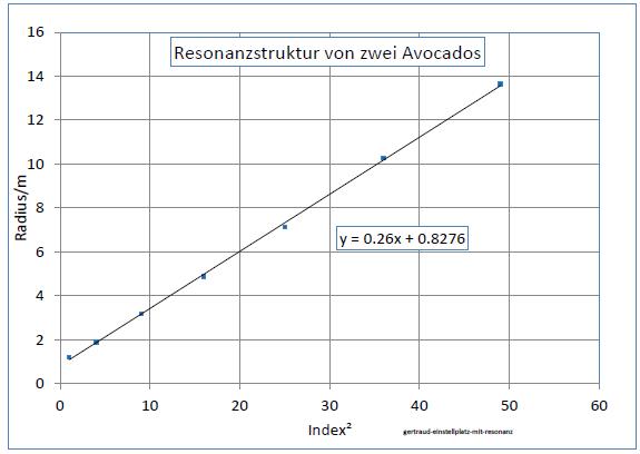
| Abb. 02-05: Radien über dem Quadrat
vom Index ergeben eine Gerade. Radii above the square of the index result in a straight line. (FB) |
||||||||||||||||||||||||||||||||
 |
||||||||||||||||||||||||||||||||
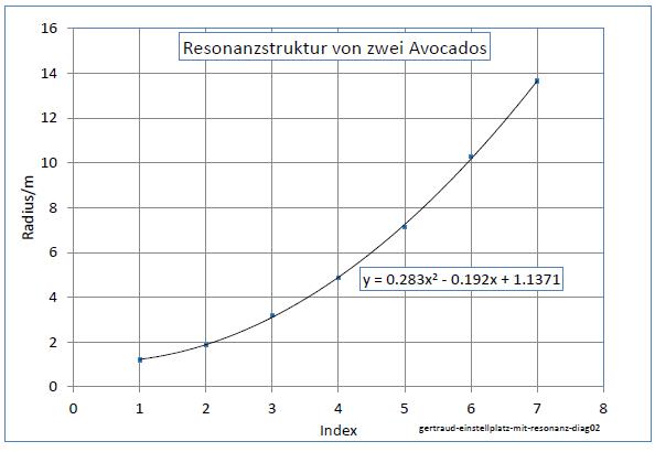
Abb. 02-06: Radien über dem Index
ergeben eine Parabel.Radii above the index result in a parabola. (FB) |
||||||||||||||||||||||||||||||||
Die in Abbildung 02.04 angegebenen Maße wurden über einer fortlaufenden Zahl (Index) aufgetragen. Die Abstände proportional zum Quadrat einer fortlaufenden Zahl. The dimensions given in Figure 02.04 were plotted over a consecutive number (index). |
 |
www.biosensor-physik.de | (c)
23.03.2010 - 28.12.2023 F.Balck |
© BioSensor-Physik 2023 · Impressum